Hello, I am having issues trying to use the Unity Line Renderer in version 2022.2.5f1 as well as placing objects on the map appropriately.
I have looked at the "Measuring Distance" sample as well as the "Routing" sample that look to utilize the Line Renderer system, but I can't seem to figure out exactly how theirs works.
Currently, I read a GeoJSON file and grab all the coordinates for each feature. I then create a gameObject to house the Line Renderer component, and then I go into the coordinates for the feature and create a gameObject for each coordinate point, adding an ArcGISLocationComponent to each. I then have a list of all these coordinate gameObjects, and then set the main LineRenderer positions to those gameObject positions, which is where I hit the snag.
I do not know if the LineRender component understands the difference between the High-Precision Transform and a regular Transform. I can confirm that the coordinate gameObjects are placed appropriately on the map, but I can't use their regular transform since it's all zeroed out, and the HPTransform gives me huge numbers that I don't think the LineRender understands as being HPTransform, as seen in the screenshot below.
Ideally, I would like to not have to create a gameObject for each individual coordinate/point, but I do not know how I can convert lat/long coordinates into ArcGIS map coordinates to Unity world coordinates let alone do this all via code.
EDIT: Additionally, sometimes seemingly at random the points that are set in the Line Renderer are all the same value, even though nothing has changed code wise. It's incredibly frustrating, as I don't know what's causing this or what values I should be inputting into the LineRenderer to properly do what I need it to do.
Is there a way I could create a scene layer from the GeoJSON file? From what I've seen it looks like I'd need to use ArcGISPro, but I'm unsure how I can export a scene layer from that to then use in Unity.
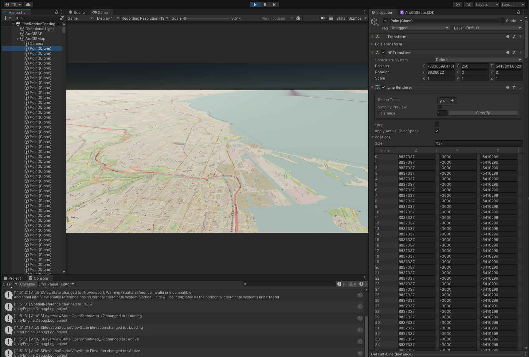
Below is the base code that I've made. I've commented it out to explain my methodology. Is there anything in particular I am not doing?
using System.Collections;
using System.Collections.Generic;
using Esri.ArcGISMapsSDK.Components;
using Esri.ArcGISMapsSDK.Utils.GeoCoord;
using Esri.GameEngine.Geometry;
using Esri.HPFramework;
using GeoJSON;
using Newtonsoft.Json.Linq;
using UnityEngine;
using Unity.Mathematics;
using System.Drawing;

public class GeoJSONRenderer : MonoBehaviour
{
    // Start is called before the first frame update
    public TextAsset jsonFile;
    public GameObject arcGISMap;
    public GameObject obj;
    public Material mat;

    private double3 lastRootPosition;

    ArcGISMapComponent arcGISMapComponent;

    List<LineRenderer> lineRenderers = new List<LineRenderer>();

    void Start()
    {
        arcGISMapComponent = FindObjectOfType<ArcGISMapComponent>();
        //lastRootPosition = arcGISMapComponent.GetComponent<HPRoot>().RootUniversePosition;

        // Delaying the LineRenderer creation so ArcGIS has time to generate the map
        StartCoroutine(TimingRenders());
    }

    private void RebaseLine(LineRenderer lr)
    {
        double3 rootPosition = arcGISMapComponent.GetComponent<HPRoot>().RootUniversePosition;
        Vector3 delta = (lastRootPosition - rootPosition).ToVector3();
        if (delta.magnitude > 1) // 1km
        {
            if (lr != null)
            {
                Vector3[] points = new Vector3[lr.positionCount];
                lr.GetPositions(points);
                for (int i = 0; i < points.Length; i++)
                {
                    points[i] += delta;
                }
                lr.SetPositions(points);
            }
            lastRootPosition = rootPosition;
        }
    }

    private IEnumerator TimingRenders()
    {
        float Timer = 3.0f;
        yield return new WaitForSeconds(Timer);
        LineRendering();
    }

    // We run this function a few seconds after startup because for some reason ArcGIS needs a few seconds to get its **bleep** together
    private void LineRendering()
    {
        FeatureCollection col = GeoJSONObject.Deserialize(jsonFile.text);

        foreach (FeatureObject f in col.features)
        {
            // Get a list of all the position objects from the FeatureCollection JSON
            List<PositionObject> p = f.geometry.AllPositions();

            // Create a gameObject to house the LineRenderer for this particular collection
            GameObject lineObj = Instantiate(obj, transform.position, Quaternion.identity, arcGISMap.transform);
            LineRenderer lr = lineObj.AddComponent<LineRenderer>();
            ArcGISLocationComponent lineRenderLocComp = lineObj.AddComponent<ArcGISLocationComponent>();
            lineRenderLocComp.Position = new ArcGISPoint(p[0].longitude, p[0].latitude, 250.0f, ArcGISSpatialReference.WGS84());

            // Go through each position
            // Place them appropriately on the map using their coordinates
            List<GameObject> positions = new List<GameObject>();
            // ArcGISGeometry multiP = ArcGISGeometry.FromJSON(jsonFile.text, ArcGISSpatialReference.WGS84());

            foreach (PositionObject o in p)
            {
                // There's a 3000 Y offset set in for some reason, need to counter that
                ArcGISPoint point = new ArcGISPoint(o.longitude, o.latitude, 250.0f, ArcGISSpatialReference.WGS84());
                GameObject mainObj = Instantiate(obj, Vector3.zero, Quaternion.identity, arcGISMap.transform);

                ArcGISLocationComponent locComp = mainObj.AddComponent<ArcGISLocationComponent>();
                locComp.Position = point;
                positions.Add(mainObj);

                //locComp.SyncPositionWithHPTransform();
                //HPTransform hpTrans = mainObj.GetComponent<HPTransform>();

                // Vector3 worldPoint = arcGISMapComponent.View.GeographicToWorld(point).ToVector3();
                    //Add(new Vector3(
                    //(float)hpTrans.LocalPosition.x,
                    //(float)hpTrans.LocalPosition.z,
                    //(float)hpTrans.LocalPosition.y
                    //)
                //); // (worldPoint);
            }

            lr.positionCount = positions.Count;

            List<Vector3> points = new List<Vector3>();
            foreach(GameObject obj in positions)
            {
                points.Add(obj.transform.position);
            }

            lr.SetPositions(points.ToArray());

            lr.startWidth = 100.0f;
            lr.endWidth = 100.0f;

            lr.material = mat;
            lr.material.color = UnityEngine.Color.red;

            lineRenderers.Add(lr);
        }
    }

    // Update is called once per frame
    void Update()
    {
        foreach(LineRenderer lr in lineRenderers)
        {
            RebaseLine(lr);
        }
    }
}

