Hi All,
Our organization loves Field Maps, but it has an extremely painful issue that does not happen to the Collector.
For example, if we have a filed maps designed to display same asset (Water Valve) with different symbology based on different definition queries.
Layer 1:
Name: WaterValve
Definition Query: Status = 'Existing' And UsuallyOpen = 'Yes'
Layer 2:
Name: WaterValve - Usually Closed
Definition Query: Status = 'Existing' And UsuallyOpen = 'No'
Layer 3:
Name: WaterValveInspection (In 3 Years)
Definition Query: DATEDIFF(d, ClosedDate , GETDATE()) <= 1095
Then, we published it to our Portal and Server (federated), and create a web map for Field Maps.
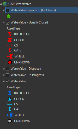
When our field staff try to click on the valve and click the chain-link icon, and click "WaterValveInspection (In 3 Years)" to add a new inspection record. The Field Maps will crash...just close the app by itself without any error message or warning. However, the same map will not crash by using "Collector"...
Then, just for testing purpose, I publish another feature layer service without the layer "WaterValve - Usually Closed", and Field Maps will allow our field workers to add the new inspection record with linked "AssetID" (auto-filled) without issues.
This issue is extremely painful since
- ArcGIS Pro or any other ArcGIS products doesn't have much flexibility in having symbology based on multiple values of different fields. Please see the following MapGuide web layer symbology example...

I couldn't belive an enterprise GIS can't do something like this, but an Open Sourve web GIS can do this type of symbology so easily.
- Due to the first point, I have to create layers with different definition queries in order to display my assets with different symbologies
- However, if I do that... relationship based inspection/maintenance records cannot be added using Field Maps, since it will CRASH...lol
- Then, our staff have to publish seperated Feature Layer service on Portal in order to allow our Field workers to see the display of layers with different symbologies and be able to do the inspeciton at the same time...
ESRI... please hear my cry, and do something about this. Believe me...this improvement will make Filed Maps embraced by more users and organizations.
Thanks,
Reno

