Hi, more questions about vector-tiles on my end 🙂
I'n not sure if this is in the correct section since it's touching different things. But since the vectortilepackage/service is created in ArcGIS Pro I'll post this here.
I try to create a vector tile service with border-sharing-polygons with simple dashed-outlines. The polygons are grouped by unique values / an attribute (and additionally have alternate symbols). The outlines have a solid stroke layer (white) and above a dashed stroke layer (black). To give a example: Think of displaying Country-borders, symbolized by unique values, grouped by "continent".
ArcGIS Pro handles that well and does not "stack" the dashed outlines within the same unique value group which could result in a solid line... however, viewing the result after publishing as vector tile package / vector tile service is different:
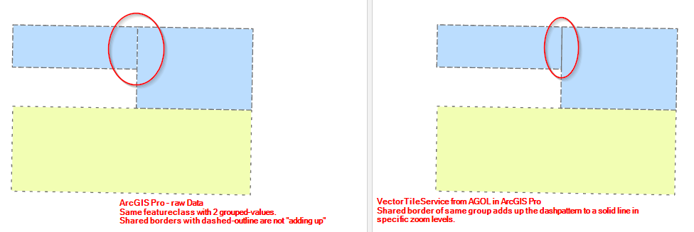
As far as I understand it: All "top-stroke-layers" from the same unique-value-group are drawn together. So within a group they will overlap and stack the dash-pattern into a solid line. The second stroke layer (solid white) does not help, since it is drawn as "layer-2", after the already stacked dashed lines "layer-1". Borders to polygons from other groups work fine... that group will be "overdrawn".
> Is there any way to fight against or work around that effect for vectortiles?
The only «solution» I found so far is, not to group the unique values or better said, taking a unique value that is unique for every single feature...every draw-layer of every feature would be drawn seperatly. But that's not actually a solution for me since there are >200k features and they are updated daily with changed and new features.
Any kind of hints and tips are very welcome 🙂

