Hey Everyone --
Working from 4.18.
I have a new project requirement to map out polylines that represent circuits. The circuit graphics are created on the client side. They will all begin at one point and will shoot outwards from there.
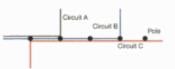
My major issue is that I can have multiple circuits running the same track and multiple circuits that are smaller parts of one larger track. The beginning and end latitude and longitude are the same. Or, the beginning coordinates are the same, and the circuit follows the same track, but it does not run the entire distance.
After researching how to visually represent circuits, I found ESRI provides this idea to offset circuits that are overlapping. I would like to implement this idea for a POC.
I've found offset in the geometry engine (https://developers.arcgis.com/javascript/latest/api-reference/esri-geometry-geometryEngineAsync.html#offset) but I'm wondering if anyone has an example of this running properly?
Thanks so much!
Goal visual: