I am using ArcGIS Pro 2.7.1 and I am trying to create a new grid in a layout showing Township and Range. When I format the grid and go to the "Components" tap to choose the edges under the "Visible" section, I am unable to choose an edge. Everything there is greyed out and I get this pop-up text when hovering over the numbers:
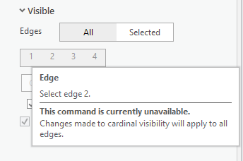
The source polygon layer is located in the same Feature Dataset that the other layers are in and all of the coordinate systems match. Not sure what the issue is here.
Thanks
Will


