Hello,
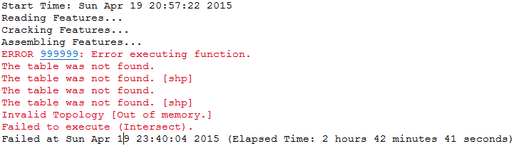
I have been receiving error message during intersecting process (picture). I am trying to intersect between these two layers: 1) city boundaries and 2) buffers of those cities. Have anyone face this issue before? Please let me know how to solve it.
Thanks in advance!
Tom.
What are the input and output names? I ask because this looks like file naming may be the culprit - never name anything starting with anything but a letter and only use alphanumeric characters plus "_".
input names:
1) scag_2010_blockgroups
2) scag_2010_blockgroups_3mi_bffr_LA
Output name:
1) scag_2010_blockgroups_3mi_bffr_LA_intrsct
There are sveral limitations when using shapefiles as an output, such as field name length. Perhaps one of these is tripping you up?
They are listed here: ArcGIS Desktop
This is only a problem for feature classes, by the way. You can name shapefiles starting with a number.
Oh, just a thought--if the output location of these files is not a GDB, are you adding the .shp to the end of the file name?
Sephe,
Thanks for the info. This spatial analysis worked with 1 mile buffer but, for some reasons, it does not work for 3 mile buffer. I've tried to save the output in GDB as well but the problem still exists.
Interestingly, I performed a same procedure (intersect) for a different area with less records and it worked. I am thinking it is because I have too many records after intersecting the two layers? This may be the case..
How many records are there? You can quickly tell by selecting by location the parcels that intersect your buffers.
You might try running the Repair Geometry tool on your layers first, since you're getting a topology error. Also, do any of your layers have M or Z values?
Two things stick out to me - 'Invalid topology' and 'out of memory'
Maybe look at these threads
Invalid Topology [OUT_OF_MEMORY]
Dissolve Error 999999 Invalid Topology Out of memory You might want to try using the Repair Geometry tool on your dataset?ArcGIS Help 10.1 Could it have anything to do with multipart features in your parcel data?
ArcGIS 10 Pre-release Intersect Failure on Large Dataset - Make sure your computer is up to minimum requirements
Have you looked in the geoprocessing results window? Perhaps if you look at the messages there is more detailed error information? What about checking the environment variables and inputs there too. Tried turning off Background Geoprocessing?
Sephe and Sol, thank you both for your suggestions.
I am running ArcGIS on a server that has 32gb of RAM. I will repair my geometry and shorten my file path name. It's just weird to me that the same process worked for 1 mile buffer.
Yes, ArcGIS can be quirky in what works and what doesn't sometimes, but one explanation could be that there are geometry problems only in areas outside of those 1 mile buffers. I hope it works, and I'm sorry we hijacked your thread a little with the workings of GeoNet. Let us know!
Thanks. Will try and post my results here.
By the way, should i put all my working feature datasets into gdb?
Hi Tom,
I would try the Repair Geometry tool first as everyone else suggested. However, if even that does not do the trick for you do check for ‘Dicing Godzillas’. It occurs with features with too many vertices. Though there is no limit specified for executing a Geoprocessing tool however this error: 999999 which is a generic error is often seen when the vertices exceed 2 million in the features.
Here’s a link for your reference as how you can calculate the number of vertices for your input features.
Dicing Godzillas (features with too many vertices) | ArcGIS Blog
I hope this helps!
I tried the 'Repair Geometry' tool but the error still exists. However, i reduced the size of the dataset, it did not give me any error messages.
At this point, I feel it is giving me error message is because my data is exceed that '2 million vertices'. I will go ahead and check out 'Dicing Godzillas' for any solutions..
Thanks,
Tom
Rakesh,
I checked my number of vertices; both of my layer have the the MAX of VERTICES less than 2 million. I don't think this is the case.
The short term solution is to reduce the size of the dataset. As in the picture below, there are many overlapping areas created by the buffers.
Maybe the output's data size is too large that the software could not handle...that could also be one of the reasons.
Holy moly! That is a lot of buffers! Did you get a chance to read some of the links that Sol posted? I would also advise googling the problem, as I saw a lot of possible reasons and solutions out there when I did so.
Yeah, that's a lot of buffers...
I'm not one to suggest support right away, but I think you've done your due diligence in trying to figure this one out on own and the help of others. Is tech support an option for you? If you do open a support incident, provide them the link to this thread so they can see what you have already tried. I would ask to be escalated to a more advance support analyst from the beginning too, maybe one of the ESRI people here can take your case, IDK?
Yup, there are lots of buffers! That is just a portion of it..haha.
I already checked those links that Sol posted. It is all about Repair Geometry and computer requirements. I believe the server I am using is satisfied with the software requirement. I performed Repair Geometry once but the error still exists.
Sol, yeah that is a lot of buffers....roughly 11k buffers for the study area.
I have tried different ways but still couldn't fix the issue. My next step is to contact the ESRI support team to see if they have any solutions...
Do you know a link where i can open the ticket?
Can we retreat to the reason 'why' you are trying to do this? What is the purpose. Are you trying to generalize a boundary? To consider:
As you can tell by the results...it just isn't going to happen in its current state, and you may not need it in the first place.
Dan,
I am trying to calculate the job accessibility based on distance from the centroid of census tracts. By doing intersect, I can be able to calculate the proportion of the census tracts.
Hmmm, perhaps a better way to do this is to use the Near tool from the proximity toolset. You can set a search radius equivalent to your buffer.
Ahhh... but it still isn't working for me, since you are using straight-line distance, hence a buffer (circle), and from that trying to estimate the proportion (of population?) of the census tract. I presume that this is some standard measure that has been used by others...if so fine. If not, I would suggest using network distance to delineate a 'service area' from the centroid to obtain the geometry for intersection...which is going to make your situation perhaps slightly better if the ngon has fewer sides than a circle.
I think a picture, not obliterated by circles, and some proposed calculations may be in order to simplify your dilemma and demonstrate the measure you are actually after.
I agree with Dan, I need either a visual and/or more details to understand exactly what you're trying to accomplish.
Strange how this thread is evolving, there is still the dilemma of what is causing the error with the geoprocessing tool (I can't help but wonder what the root cause of that was) but if there is a least cost path to the solution you are looking for then that kind of becomes a moot point. In hindsight, it might have been a good idea to ask more about the details of the solution you are trying to achieve in the very beginning. However, it's hard to determine in advance which will be more helpful, asking the user what their goal is and working from their or answering the specific problem they are stuck on in the middle of their project.
It is quite possible that the output which is to be generated goes beyond the 2 million vertices mark and hence hitting the Dicing Godzillas. Does both your input feature together goes beyond the 2 million mark? I may be wrong but I have a very strong feeling it is the case here and specially after smaller datasets just works fine. I guess one of the Esri tech support analysts would be in a better position to test the issue with the data and give you an appropriate resolution/reason just in case you would like to go that route.
As already mentioned by Sol please do mention this thread in the support request form such that the analyst gets a fair idea what has been tried as of now and what needs to be done. Thanks Tom!
Signed in members can post, follow updates, and more. New here? Register a free account.
Find useful guides, FAQs, and documents to help you navigate and make the most of Esri Community.