<\/HEAD>
Die ArcGIS Platform<\/A> vereint Karten, Apps, Daten und Menschen, um intelligentere Entscheidungen zu treffen und Innovationen in Ihrer Organisation und Gemeinschaft zu ermöglichen. ArcGIS beinhaltet einen Living Atlas of the World<\/A> mit schönen und autoritativen Karten zu Hunderten von Themen<\/A>. Der Living Atlas kombiniert Referenz- und Themenkarten mit vielen Themen, die sich auf Menschen<\/A>, Erde<\/A> und Leben<\/A> beziehen. Dieser Inhalt ist von jedem Gerät aus, überall und jederzeit verfügbar.<\/P> <\/A><\/P>
<\/P>
2014 war ein arbeitsreiches Jahr für das ArcGIS Content Team. Die Inhaltslandschaft von Esri hat sich enorm erweitert. Diese Zunahme ist hauptsächlich darauf zurückzuführen, dass Inhalte erstellt und in die vielfältigen Sammlungen des
Living Atlas of the World<\/A> kuratiert wurden und Daten umfasst, die durch die Teilnahme an Community Maps<\/A> zu Esris Online Basemaps<\/A> beigetragen wurden. Diese Geschichte konzentriert sich auf die wachsenden Inhalte, die den Living Atlas unterstützen, einschließlich einer Einführung unserer Kuratoren, und beschreibt das Wachstum der Basemaps im Jahr 2014.<\/P>Inhalte, die den
Living Atlas of the World<\/A> unterstützen, sind nach Themen organisiert. Inhalte im Atlas werden von Esri, der Benutzer-Community und Esris Partnern veröffentlicht.<\/P> <\/A><\/P>
Jedes dieser Themen hat einen Kurator, der sicherstellt, dass alle Webkarten, Apps und Daten bewährte Verfahren befolgen, Mehrwert bieten und eine Grundlage für Ihre Arbeit schaffen. Werfen wir einen Blick auf diese vielfältigen Themen und lernen unsere Kuratoren kennen.<\/P>
Basemaps<\/STRONG><\/P>
 <\ / A ><\ / P >< P style = " margin :0 0 10 px ;font - family :Arial ,Helvetica ,sans - serif ;color :#333333 ;font - size :14 px ; " >< A href = " http : \/ \/ doc . arcgis . com \/ en \/ living - atlas \/# s =0 & n =0 & d =1 & col = la - basemaps
  & fs =0 & fn =30 & npp =0 & subCat =0 & md = la - basemaps :111 " style = " color :#007ac2 ; " target = " _ blank " rel = " nofollow noopener noreferrer " >< IMG alt = " " class = " alignnone jive - image wp - image -43282 " height = "413 " src = " http : \/ \/ blogs . esri . com \/ esri \/ arcgis \/ files \/2014 \/10 \/ Basemaps . jpg " style = " background - color :#f5f5f5 ; border : none ; margin :0 px 20 px 10 px 0 px ; padding :10 px ; width :865 px ; height :412.7064702788006 px ; " width = "865 " \/ ><\ / A ><\ / P >< P style = " margin :0 0 10 px ;font - family :Arial ,Helvetica ,sans - serif ;color :#333333 ;font - size :14 px ; " >< STRONG > Imagery <\ / STRONG ><\ / P >< P style = " margin :0 0 10 px ;font - family :Arial ,Helvetica ,sans - serif ;color :#333333 ;font - size :14 px ; " >< A href = " http : \/ \/ media . esri . com \/ videos \/ events \/ uc \/2014 \/ Imagery _720p . mp4 " style = " color :#007ac2 ; " target = " _ blank " rel = " nofollow noopener noreferrer " >< IMG alt = " " class = " alignnone wp - image -43287 jive - image size - full " height = "313 " src = " http : \/ \/ blogs . esri . com \/ esri \/ arcgis \/ files \/2014 \/10 \/ Imagery . jpg " style = " background - color :#f5f5f5 ; border : none ; margin :0 20 px 10 px 0 ; padding :10 px ; " width = "267 " \/ ><\ / A ><\ / P >< P style = " margin :0 0 10 px ;font - family :Arial ,Helvetica ,sans - serif ;color :#333333 ;font - size :14 px ; " >< A href = " http : \/ \/ doc . arcgis . com \/ en \/ living - atlas \/# s =0 & n =0 & d =1 & col = la - imagery :5 & fs =0 & fn =30 & npp =0 & subCat =0 & md = la - imagery :11111 " style = " color :#007ac2 ; " target = " _ blank " rel = " nofollow noopener noreferrer " >< IMG alt = " " class = " alignnone wp - image -43288 jive - image " height = "416 " src = " http : \/ \/ blogs . esri . com \/ esri \/ arcgis \/ files \/2014 \/10 \/ Imagery1 . jpg " style = " background - color :#f5f5f5 ; border : none ; margin :0 px 20 px 10 px 0 px ; padding :10 px ; width :868 px ; height :415.74553101997896 px ; " width = "868 \ / > <\ / A > <\ / P > < P style= \ margin :0 0 10 px;font-family :Arial ,Helvetica ,sans-serif;color:#333333;font-size :14 px \ > < STRONG > Demographics and Lifestyles <\ / STRONG > <\ / P > < P style= \ margin :0 0 10 px;font-family :Arial ,Helvetica ,sans-serif;color:#333333;font-size :14 px \ > < A href= \ http://media.esri.com/videos/events/uc/2014/Statistical-short_720p.mp4 \ style= \ color:#007ac2 \ target= \ _blank \ rel= \ nofollow noopener noreferrer \ > < IMG alt= \ \ class= \ alignnone wp-image-43290 jive-image size-full \ height= \308 src= \ http://blogs.esri.com/esri/arcgis/files/2014/10/Curator_DemographicsLifestyles.jpg \style= \ background-color:#f5f5f5;border:none;margin:0 20px 10px 0;padding:10px;width=265 \ /> <\ / A > <\ / P > < P style= \ margin :0 0 10 px;font-family :Arial ,Helvetica ,sans-serif;color:#333333;font-size :14 px \ > < A href= \ http://doc.arcgis.com/en/living-atlas/#s=0&n=0&d=1&col=la-demographics:7&fs=0&fn=30&npp=0&subCat=0&md=la-demographics:1111111 \style= \ color:#007ac2 \ target= \ _blank \ rel= \ nofollow noopener noreferrer \ > < IMG alt= \ \ class= \ alignnone wp-image-43291 jive-image \ height=419 src=\ http://blogs.esri.com/esri/arcgis/files/2014/10/Demographics.jpg\style=\ background-color:#f5f5f5;border:none;margin:-20px-101010;padding:-20;width:-868;height:-419.3656480505796\ /> <\ / A > <\ / P > < P style= \ margin :-00-101410;font-family :-Arial,-Helvetica,-sans-serif;color:-#333;font-size :-14pt;-webkit-text-stroke-width:-thin;-webkit-text-stroke-color:-transparent;-webkit-text-fill-color:-transparent;-webkit-font-smoothing:-antialiased;-moz-osx-font-smoothing:-grayscale;-moz-font-feature-settings:-liga off;-moz-font-feature-settings:-liga off;-moz-font-feature-settings:-liga off;-moz-font-feature-settings:-liga off;-moz-font-feature-settings:-liga off;-moz-font-feature-settings:-liga off;-moz-font-feature-settings:-liga off;-moz-font-feature-settings:-liga off;-moz-font-feature-settings:-liga off;-moz-font-feature-settings:-liga off;-moz-font-feature-settings:-liga off;-moz-font-feature-settings:-liga off;-moz-font-feature-settings:-liga off;-moz-font-feature-settings:-liga off;-moz-font-feature-settings:-liga off;-moz-font-feature-settings:-liga off;-moz-font-feature-settings:-liga off;-moz-font-feature-settings:-liga off;-moz-font-feature-settings:-liga off;-moz-font-feature-settings:-liga off;-moz-font-feature-settings:-liga off;-moz-font-feature-settings:-liga off;-moz-font-feature-settings:-liga off;-moz-font-feature-settings:-liga off;-moz-font-feature-settings:-liga off;-moz-font-feature-settings:-liga off;-moz-font-feature-settings:-liga off;-webkit-text-stroke-width-thin ;-webkit-text-stroke-color-transparent ;-webkit-text-fill-color-transparent ;-webkit-font-smoothing-antialiased ;-moz-osx-font-smoothing-grayscale ;-moz-font-feature-settings-liga-off ;-moz-font-feature-settings-liga-off ;-moz-font-feature-settings-liga-off ;-moz-font-feature-settings-liga-off ;-moz-font-feature-settings-liga-off ;-moz-font-feature-settings-liga-off ;-moz-font-feature-settings-liga-off ;-moz-font-feature-settings-liga-off ;-moz-font-feature-settings-liga-off ;-moz-font-feature-settings-liga-off ;-moz-font-feature-settings-liga-off ;-moz-font-feature-settings-liga-off ;-moz-font-feature-settings-liga-off ;-moz-font-feature-settings-liga-off ;-webkit-text-stroke-width-thin ;-webkit-text-stroke-color-transparent ;-webkit-text-fill-color-transparent ;-webkit-font-smoothing-antialiased ;-moz-osx-font-smoothing-grayscale ;-webkit-text-stroke-width-thin ;-webkit-text-stroke-color-transparent ;-webkit-text-fill-color-transparent ;-webkit-font-smoothing-antialiased ;-webkit-text-stroke-width-thin ;-webkit-text-stroke-color-transparent ;-webkit-text-fill-color-transparent">Lifestyles<\ / STRONG ><\ / P > href="http:\/\/doc.arcgis.com\/en\/living-atlas\/#s=0&n=0&d=1&col=la-landscape:14&fs=0&fn=30&npp=0&subCat=0&md=la-landscape:11111111111111" style="color: #007ac2;" target="_blank" rel="nofollow noopener noreferrer">
 <\/A><\/P>Landschaft – Ozeane<\/STRONG><\/P>
 <\/A><\/P>
 <\/A><\/P>
Beobachtungen der Erde<\/STRONG><\/P>
 <\/A><\/P>
 <\/A><\/P>
Städtische Systeme<\/STRONG><\/P>
 <\/A><\/P>
 < \/ A >< \/ P >< P style = "margin :00 px1014 px ; font-family :Arial , Helvetica , sans-serif ; color :#333333 ; font-size :14 px ; " >< STRONG > Städtische Systeme – 3D-Städte < \/ STRONG >< \/ P >< P style = "margin :00 px1014 px ; font-family :Arial , Helvetica , sans-serif ; color :#333333 ; font-size :14 px ; " >< A href = "http://media.esri.com/videos/events/uc/2014/3D cities_720p.mp4 " style = "color:#007ac2 ; " target = "_blank " rel = "nofollow noopener noreferrer " >< IMG alt = " " class = "wp-image-43309 alignnone jive-image size-full " height = "315 " src = "http://blogs.esri.com/esri/arcgis/files/2014/10/Curator_UrbanSystems3D.jpg " style = "background-color:#f5f5f5 ; border:none ; margin :020 px10140 px ; padding :10 px ; " width = "247 " \/ >< \/ A >< \/ P >< P style = "margin :00 px1014 px ; font-family :Arial , Helvetica , sans-serif ; color :#333333 ; font-size :14 px ; " >< A href = "http://doc.arcgis.com/en/living-atlas/#s=0&n=0&d=1&col=la-urban-observatory:7&fs=0&fn=30&npp=0&subCat=1&md=la-urban-observatory:0000001 " style = "color:#007ac2 ; " target = "_blank " rel = "nofollow noopener noreferrer " >< IMG alt = " " class = "alignnone wp-image-43310 jive-image " height = "417 " src = "http://blogs.esri.com/esri/arcgis/files/2014/10/UrbanSystems_3D.jpg " style = "background-color:#f5f5f5 ; border:none ; margin :020 px10140 px ; padding :10 px ; width :868 px ; height :416.5481481481482 px ; " width = "868 " \/ >< \/ A >< \/ P >< P style = "margin :00 px1014 px ; font-family :Arial , Helvetica , sans-serif ; color :#333333 ; font-size :14 px ; " 0 0 10px; Schriftfamilie: Arial, Helvetica, sans-serif; Farbe: #333333; Schriftgröße: 14px;">Community Maps spielte in diesem Jahr eine entscheidende Rolle, indem neue und aktualisierte Inhalte zur World Topographic Map hinzugefügt wurden. Neue Beiträge in den Vereinigten Staaten umfassten King County, WA; Crook County, OR; Los Angeles und Anaheim, CA; Sparks, NV; Mesa und Queen Creek, AZ; City of Aspen und Pitkin County, CO; Teton County, ID und WY; Oswego, IL; Plano und Montgomery, TX; Shelby County, TN; Tampa, FL; Goldsboro, NC; Milford, CT; und viele andere. Neue Beiträge aus der internationalen Gemeinschaft umfassen Dänemark; Insel Bermuda; Berlin, Deutschland; Wien, Österreich; Alberta, British Columbia und Sudbury, Ontario, Kanada und viele andere.
Diese Gemeinden sind nicht nur dem Community Maps Program beigetreten, das ArcGIS Content Team hat auch Inhalte von diesen Beitragsleistenden genutzt und ausgewählte Kartenebenen zur World Streets Map, der Light Gray Canvas Map hinzugefügt. Es gibt Pläne, diese Ebenen bald auch zu anderen Basiskarten hinzuzufügen. Wir haben nicht nur neue und aktualisierte Inhalte eingeführt, sondern stellen die Inhalte der Beitragsleistenden jetzt bis zu einem Maßstab von 1:288K dar. Zuvor waren diese Inhalte nur bis zu einem Maßstab von 1:9K sichtbar. Zusätzlich wurden kommerzielle Daten für ganz Nordamerika aktualisiert und alle Inhalte in Nordamerika im neuen kartografischen Design zwischengespeichert.
Bereit nutzbare Basiskarten und Inhalte sind Teil Ihres ArcGIS Online Subscription. Dies umfasst Karten, intelligente Kartenebenen, Bildwerkzeuge, Live-Feed-Ebenen, Höhenservices und Web-Apps. Was bekomme ich sonst noch?
Das untenstehende Bild zeigt die Community-Beitragsleistenden in der World Topographic Map.
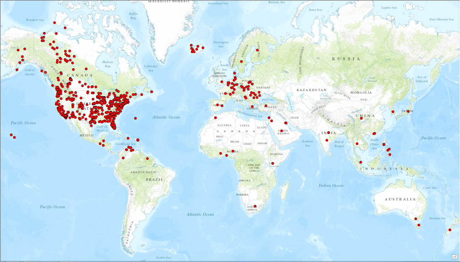
134 Millionen Features wurden durch Community-Beiträge eingereicht!
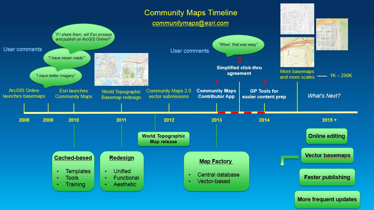
Die Community Maps Timeline hebt die programmatischen und operativen Verbesserungen hervor, die unser Team im Jahr 2014 umgesetzt hat.
Wir möchten unserer Benutzer-Community und unseren Partnern für ihre Unterstützung beim Aufbau unserer Basiskartensammlung und bei der Unterstützung des Living Atlas of the World danken.
