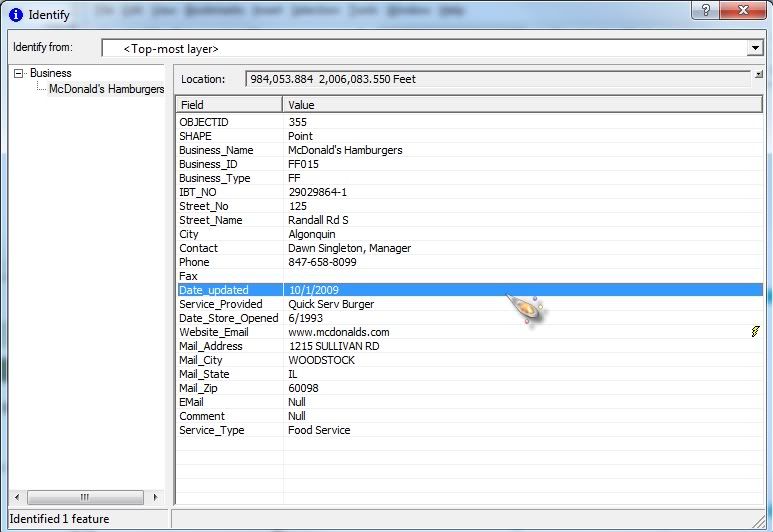
Caitlin, Can you take a screen shot of what you are entering into the widget and post it as well?
<layer> <name>Local Businesses</name> <url>http://server/ArcGis/rest/services/GIS/Community/MapServer/0</url> <expression useforspatial="true">upper(business_name) LIKE upper('%[value]%')</expression> <textsearchlabel>Search by Address [ Example: Buger King]:</textsearchlabel> <graphicalsearchlabel>Use one of the graphical search tools to select incidents</graphicalsearchlabel> <spatialsearchlabel>Select the two layers for spatial query</spatialsearchlabel> <spatialsearchlayer>true</spatialsearchlayer> <spatialrelationlayer>true</spatialrelationlayer> <titlefield>Address</titlefield> <fields all="false"> <field name = "Business_Name" alias="Business Name" /> <field name = "Business_Type" alias="Type" /> <field name = "Website_Email" alias="Website" /> </fields> <linkfield linkfieldprefix = "">Website_Email</linkfield> <icon isfield="true"></icon> <zoomscale>1000</zoomscale> </layer>
http://server/t-assessor.asp?pid=http://server/t-assessor.asp?pid=352585475474
<layer> <name>Parcel ID</name> <url>http://server/ArcGIS/rest/services/Parcels/MapServer/2</url> <expression useforspatial="true">PARCELID like '%[value]%'</expression> <textsearchlabel>Search by Parcel ID [ Example: 350736600508 ]:</textsearchlabel> <graphicalsearchlabel>Use one of the graphical search tools to select a Parcel</graphicalsearchlabel> <spatialsearchlabel>Select the two layers for spatial query</spatialsearchlabel> <spatialsearchlayer>true</spatialsearchlayer> <spatialrelationlayer>true</spatialrelationlayer> <titlefield></titlefield> <fields all="false"> <field name="PARCELID" alias="PARCEL ID" gridfield="true" gridfieldonly="true"/> <field name="PHOTOS" alias="PARCEL INFORMATION" gridfield="false" gridfieldonly="false" hyperlinkgridfield="true" hyperlinkaliastext="Assessor Information" linkprefix="http://server/t-assessor.asp?pid=" linksuffix=""/> <field name="SITUS" alias="SITUS" gridfield="true" gridfieldonly="true"/> <field name="DEEDED_ACR" alias="DEEDED ACRES" gridfield="true" gridfieldonly="true"/> <field name="TAXPAYER_N" alias="TAXPAYER NAME" gridfield="true"/> <field name="MAIL_ADD_1" alias="C/O" gridfield="true" gridfieldonly="true"/> <field name="MAIL_ADD_2" alias="MAILING ADDRESS" gridfield="true" gridfieldonly="true"/> <field name="MAIL_ADD_3" alias="CITY/STATE" gridfield="true" gridfieldonly="true"/> <field name="ZIP_CODE" alias="ZIPCODE" gridfield="true" gridfieldonly="true"/> <field name="LINK_JPG" alias="PHOTO OF PROPERTY" gridfield="false"/> </fields> <linkfield>LINK_JPG</linkfield> <icon isfield="true"></icon> <zoomscale>10000</zoomscale> </layer>
_data = ObjectUtil.copy(value);
Dustin, I am still struggling to reproduce your issue with the viewers url getting added to you link. Unless I can reproduce it, it will be hard for me to diagnose and resolve...
Angemeldete Mitglieder können Beiträge verfassen, Updates folgen und mehr. Neu hier? Registriere ein kostenloses Konto.
Find useful guides, FAQs, and documents to help you navigate and make the most of Esri Community.