My name is Ludwig Spove, and I am an urban planning master student at Roskilde University in Denmark, and in this blog post I will talk about my experiences learning GIS in relation to urban planning and personal development.
The unexpected beginning
During the introduction week of my bachelor's in urban planning, one presentation briefly introduced Geographic Information Systems (GIS). At the time, I had no idea that a few slides would end up shaping much of my university experience. The first year had us reading urban history and theory as well as drawing maps by hand. Rather than waiting until GIS became part of the curriculum, I decided to explore it during the summer out of curiosity. This course however, proved to be more challenging than anticipated and led to many off-class hours and late nights googling and reading Esri tutorials and support pages to fully understand how I needed to use the software and what analyses could be useful.
Choosing to learn more and becoming “the GIS person”
Fast forward to the 5th semester and now classmates started asking for my help with their GIS assignments. Many evenings turned into long message threads filled with screenshots, troubleshooting, and trying to figure out why a geoprocessing tool wasn't behaving as expected. I’d like to think that helping others like that taught me almost as much as completing my own assignments. And when helping others I also had to frame it in a way that 1) helped them solve their problem, but 2) also helped them understand why the GIS software worked the way it did and why we chose to use it in the way we did. I am very grateful that I took the time to help as I think much of my GIS knowledge solidified through the collective troubleshooting and brainstorming of ideas. By then, I had become comfortable with the software. The next question became: what kinds of planning questions could I actually answer with it?
The project that made everything click
At the time, Swedish media brought up problems surrounding parents who drive their children to school in urban areas, which creates chaotic environments around the schools, but also leads to poor health conditions for these kids as they move around less in their everyday lives. As such, my own project set out to answer the following question:
How does the city of Malmö in Sweden provide children with the opportunity to cycle safely to school?
More specifically I wanted to map out which households could access a separated cycle path near their home and to explore if there were a difference in accessibility to safe cycle paths between Malmö's sub-areas, which GIS allowed me to do. Then what is to be considered “near”? The maps below explore this, through different distances depending on what you define as “near”, in my case I chose to use 50 meters, and 20 meters, which then also changes the map appearance. These are two of several maps produced for the project.
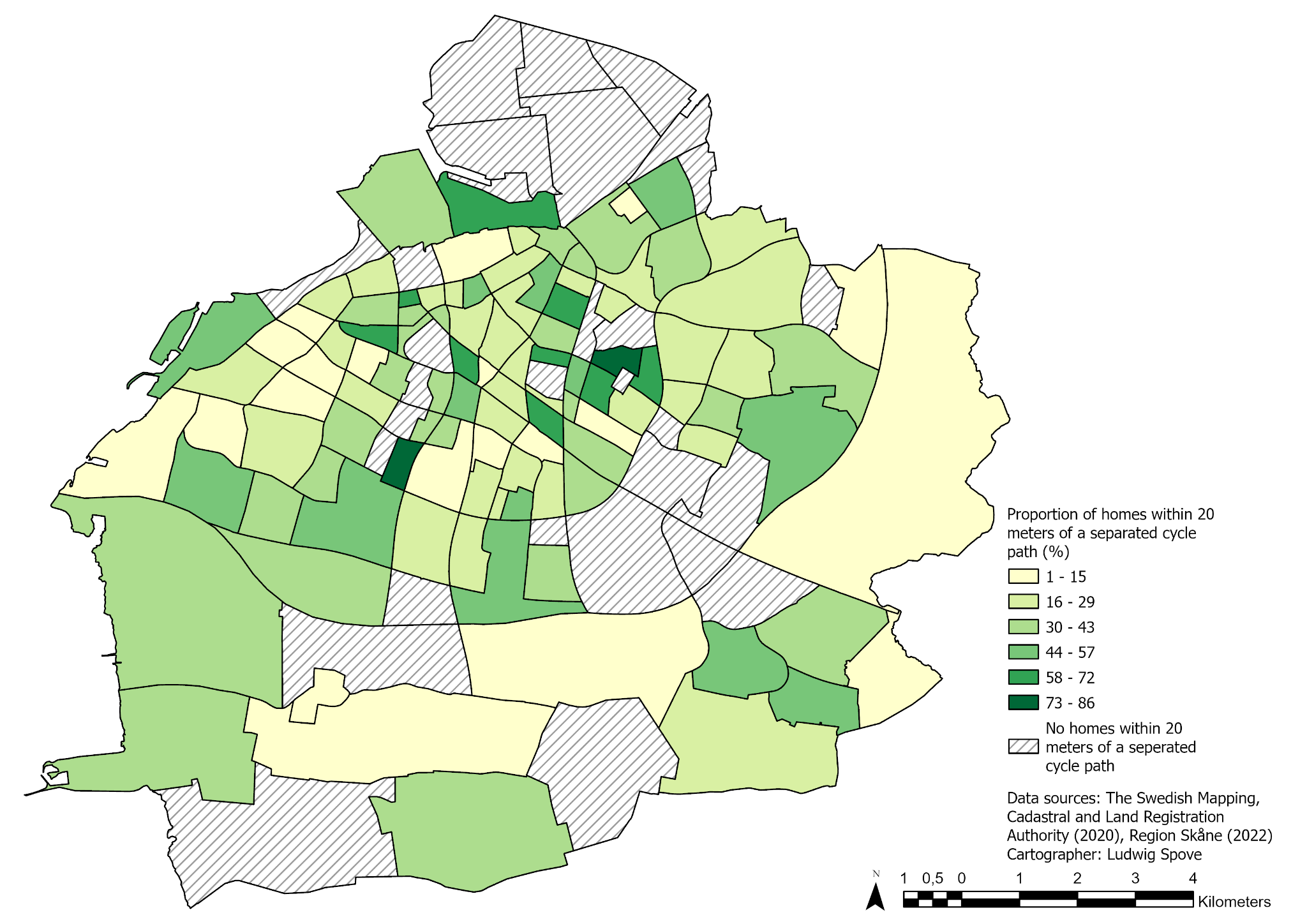
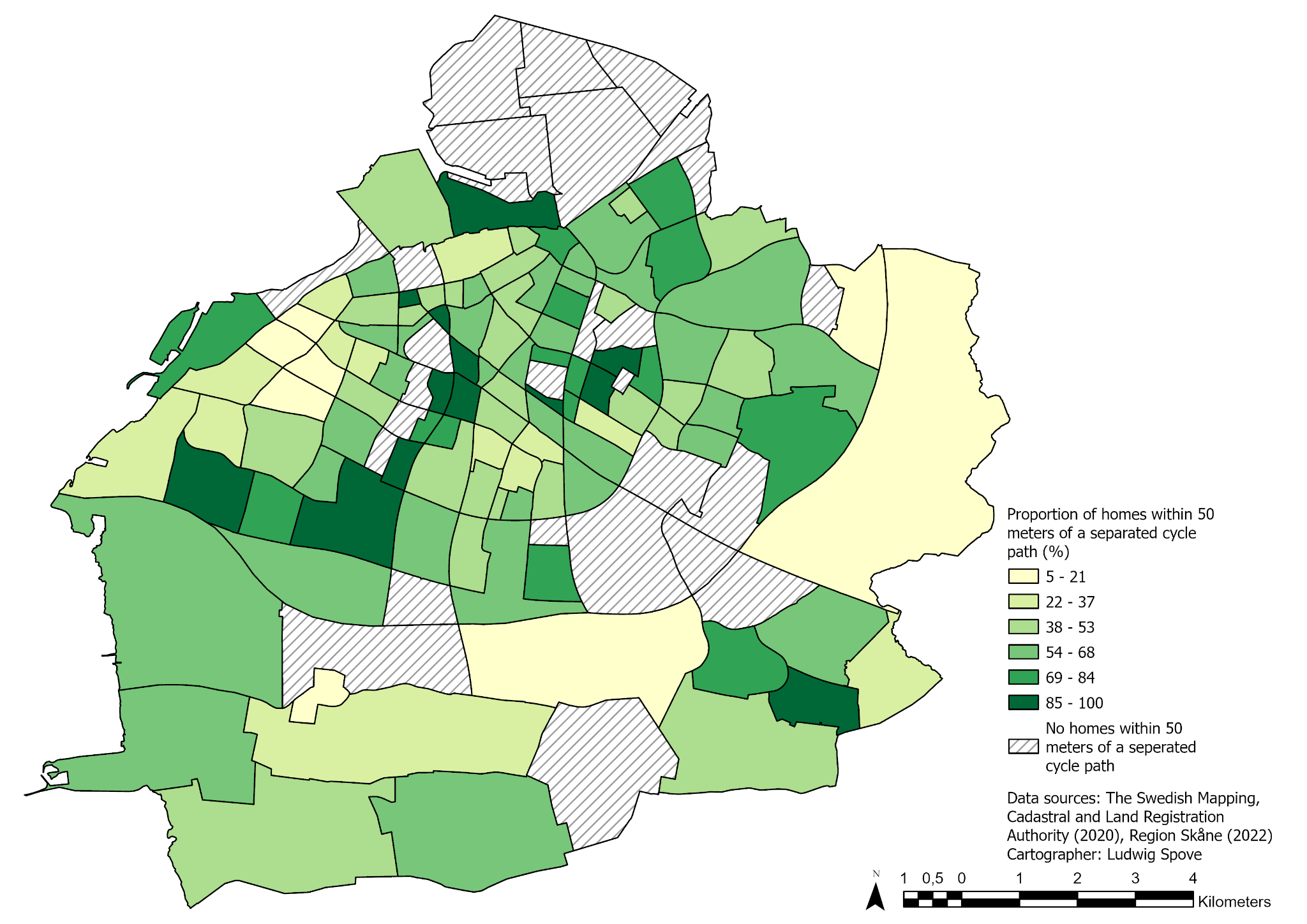
What struck me wasn't only that GIS could analyze the entire cycling network in a relatively short time. It was that it allowed me to ask - and begin answering - a planning question that would have been cumbersome to explore only through other methods, such as observation and interviews. A key takeaway from the assignment was also of course not overreliance on only GIS analysis and thus the importance of observing real life situations as well. But nonetheless, from here I began to see how the software could be of use as a research method to be combined with qualitative methods such as observations, interviews, etc. and thus be incorporated into early workflows for urban planning.
Continued learning and sharing
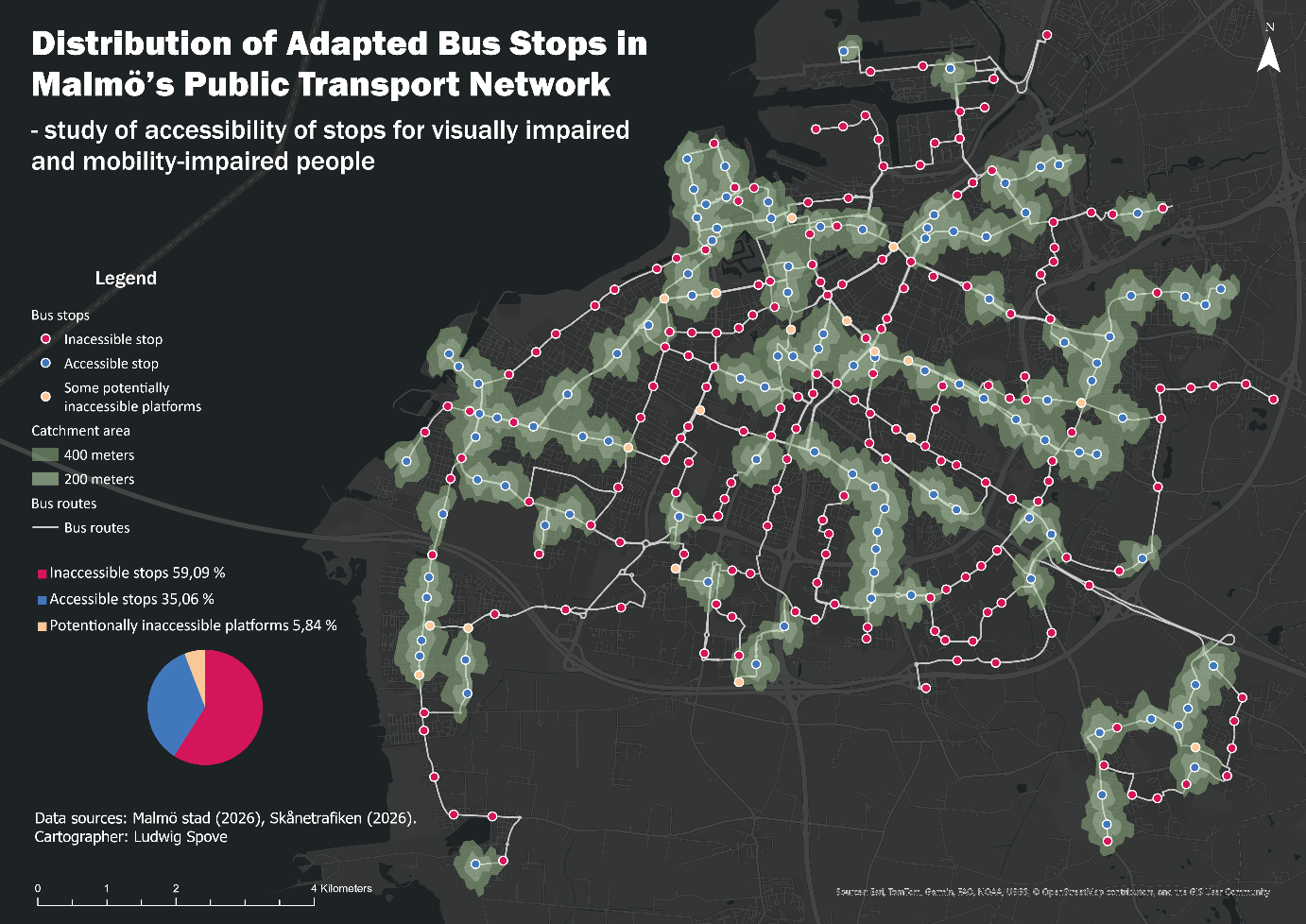
I didn't become interested in GIS because I wanted to become an expert in software. I became interested because I thought it could help me better understand cities. Today, when I encounter questions about, for example housing, accessibility, cycling infrastructure, or green spaces, my first instinct is often to wonder whether spatial analysis could reveal something that isn't immediately visible. This thinking has since led me to expand on some of my past assignments during my studies as personal GIS projects. Such as this one for example:
And as a student with no network, naturally, I dove into LinkedIn. At first, I was hesitant to post anything at all, but one teacher encouraged me to treat it as kind of a social media portfolio – where they thought my maps would be a great fit. I didn't start posting because I expected opportunities - I simply wanted to document what I was learning. Later, when I was reaching out for internship opportunities, one place told me that they had actually seen my posts which made them consider how I could fit into their projects.
Looking back, I realize that it wasn't GIS itself that shaped my journey - it was the curiosity that encouraged me to keep exploring it. Each step, from taking extra courses to helping classmates, tackling student projects, sharing projects online, and eventually securing an internship, grew naturally from that initial curiosity. GIS became more than another tool in my studies; it became the lens through which I began to explore cities and urban planning.
And if someone had told me during that introduction week that one short presentation on GIS would spark my interest and eventually steer me in a direction towards additional courses, late-night troubleshooting with classmates, exciting student urban planning projects, a growing professional network, and an internship, I probably wouldn't have believed them.
Perhaps, sometimes the most valuable opportunities begin by simply following your curiosity.
Now, in the middle of my master studies, I have continued doing extra GIS courses, including Esri MOOC courses, and in a recent project I worked with mapping and quantifying roof solar panel energy potential in two urban areas. And while talking about Esri MOOC courses, I highly recommend checking them out as they are free and provide you with an ArcGIS pro license during the course, which is a fantastic opportunity for us on student budgets to get a closer look at and time to experiment with professional software! And as a final note, I’d encourage you to allow yourself to be curious about GIS and give yourself time to learn!
If you have questions or simply want to connect, add me on LinkedIn or send me an email at stud-spove@ruc.dk




