The vast majority of the maps I make have turnaround times that mean almost all of the labeling I do has to be fully automated, using Maplex. Any solution that requires me to manually create a label as a text item or convert a set of labels to graphics/etc. increases my turnaround too much for the constraints I have to meet.
For most things, Maplex is sufficient for "good enough" labels in the projects I have, but it really seems to struggle with high-sinuosity feature classes, even at zoom levels where that sinuosity is functionally irrelevant.
Case A (Maplex "Centered curved", ArcGIS Pro 3.1.3):
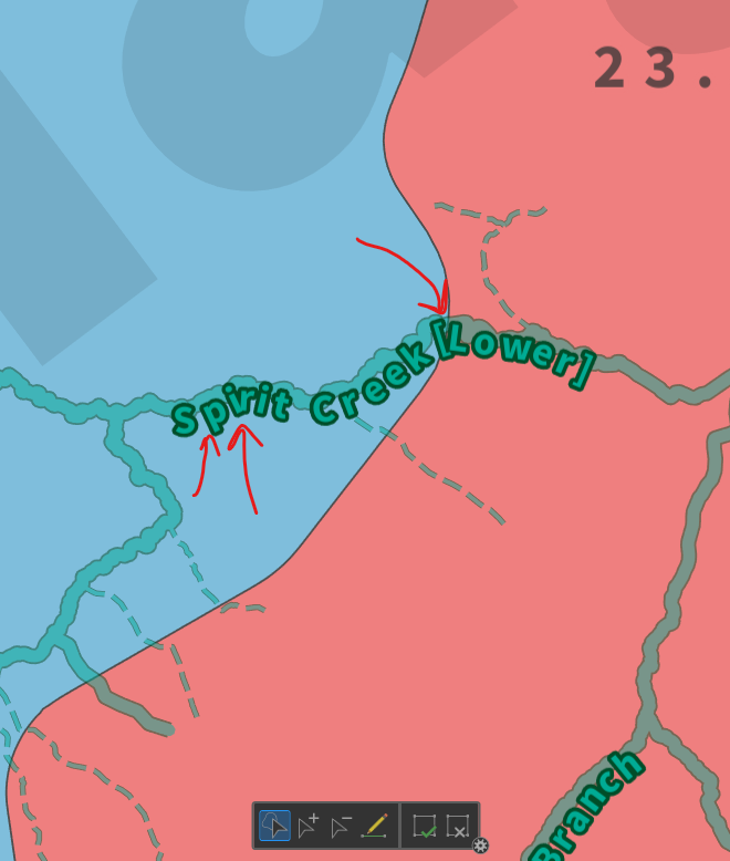
Note the areas indicated by red arrows. Maplex results in excess kerning between the "S" and "p" of "Spirit", while the "i" and "r" of the same word, and the "[" and "L" later in the label crash together in an unsightly mess. All three of those locations are cases where there's a sharper cut in the geometry of the stream centerline that the label is trying to follow. As a sidenote, the centerline geometry in question is made up exclusively of straight subsegments; there are no true/bezier curves.
As an alternative, I could select "Centered straight" for my labels, but that takes the issue too far towards the opposite end of the spectrum and often looks incredibly odd for riverine features.
Case B (Manual):
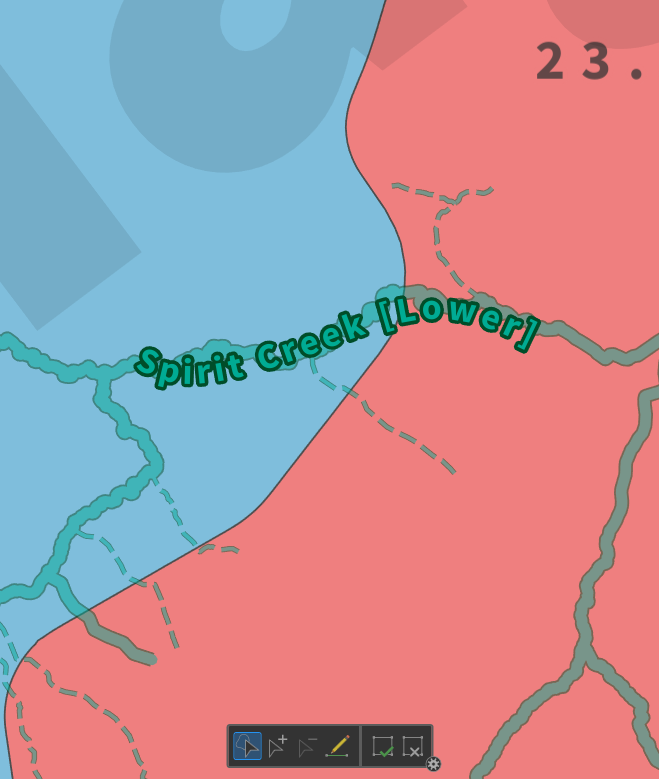
This label was made with a text element added in the Layout view, and has only 3 vertices to control the bezier curves, and we can see that the kerning between individual characters is quite a bit better.
Related Perspective/Use Case 1:
In addition to using labels as finished products in an output map, I also use them as sort of a heads-up-display of selected information about a feature, when I'm doing more complex editing of data. In these cases, I never even create a Layout; everything is done in Map View. In addition, the extra labor to create manual labels would negate the efficiencies created by that HUD approach to data review/intake.
Related Perspective/Use Case 2:
When producing a Map Series with a large volume of individual maps, manual creation or editing of labels is an unrealistic burden, and yet any increased variation in scale between the maps increases the likelihood of kerning errors and an inferior map product.
Suggested Improvement:
Add a "maximum sinuosity" parameter to the Centered curved and Offset curved label placements. Features with greater sinuosity than the indicated value would essentially round the sinuosity down to that maximum on-the-fly, for the purposes of determining label placement.
Alternately, the parameter could reference average sinuosity over the portion of the feature covered by the label. This would cause a feature with many rapid curves to be averaged out to a central throughline, like finding a "best fit" line on a statistical line graph.