When loading the meta-data for a map service using LoadAllLayersAndTables we see this error:
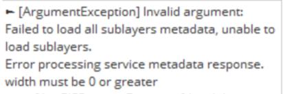
After digging around in the service's meta data for several hours, we discovered the issue was with the line width of one of the layers. For some odd reason, it had been published with a negative width. Not sure how that is possible, but the main concern for me is this error message. It is terrible at communicating information that would allow the user to figure out the problem. No layer names, no information about symbology. Lots of repetition of metadata and sublayers and "width must be 0 or greater". We don't even know what "width" it is talking about.
Sorry to rant, but this method call is so broad (loading all meta data from a map service), it needs to be specific about the layer, field, renderer, or any other part of the JSON it was parsing when it encountered the error. Please add this as soon as possible for this error. And please consider adding at least the layer name to all such errors that are possible while parsing service meta-data. Thank you!

