Hi all, I'm needing your help once again with a code/script tool that I have been working on.
import arcpy
import os

arcpy.env.overwriteOutput = True

arcpy.env.workspace =  r"C:\UpdateDevelopmentPython\ForDeveloping\ForDeveloping.gdb"
EnterWaterSysID = arcpy.GetParameterAsText(0).split(";")
Hydrant_FC = "Hydrants"
WaterSystems = "WaterSystems"
Streetmap = r"C:\UpdateDevelopmentPython\Streetmap Premium\FGDB\StreetMap_Data\NorthAmerica.gdb\Routing\Routing_ND"


qry = "{0} IN ({1})".format(arcpy.AddFieldDelimiters(datasource= Hydrant_FC, field = 'WaterSysID'), ', '.join(EnterWaterSysID))

arcpy.SelectLayerByAttribute_management(in_layer_or_view=Hydrant_FC, where_clause=qry)
arcpy.SelectLayerByLocation_management(Hydrant_FC,"Within",WaterSystems,None,"SUBSET_SELECTION","INVERT")

arcpy.env.workspace = r"C:\UpdateDevelopmentPython\ForDeveloping\ForDeveloping.gdb"
Service_Area = arcpy.na.MakeServiceAreaAnalysisLayer(network_data_source=Streetmap,
                                                       layer_name="Service Area",
                                                       travel_mode="Driving Distance",
                                                       travel_direction="FROM_FACILITIES",
                                                       cutoffs=[0.189394],
                                                       time_of_day="",
                                                       time_zone="LOCAL_TIME_AT_LOCATIONS",
                                                       output_type="LINES",
                                                       polygon_detail="STANDARD",
                                                       geometry_at_overlaps="SPLIT",
                                                       geometry_at_cutoffs="RINGS",
                                                       polygon_trim_distance="100 Meters",
                                                       exclude_sources_from_polygon_generation=[],
                                                       accumulate_attributes=["Miles"],
                                                       ignore_invalid_locations="SKIP")[0]

Updated_Service_Area = arcpy.na.AddLocations(in_network_analysis_layer=Service_Area,
                                             sub_layer="Facilities",
                                             in_table=Hydrant_FC,
                                             field_mappings="",
                                             search_tolerance="5000 Meters",
                                             sort_field="",
                                             search_criteria=[["Routing_Streets", "SHAPE"],
                                                             ["Routing_Streets_Override", "NONE"],
                                                             ["Routing_ND_Junctions", "NONE"]],
                                             match_type="MATCH_TO_CLOSEST",
                                             append="APPEND",
                                             snap_to_position_along_network="NO_SNAP",
                                             snap_offset="5 Meters",
                                             exclude_restricted_elements="EXCLUDE",
                                             search_query=[])[0]

Solve_Succeeded = arcpy.na.Solve(in_network_analysis_layer=Updated_Service_Area,
                                 ignore_invalids="SKIP",
                                 terminate_on_solve_error="TERMINATE",
                                 simplification_tolerance="",
                                 overrides="")

Lines = arcpy.Select_analysis("Lines","Lines_Selected")

arcpy.SelectLayerByAttribute_management(Hydrant_FC, "CLEAR_SELECTION")

Lines_Extracted = r"C:\UpdateDevelopmentPython\ForDeveloping\ForDeveloping.gdb\Lines_Selected"
p = arcpy.mp.ArcGISProject("CURRENT")
m = p.listMaps("Map")[0]
m.addDataFromPath(Lines_Extracted)

NewHydrantLines = arcpy.MakeFeatureLayer_management(Lines_Extracted,"HydrantLines")
outgdb = r"C:\UpdateDevelopmentPython\ForDeveloping\ForDeveloping.gdb\Lines_Selected_Joined"

arcpy.analysis.SpatialJoin("Lines_Selected",
                           "Hydrants",
                           outgdb,
                           "JOIN_ONE_TO_ONE",
                           "KEEP_COMMON",
                           'WaterSysID "WaterSysID" true true false 4 Long 0 0,First,#,Hydrants,WaterSysID,-1,-1',
                           "WITHIN_A_DISTANCE",
                           "1000 Feet", '')

Streets_Joined = r"C:\UpdateDevelopmentPython\ForDeveloping\ForDeveloping.gdb\Lines_Selected_Joined"
fieldName = "WaterSysID"
delimfield = arcpy.AddFieldDelimiters(Streets_Joined,fieldName)
sql = delimfield = EnterWaterSysID
with arcpy.da.SearchCursor(Streets_Joined,fieldName) as cursor:
    for row in cursor:
arcpy.SelectLayerByAttribute_management(row,"NEW_SELECTION",sql)After I perform the spatial join which is line 69 of my code I get an feature class called Lines_Selected_Joined with an attribute table that looks like the following.
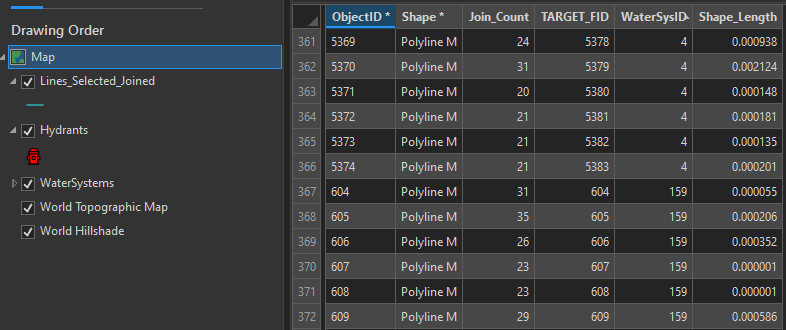
This works great but now what I'm trying to do is generate individual feature classes based on the unique values found in the WaterSysID column.
The WaterSysID values that I want to extract from this one feature class should be the same ones that I enter in the tool using the GetParameterAsText function, found on line 7 of my code. In this case it would be for WaterSysIDs 4 and 159.
 Any suggestions on how to go about this? Thanks all in advance for the help, I do appreciate it as I'm pretty green when it comes to Python.


