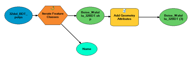
Hi All - I just got back from the ESRI Users Conference jazzed up to use ModelBuilder to streamline my workflow. Of course everything worked beautifully in the demos, and now back in my office....
I would like to calculate the area in square miles for a whole bunch of shapefiles, and Im trying to use the Add Geometry Attributes tool. I loaded all my shapefiles into a feature class (called 32dol_BDT_polys), and as you can see in the figure, my output from Iterate Feature Classes is the first shapefile in the folder, not the entire list of shapefiles. I tried this with my input as a geodatabase and the same thing happened.
Ive also tried this with every other iterate tool and had no luck there either.
Please help.