I'm working on manipulating point coordinates into line segments. I have a series of GPS track points that I'm trying to get into individual links. Each line will only have a starting vertex and and ending vertex. I was successful in loading each point, starting with the second point, in copying the X,Y coordinates from the prior point. For example, point 2 has its GPS location in and X and Y column and it has the coordinate from point 1 in two other X and Y columns, point 3 has its X,Y values and the values from point 2. This has given me both the starting and ending coordinates.
I tried using the sample Python script from the help file, but it seems to skip segments. The only thing I can think is happening is that the X1 and Y1 and loading in as the same as X2 and Y2, so there is no line to be drawn, yet a feature is created. The other problem I've run into is that the vertices of the lines don't overlap the points.
mxd = arcpy.mapping.MapDocument("Current")# Define mxd to current file.


mapLyr1 = arcpy.mapping.ListLayers(mxd, "test_points") [0]


feature_info = list()


with arcpy.da.UpdateCursor(mapLyr1,["FID","Latitude", "Longitude", "E_Lat", "E_Long"]) as sCursor:
    for row in sCursor:
  if row[0] == 0:
  lastLat = row[1]
  lastLong = row[2]
  else:
  thisLat = row[1]
  thisLong = row[2]
  row[3] = lastLat
  row[4] = lastLong
  sCursor.updateRow(row)
  Coords = [[thisLong, thisLat], [lastLong, lastLat]]#creates the X1, Y1 and X2, Y2 pairs
  print Coords
  feature_info.append(Coords)#append the X,Y pairs
  lastLat = thisLat#turn current Y value into past Y value
  lastLong = thisLong#turn current X value into past X value


#Loops through layer to create list of X,Y Pairs
with arcpy.da.SearchCursor(mapLyr1, ["Longitude", "Latitude", "E_Long", "E_Lat"]) as lineMaker:
  for points in lineMaker:
  p1, p2, p3, p4 = points[0], points[1], points[2], points[3]
  pairs = [[p1, p2], [p3, p4]]
  feature_info.append(pairs)


features = []
#Snippet from Help/ESRI Resources
for feature in feature_info:
    # Create a Polyline object based on the array of points
    # Append to the list of Polyline objects
    features.append(
        arcpy.Polyline(
            arcpy.Array([arcpy.Point(*coords) for coords in feature])))


# Persist a copy of the Polyline objects using CopyFeatures
arcpy.CopyFeatures_management(features, "c:/temp/polylines.shp")I end up with the features looking like this:
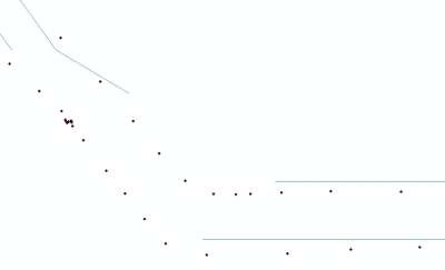
I'm not sure if this is a scripting error alone, or if projections are playing a part too. If it were a projection issue, then all the lines would show up. I expect that if it were only a scripting error, all the points and lines would coincide.




