I have a layer, water_pipe. I am creating a feature layer in the arcgis javascript api, and when the feature layer loads, it give the error "cannot execute query" in the network logs.
The query string parameters look like this:
f:
json
returnGeometry:
true
spatialRel:
esriSpatialRelIntersects
maxAllowableOffset:
1
geometry:
{"xmin":-10384451.501584552,"ymin":5510511.210446009,"xmax":-10383876.812244719,"ymax":5511085.899785845,"spatialReference":{"wkid":102100,"latestWkid":3857}}
geometryType:
esriGeometryEnvelope
inSR:
102100
outFields:
*
outSR:
102100
token:
<token>
On the server logs, the above error message is given.
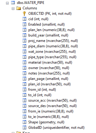
Geodatabase error: Only one spatial column is supported in this operation [gis.DBO.water_pipe][STATE_ID = 1447].
There is only one Shape column, here is a screenshot from the sql server manager:
Any suggestions on what I can do to fix this?




