I have a collection of about 1300 points and for each point I want to get the average of a raster layer within a 50 m buffer. I have overlapping polygons. I've been scouring the forums for days now and I still haven't been able to come up with a solution that works. Here's an idea of what my data looks like
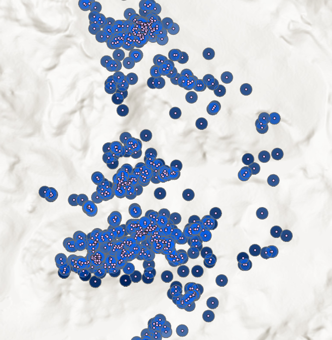
My current workflow is to to run Zonal Statistics as Table, digest it into a dictionary, and then use that to populate a field in my buffer layer. The following is my code (modified from something I found on a forum):
out <SPAN class="operator token">=</SPAN> output workspace
features <SPAN class="operator token">=</SPAN> arcpy<SPAN class="punctuation token">.</SPAN>Buffer_analysis<SPAN class="punctuation token">(</SPAN>pointfc<SPAN class="punctuation token">,</SPAN> out <SPAN class="operator token">+</SPAN> <SPAN class="string token">'\\name'</SPAN><SPAN class="punctuation token">,</SPAN> <SPAN class="string token">'50 Meters'</SPAN><SPAN class="punctuation token">)</SPAN>
zone_field <SPAN class="operator token">=</SPAN> <SPAN class="string token">"OBJECTID"</SPAN>
input_raster <SPAN class="operator token">=</SPAN> raster file
field_name <SPAN class="operator token">=</SPAN> <SPAN class="string token">"Average"</SPAN>
field_type <SPAN class="operator token">=</SPAN> <SPAN class="string token">"DOUBLE"</SPAN>
stat <SPAN class="operator token">=</SPAN> <SPAN class="string token">"MEAN"</SPAN>
<SPAN class="keyword token">import</SPAN> arcpy
<SPAN class="keyword token">from</SPAN> arcpy<SPAN class="punctuation token">.</SPAN>sa <SPAN class="keyword token">import</SPAN> <SPAN class="operator token">*</SPAN>
<SPAN class="comment token"># Add zone field to features</SPAN>
arcpy<SPAN class="punctuation token">.</SPAN>AddField_management<SPAN class="punctuation token">(</SPAN>features<SPAN class="punctuation token">,</SPAN> field_name<SPAN class="punctuation token">,</SPAN> field_type<SPAN class="punctuation token">)</SPAN>
<SPAN class="comment token"># Clear path for temporary table</SPAN>
<SPAN class="keyword token">if</SPAN> arcpy<SPAN class="punctuation token">.</SPAN>Exists<SPAN class="punctuation token">(</SPAN><SPAN class="string token">"zonal_table"</SPAN><SPAN class="punctuation token">)</SPAN><SPAN class="punctuation token">:</SPAN>
<SPAN class="keyword token">try</SPAN><SPAN class="punctuation token">:</SPAN>
arcpy<SPAN class="punctuation token">.</SPAN>Delete_management<SPAN class="punctuation token">(</SPAN><SPAN class="string token">"zonal_table"</SPAN><SPAN class="punctuation token">)</SPAN>
<SPAN class="keyword token">except</SPAN><SPAN class="punctuation token">:</SPAN>
arcpy<SPAN class="punctuation token">.</SPAN>AddError<SPAN class="punctuation token">(</SPAN><SPAN class="string token">"Unable to clear temp table"</SPAN><SPAN class="punctuation token">)</SPAN>
sys<SPAN class="punctuation token">.</SPAN>exit<SPAN class="punctuation token">(</SPAN><SPAN class="operator token">-</SPAN><SPAN class="number token">1</SPAN><SPAN class="punctuation token">)</SPAN>
<SPAN class="comment token"># Zonal statistics</SPAN>
<SPAN class="keyword token">print</SPAN><SPAN class="punctuation token">(</SPAN><SPAN class="string token">"Performing zonal statistics: "</SPAN> <SPAN class="operator token">+</SPAN> field_name<SPAN class="punctuation token">)</SPAN>
zonal_table <SPAN class="operator token">=</SPAN> ZonalStatisticsAsTable<SPAN class="punctuation token">(</SPAN>features<SPAN class="punctuation token">,</SPAN>zone_field<SPAN class="punctuation token">,</SPAN> input_raster<SPAN class="punctuation token">,</SPAN> out <SPAN class="operator token">+</SPAN> <SPAN class="string token">"\\zonal_table"</SPAN><SPAN class="punctuation token">,</SPAN> <SPAN class="string token">"DATA"</SPAN><SPAN class="punctuation token">,</SPAN> stat<SPAN class="punctuation token">)</SPAN>
<SPAN class="comment token"># Digest statistics from zonal_table</SPAN>
<SPAN class="keyword token">print</SPAN><SPAN class="punctuation token">(</SPAN><SPAN class="string token">"Digesting "</SPAN> <SPAN class="operator token">+</SPAN> stat <SPAN class="operator token">+</SPAN> <SPAN class="string token">" from zonal table"</SPAN><SPAN class="punctuation token">)</SPAN>
stat_dict <SPAN class="operator token">=</SPAN> <SPAN class="punctuation token">{</SPAN><SPAN class="punctuation token">}</SPAN>
<SPAN class="keyword token">with</SPAN> arcpy<SPAN class="punctuation token">.</SPAN>da<SPAN class="punctuation token">.</SPAN>SearchCursor<SPAN class="punctuation token">(</SPAN>zonal_table<SPAN class="punctuation token">,</SPAN><SPAN class="punctuation token">[</SPAN>zone_field<SPAN class="punctuation token">,</SPAN>stat<SPAN class="punctuation token">]</SPAN><SPAN class="punctuation token">)</SPAN> <SPAN class="keyword token">as</SPAN> cursor<SPAN class="punctuation token">:</SPAN>
<SPAN class="keyword token">for</SPAN> row <SPAN class="keyword token">in</SPAN> cursor<SPAN class="punctuation token">:</SPAN>
stat_dict<SPAN class="punctuation token">[</SPAN>row<SPAN class="punctuation token">[</SPAN><SPAN class="number token">0</SPAN><SPAN class="punctuation token">]</SPAN><SPAN class="punctuation token">]</SPAN> <SPAN class="operator token">=</SPAN> row<SPAN class="punctuation token">[</SPAN><SPAN class="number token">1</SPAN><SPAN class="punctuation token">]</SPAN>
<SPAN class="keyword token">print</SPAN><SPAN class="punctuation token">(</SPAN><SPAN class="string token">"dictionary done"</SPAN><SPAN class="punctuation token">)</SPAN>
<SPAN class="comment token"># update new field in feature class</SPAN>
<SPAN class="keyword token">print</SPAN><SPAN class="punctuation token">(</SPAN><SPAN class="string token">"updating field"</SPAN><SPAN class="punctuation token">)</SPAN>
arcpy<SPAN class="punctuation token">.</SPAN>AddMessage<SPAN class="punctuation token">(</SPAN><SPAN class="string token">"Calculating "</SPAN> <SPAN class="operator token">+</SPAN> field_name<SPAN class="punctuation token">)</SPAN>
<SPAN class="keyword token">with</SPAN> arcpy<SPAN class="punctuation token">.</SPAN>da<SPAN class="punctuation token">.</SPAN>UpdateCursor<SPAN class="punctuation token">(</SPAN>features<SPAN class="punctuation token">,</SPAN> <SPAN class="punctuation token">[</SPAN>zone_field<SPAN class="punctuation token">,</SPAN> field_name<SPAN class="punctuation token">]</SPAN><SPAN class="punctuation token">)</SPAN> <SPAN class="keyword token">as</SPAN> cursor2<SPAN class="punctuation token">:</SPAN>
<SPAN class="keyword token">for</SPAN> row2 <SPAN class="keyword token">in</SPAN> cursor2<SPAN class="punctuation token">:</SPAN>
row2<SPAN class="punctuation token">[</SPAN><SPAN class="number token">1</SPAN><SPAN class="punctuation token">]</SPAN> <SPAN class="operator token">=</SPAN> stat_dict<SPAN class="punctuation token">[</SPAN>row2<SPAN class="punctuation token">[</SPAN><SPAN class="number token">0</SPAN><SPAN class="punctuation token">]</SPAN><SPAN class="punctuation token">]</SPAN>
cursor2<SPAN class="punctuation token">.</SPAN>updateRow<SPAN class="punctuation token">(</SPAN>row2<SPAN class="punctuation token">)</SPAN><SPAN class="line-numbers-rows"><SPAN></SPAN><SPAN></SPAN><SPAN></SPAN><SPAN></SPAN><SPAN></SPAN><SPAN></SPAN><SPAN></SPAN><SPAN></SPAN><SPAN></SPAN><SPAN></SPAN><SPAN></SPAN><SPAN></SPAN><SPAN></SPAN><SPAN></SPAN><SPAN></SPAN><SPAN></SPAN><SPAN></SPAN><SPAN></SPAN><SPAN></SPAN><SPAN></SPAN><SPAN></SPAN><SPAN></SPAN><SPAN></SPAN><SPAN></SPAN><SPAN></SPAN><SPAN></SPAN><SPAN></SPAN><SPAN></SPAN><SPAN></SPAN><SPAN></SPAN><SPAN></SPAN><SPAN></SPAN><SPAN></SPAN><SPAN></SPAN><SPAN></SPAN><SPAN></SPAN><SPAN></SPAN><SPAN></SPAN><SPAN></SPAN><SPAN></SPAN><SPAN></SPAN><SPAN></SPAN><SPAN></SPAN><SPAN></SPAN><SPAN></SPAN><SPAN></SPAN><SPAN></SPAN><SPAN></SPAN><SPAN></SPAN></SPAN>The process works; however, my results are mostly different than what I get from running Zonal Statistics and comparing the point to the underlying raster. All of my data is in the same projected coordinate system. I've seen that there are issues with the way the snap rasters are implemented and have tried converting my buffer to raster (outside of the code on a small subset to test) without any better results. I also saw that the underlying bug was resolved in 10.5, but I still have differing results between Zonal Statistics and Zonal Statistics as Table in both 10.6 and ArcPro 2.3.
Is the issue with the Zonal Statistics or the Zonal Statistics as Table tool? Or is there another hole in my workflow somewhere I'm not considering? I'm about out of stuff to check, so any ideas are greatly appreciated.



