Educational environments are becoming increasingly complex. Multiple buildings, multiple floors, increasing amenities, and shared services to manage. Combined with a constantly changing population of students, educators and visitors, these factors create daily operational challenges. There are also fiscal considerations tied to budgetary constraints, facility and asset management operations, and other direct costs further impact each agency’s ability to provide services effectively. For organizations such as the Delaware County Intermediate Unit (DCIU), a regional educational service agency supporting school districts across Delaware County, Pennsylvania, clear visibility into their facilities is critical.
To address these challenges, DCIU has embraced ArcGIS Indoors to create a more efficient, informed, and connected educational environment.
About the Delaware County Intermediate Unit
DCIU is a regional educational service agency established in 1970 to support public, private, and charter schools across the County by delivering shared, cost-effective programs that enhance instructional quality, operational efficiency, and student outcomes. DCIU provides a comprehensive portfolio of over 50 programs spanning early childhood through adult education, with a strong emphasis on special education, career and technical education, and workforce development initiatives.
DCIU’s programs also provide early intervention and Head Start services, specialized K–12 special education programs, and transition initiatives that support employment and independent living. Collectively, these programs and services position DCIU as a centralized collaborative resource that enables local school districts to access specialized expertise, comply with state and federal mandates, and deliver high-quality, equitable educational opportunities across the region.
The Problem
DCIU faced the common challenges of most educational institutions: navigating large multi floor facilities dispersed across the county, inaccessible digital floor plans, asset blindness, and resource utilization. A challenge unique to DCIU was a constantly shifting student body population which must adhere to specific program requirements, such as student/teacher ratios, teacher assistant/student ratios, room capacity, and half/full day instruction. This also includes room-based resources, amenities, and learning tools, such as smart boards, hands-on learning materials, and sensory tools, to support specific programs and legal guidelines.
The balancing of students, teachers, and resources was an entirely spreadsheet and paper-based process. This manual coordination process had reached its maximum efficiency and was becoming an increasingly time-consuming. Traditional floor plans and static diagrams were no longer sufficient. DCIU needed a dynamic, authoritative, digital indoor mapping solution that could meet their current needs and evolve with their facilities while supporting daily operations and long-term planning.
The Solution
DCIU required a facility and operations resource management platform that was more data-driven, provided actionable insight, and gave them visibility across all of their facilities. By leveraging ArcGIS Indoors, DCIU is establishing a floor-aware indoor GIS system that has and will allow them to:
- Create standardized, interactive, floor-aware indoor maps accessible to all staff members across their 8 facility locations totaling 800,000 square feet.
- Visualize student, teacher, teaching assistant, and school scheduling information for each room. This includes specific educational program details such as student/teacher ratios and room capacity information parameters which are defined by users within the software.
- Interact with existing assets (water heaters, generators, pumps, electrical panels, cameras) across all facilities for facility and asset management purposes and deployment and management of maintenance resources.
- Perform more in-depth and spatially accurate asset inventories for recently renovated and expanded facilities to increase operational efficiencies.
- Extend platform capabilities and functionality into new and existing workflows such as calculating more precise individual and shared program costs by square footage.
- Conduct future planning scenarios and budgetary analysis while assessing current performance.
As DCIU began exploring the capabilities of indoor mapping, the organization quickly realized that successfully implementing an indoor mapping platform required specialized expertise beyond traditional CAD and GIS workflows. Recognizing the complexity of standardizing decades of facility data and integrating it into an indoor mapping solution, DCIU partnered with T&M Associates, an Esri Gold Level partner with expertise in indoor mapping implementations.
T&M began by converting existing CAD files, produced by the same vendor over the last 20+years, into the ArcGIS Indoors Information Model. As is common with long-term CAD datasets, the files varied significantly in quality, consistency, and spatial accuracy. Combined with ongoing construction projects and facility room renumbering efforts, the processing and standardization of the data became a highly iterative collaboration between T&M’s CAD and GIS teams. A critical component of the project is ensuring that room information remains accurate and synchronized across all DCIU systems while continuous facility updates were occurring.
T&M then set up an ArcGIS Online organization with ArcGIS Indoors to provide a facility and operations resource management platform for DCIU to leverage. Initial focus was on establishing consistent room naming conventions, space use classifications, accurate exit/entrance locations, and other functional data standards to support the indoor mapping platform. This effort combined information extracted from existing CAD floor plans with institutional knowledge provided by DCIU staff to support day-to-day operations. While this created a strong baseline for the platform, DCIU’s operational and planning needs extended far beyond static floor plan information.
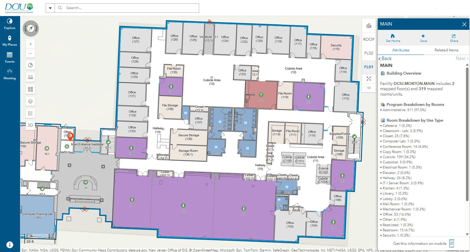
Figure 1: DCIU Indoors Viewer Application
To support operational needs, focus shifted to student, teacher, and scheduling information across all facilities which changed daily and were managed in separate systems. T&M started with key school programs (Early Intervention, Head Start, Special Education) that required special rules and workflows required by law. These requirements included minimum, maximum, and target room capacities for AM, PM and full-day students; room budget targets with minimum, maximum, and targeted numbers; individual student room capacities; fire marshal room capacities; and teacher’s assistant requirements. T&M then partnered with DCIU technical IT staff to develop data feeds for student, teacher, and scheduling information from their internal systems that are ingested into ArcGIS Online daily. This data will support legal compliance and operational decision-making.
Having been in the GIS industry for 30 years, the best part of my job is still when a client gets to see their data spatially for the first time and the ideas start to flow…. and DCIU did not disappoint! Visualizing their data in a dynamic environment immediately sparked discussions around future enhancements, including the ability to monitor real-time attendance and scheduling updates as they occur each morning. More importantly, the platform enabled DCIU to view and analyze their information in entirely new ways. As a result, we were able to identify gaps in data that needed resolution before DCIU could begin to start utilizing the platform. Issues related to student, teacher, and scheduling data were addressed by DCIU in their systems. However, additional editing capabilities were required to update room information, school program capacity, room budget capacity, and other information that previously didn’t exist.
An application was created using ArcGIS Experience Builder to allow DCIU staff to update information contained and managed in ArcGIS Online. The DCIU Editing Dashboard provides staff with the ability to update room and resource information, room capacities, cost per square foot, room names, and descriptions. This allows them to create exceptions for known nuances in their data and facilities.
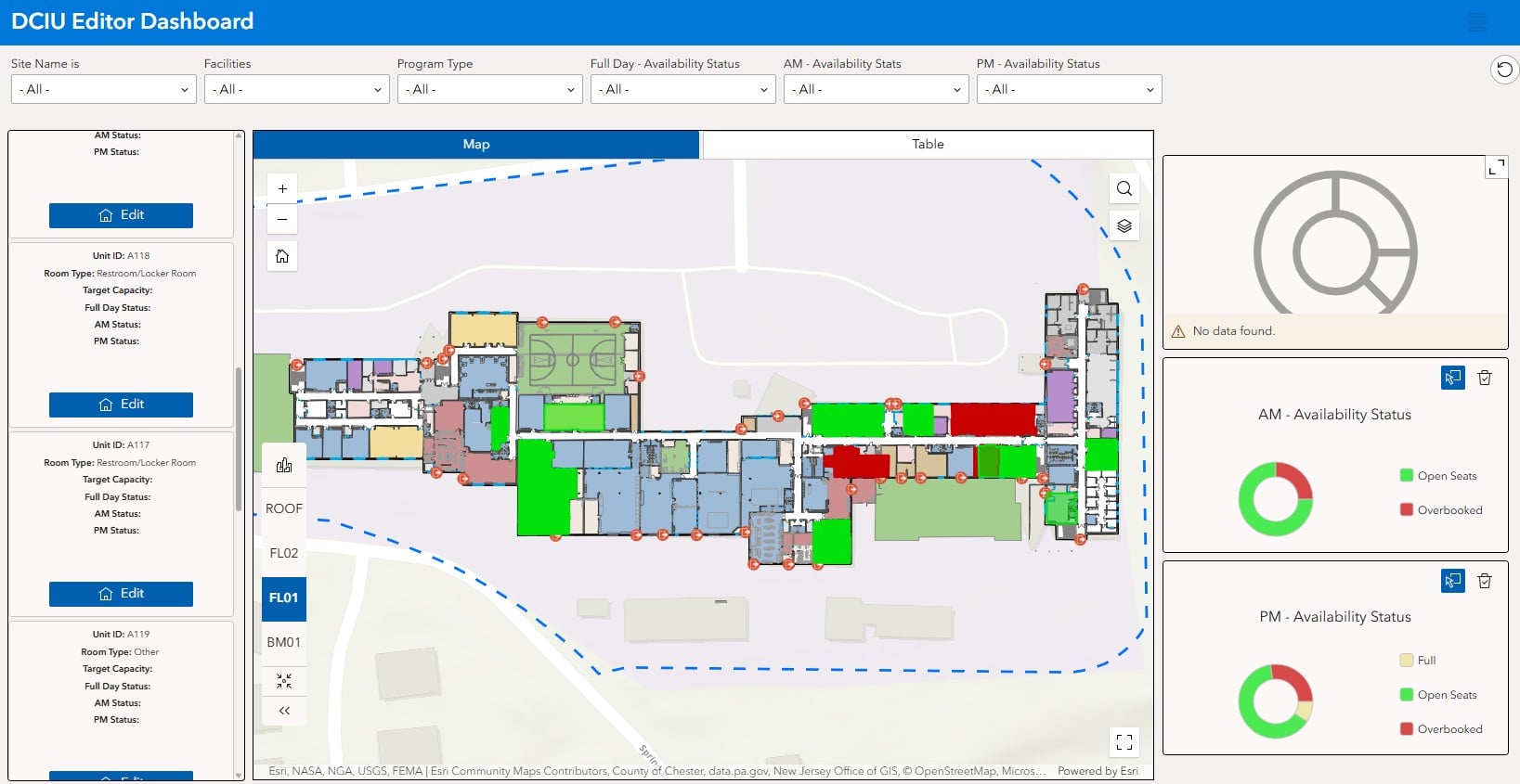
Figure 2: DCIU Editor Dashboard
T&M created additional Experience Builder applications to support the integration of DCIU’s video management system for precise camera placement and viewing as well as the renumbering of rooms for certain facilities. The partnership and collaboration with DCIU staff, who are actively working to update and maintain data, has led to increased visibility and adoption of the platform as it begins to be rolled out. Based on the number of “Can it do this?” questions we are getting, the future of indoor mapping at DCIU is bright!
Looking Ahead
With the project now at its midpoint, the next phase will focus on advancing the following key efforts:
- Finalization of the camera integration with ArcGIS Indoors as a new camera system has recently been deployed.
- Perform a full asset inventory of selected facilities with over 800 unique assets and integrating them with their historical asset management system. Portions of asset/facility management will now be performed in ArcGIS Online going forward.
- Visualization and progress tracking of facility-specific capital improvement projects and special initiatives requiring enhanced oversight and visibility.
- Implement school safety and security: evacuation routes, meeting/rally points, utility shut-offs, ingress/egress points, etc.
- Use AI to identify issues of concern based on established parameters and legal constraints.
About the Author and T&M Associates
T&M Associates is a leading engineering and technical services firm focused on innovative solutions that advance our clients’ goals and sustain communities. With 60 years of experience, we specialize in five key markets: Buildings and Facilities, Community and Land Development, Environmental, Transportation, and Water. Our team of technical experts and consultants consistently demonstrate success in achieving positive outcomes for our clients nationwide.
Grant Ervin is T&M’s Director of Applied Technology, bringing over 30 years of experience delivering innovative GIS and technology solutions for public and private sector clients. A certified GIS Professional (GISP), Grant has extensive experience supporting geospatial technology initiatives, data management, and enterprise solutions that help organizations modernize and improve operations and decision-making. Known for his strong leadership, technical expertise, and client-focused approach, Grant continues to guide organizations forward in leveraging GIS and asset management solutions to support long-term operational and infrastructure goals.
If you have any questions, drop a comment below or email me at gervin@tandmassociates.com
