Hello,
Recently I have been working on measuring the volume of some gravel piles in our gravel pits with drone imagery, but I have been coming across some oddities with using the Mensuration tools built into ArcGIS Pro (3.3.7 currently).
After creating a DSM, I am able to set that as the elevation and use it to measure volume with the mensuration tool with no problem, but if I switch out of the tool, when I return to use any of the 3D mensuration tools, I draw my polygon and then am met with an error as follows: "Transformation is unavailable for the current image." It gives me no further explanation and it keeps all my previous measurements in the results just fine.
About 75% of the time, restarting ArcGIS pro and reopening my project fixes this (after I again set the elevation data within mensuration options, another oddity that I have to do this every time I start the project) and I am once again able to make 3D mensuration measurements with no problem. The other 25% of the time it reverts back to the Transformation error.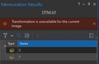
The Mensuration tool is new to me, and it seems like it is just finicky and maybe underdeveloped in favor of developing the capability in other programs like ArcGIS Reality, but if anyone has had this and was able to find a fix, that would be great.

