This is a recurring problem of mine: How do you easily tell if a feature class is part of a feature dataset or not?
It isn't an option in the Feature Class Properties, or in Describe Properties, or in Table Properties.
The best way I've found (unless I'm missing something very obvious, in which case I apologize to you all) is to just check the literal path of the feature class, e.g.:
z = [r"\\...\example.gdb\featDS\fc", r"\\...\example.gdb\fc"]
for x in z:
    if ".gdb" in x:
        y = x.split(".gdb")[1].split("\\")
        print(y)
        if len(y)>2:
            print("y is in a feature dataset")
        else:
            print("y is standalone")
#"y is in a feature dataset"
#"y is standalone"
This is kind of gross, you know?
I suppose I could also check out the path property ('path': '\\\\...\\exfgdb.gdb\\FD'), but then I still have to parse the dang thing to figure out how long it is. It's certainly more elegant than the code above, but it doesn't solve the problem of "I shouldn't have to work this hard".
I know that for the majority of geoprocessing, being in a feature dataset is immaterial to arcpy. That is, you can feed Buffer() both "\\...\ex.gdb\featDS\fc" and "\\...\ex.gdb\fc" and it'll work just fine.
That being said, there are times (e.g. replacing data sources) where you need to know whether you're in a feature dataset or not.
Please add in a property letting us do one of the following:
1) .isInFeatureDataset(): Boolean
2) .FeatureDataset(): Actual Feature Dataset name, defaults to None for Shapefiles, gdb feature classes outside a feature Dataset
or
3) Release an easy, surefire way for us to figure it out without parsing the path as a string.
See below for a sample of a real feature class that lives in a feature dataset called "FD". Other than reading the catalog path or the path properties and then parsing them, there isn't any clean way to get the feature dataset name.
print(arcpy.da.Describe(r"\\...\exfgdb.gdb\FD\inFD"))
{'catalogPath': '\\\\...\\exfgdb.gdb\\FD\\inFD',
                'FIDSet': None,
                'aliasName': '',
                'areaFieldName': '',
                'attributeRules': [],
                'baseName': 'inFD',
                'canVersion': False,
                'changeTracked': False,
                'children': [],
                'childrenExpanded': True,
                'createdAtFieldName': '',
                'creatorFieldName': '',
                'dataElementType': 'DEFeatureClass',
                'datasetType': 'FeatureClass',
                'dataType': 'FeatureClass',
                'defaultSubtypeCode': -1,
                'DSID': 4,
                'editedAtFieldName': '',
                'editorFieldName': '',
                'editorTrackingEnabled': False,
                'extension': '',
                'extensionProperties': {},
                'extent': <Extent object at ...>,
                'featureType': 'Simple',
                'fields': [<Field object at ...>,
                           <Field object at ...>,
                           <Field object at ...],
                'file': 'inFD',
                'fullPropsRetrieved': True,
                'geometryStorage': '',
                'globalIDFieldName': '',
                'hasGlobalID': False,
                'hasM': False,
                'hasOID': True,
                'hasSpatialIndex': True,
                'hasZ': True,
                'indexes': [<Index object at ...>,
                            <Index object at ...],
                'isCOGOEnabled': False,
                'isCompressed': False,
                'isTimeInUTC': True,
                'isVersioned': False,
                'lengthFieldName': 'Shape_Length',
                'metadataRetrieved': False,
                'MExtent': 'nan nan',
                'modelName': '',
                'name': 'inFD',
                'OIDFieldName': 'OBJECTID',
                'path': '\\\\...\\exfgdb.gdb\\FD',
                'rasterFieldName': '',
                'relationshipClassNames': [],
                'representations': [],
                'shapeFieldName': 'Shape',
                'shapeType': 'Polyline',
                'spatialReference': <SpatialReference object at ...>,
                'subtypeFieldName': '',
                'versionedView': '',
                'ZExtent': 'nan nan'
}
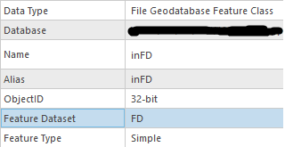
This is extra annoying because if you check out a feature layer's properties, it straight-up tells you that it's in a feature dataset: