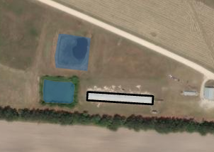
Hello everyone!
This may be a silly question but how would you go about this process?
I'm still relatively new to GIS and am currently tasked to "Create a unique ID for lagoon features (polygon) as well as to update the barn feature class (polygons) to list each associated lagoon's unique ID."
I've created the unique ID for the lagoons by creating a new field and calculating the field with the sequential number function, so that part is finished.
However, I'm stumped on the second half. I would think to relate the unique ID and go about that process but my boss is asking for me to spatially join them. I'm not well versed in spatial joining so any advice would be helpful.
Other information:
Lagoons (blue) = 2,544 polygons total
Barns (black) = 8,490 polygons total
There are in most cases more than one lagoon per farm (x number of barns).
None of them intersect, so it would have to be by a geodesic distance.