Greetings community,
Using ArcGIS Enterprise 10.8.1, I am attempting to ingest files containing sensor data. This data is generated by an external application in geojson format. I have attempted to use folder monitoring and polling an external website to retrieve the file, but it fails to generate events from the file.
A sample file is below:
{
	"type": "FeatureCollection",
	"features": [
		{
			"type": "Feature",
			"geometry": {
				"type": "Point",
				"coordinates": [
					"-85.585024",
					"36.097554",
					"957.0"
				]
			},
			"properties": {
				"project": "Real-Time Measurements",
				"affiliation": "Univ",
				"site": "FWR3-Site",
				"site_id": 7,
				"instrument": "Ditty-LTE",
				"instrument_id": 17,
				"measurements_in_file": 1,
				"data": [
					{
						"time": "2021-05-05T15:44:34Z",
						"test": "false",
						"vars": [
							{
								"variable_name": "WaterLevel1",
								"variable_shortname": "WL1",
								"units": "in.",
								"value": 109.05517999999999
							},
							{
								"variable_name": "Battery",
								"variable_shortname": "B",
								"units": "%",
								"value": 87.35
							},
							{
								"variable_name": "WaterLevel3",
								"variable_shortname": "WL3",
								"units": "in.",
								"value": 109.07
							},
							{
								"variable_name": "WaterLevel2",
								"variable_shortname": "WL2",
								"units": "in.",
								"value": 107.33103
							}
						]
					}
				]
			}
		}
	]
}It seems to have some difficulty creating a definition on its own. Even if I let it create the definition, events are not created. So I configured this geoevent definition:
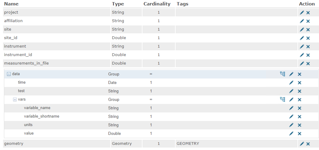
I enabled debug logging, and it seems that it is hanging up on parsing the file. I've attached that section of the log file, as well as a text version of the geojson file.
I've run out of things to check. Any ideas?
Thanks!
Brandon

