- Home
- :
- All Communities
- :
- Networks
- :
- Esri Young Professionals Network
- :
- Esri YPN Questions
- :
- Map Annotations with Arc Map or ArcGis Pro
- Subscribe to RSS Feed
- Mark Topic as New
- Mark Topic as Read
- Float this Topic for Current User
- Bookmark
- Subscribe
- Mute
- Printer Friendly Page
Map Annotations with Arc Map or ArcGis Pro
- Mark as New
- Bookmark
- Subscribe
- Mute
- Subscribe to RSS Feed
- Permalink
- Report Inappropriate Content
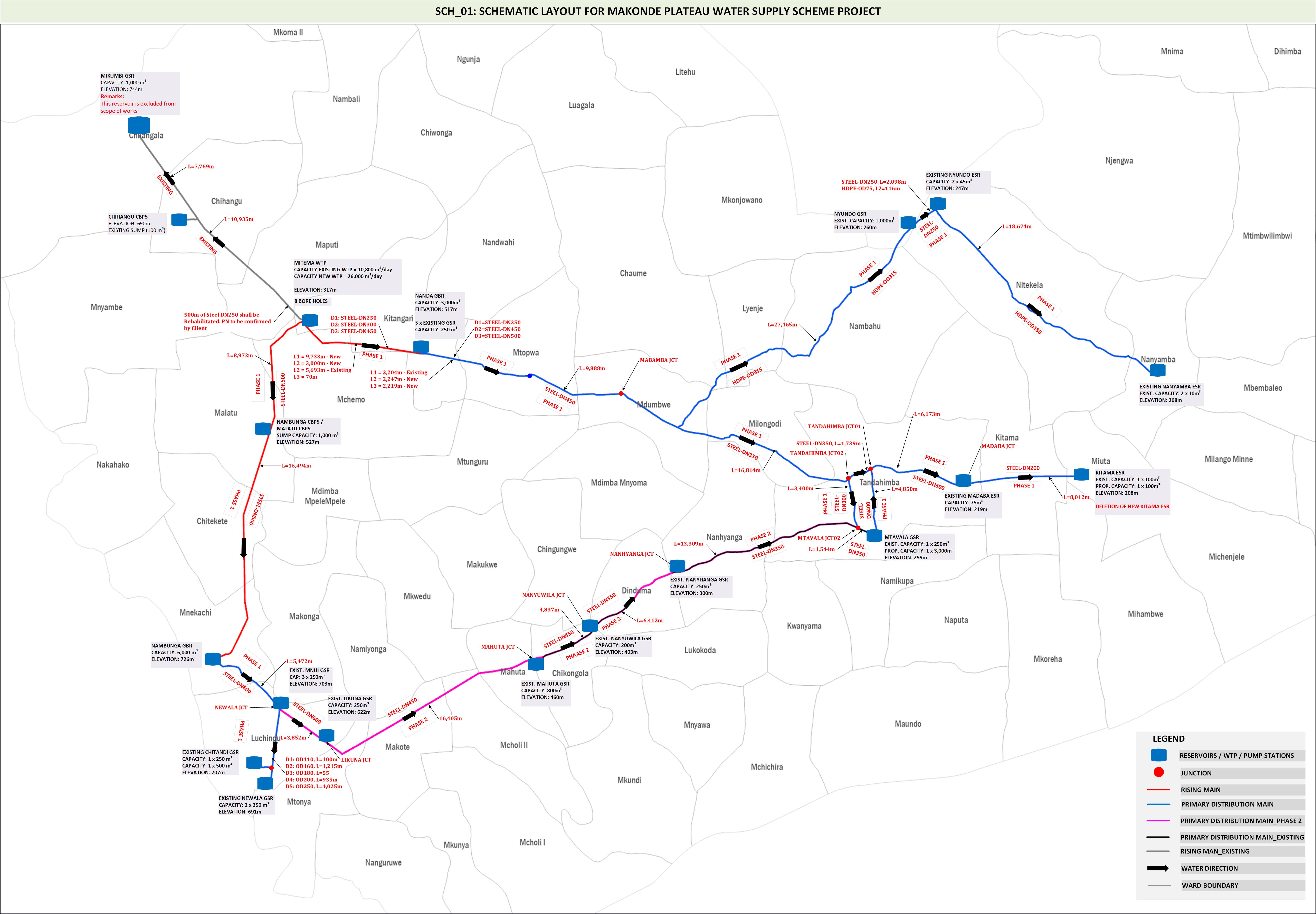
With the attached .JPEG Map, is it possible to do the annotation part in ArcGis Pro only?
I usually prepare the map for my water pipelines network, doing the symbology in ArcGis Pro, but I have to look for a third party software (MS Visio) to do the pipelines annotations. Is there a way to do all these in Arc Gis Pro?
I would appreciate if I have a sample for the same.
- Mark as New
- Bookmark
- Subscribe
- Mute
- Subscribe to RSS Feed
- Permalink
- Report Inappropriate Content
Hello!
Yes, it is possible to create annotations in ArcGIS Pro. You can choose to either create labels on your features first, then convert the labels to an annotation layer or you can create a blank annotation layer and use a label expression or SQL query to define the annotation class. Check out these two resources:
Also, you may want to consider posting this question in the ArcGIS Pro Esri Community for additional visibility.
- Mark as New
- Bookmark
- Subscribe
- Mute
- Subscribe to RSS Feed
- Permalink
- Report Inappropriate Content
Yes, it is entirely feasible to handle both symbology and annotation for your water pipelines network within ArcGIS Pro, eliminating the need for third-party software like MS Visio. Initially, you would utilize ArcGIS Pro's labeling features to add automatic labels to your pipeline features based on attribute data. These labels can then be customized for clarity and readability. For more control and customization, you can convert these labels into annotations, allowing for individual editing, such as repositioning, altering text properties, or adding graphic elements. This conversion is done through the "Convert Labels to Annotation" feature found under the Map tab. ArcGIS Pro also supports advanced annotation editing, including adding leader lines or changing background symbols for enhanced map clarity.