- Home
- :
- All Communities
- :
- Products
- :
- ArcGIS Pro
- :
- ArcGIS Pro Questions
- :
- Issues drawing/editing polygons
- Subscribe to RSS Feed
- Mark Topic as New
- Mark Topic as Read
- Float this Topic for Current User
- Bookmark
- Subscribe
- Mute
- Printer Friendly Page
Issues drawing/editing polygons
- Mark as New
- Bookmark
- Subscribe
- Mute
- Subscribe to RSS Feed
- Permalink
- Report Inappropriate Content
Hello mapping community,
I've done this type of editing in ArcPro for a while but this is a new issue I’ve encountered recently:
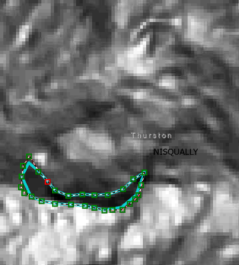
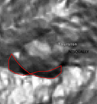
When digitizing a polygon, the vertices automatically snap together when they are nearby. The drawn polygon on the left became the polygon on the right when I finished the sketch. I tried this with snapping on, snapping off and various snapping tolerances. All produced the same result.
I checked the coordinate system for my map and the feature class are in the same projection.
Are there settings that would be causing my polygons to behave this way?
Thanks,
Emilie
- Mark as New
- Bookmark
- Subscribe
- Mute
- Subscribe to RSS Feed
- Permalink
- Report Inappropriate Content
In the Editor Settings environment, what is your snapping XY tolerance? By default, mine is 10 pixels. Related, when the feature class was created, what is the XY tolerance of that? By default, ArcGIS Pro will be 0.001 meters?
Maybe related, maybe not but you can do a soft reset of ArcGIS Pro settings by renaming the ESRI folder in your C:\users\<username>\appdata\local and C:\users\<username>\appdata\roaming to ESRI_OLD. Then restart ArcGIS Pro, load the project file and attempt the digitizing for your polygon again.
- Mark as New
- Bookmark
- Subscribe
- Mute
- Subscribe to RSS Feed
- Permalink
- Report Inappropriate Content
I have my snapping set to the default 10 pixels, though I've tried toying with different tolerances to no avail. When I check the properties of the feature class, its XY tolerance says "2 US Survey Feet" (0.6 meters). The distance between the vertices that are snapping together is 4 feet.
I'll give that soft reset a try! Thank you.
- Mark as New
- Bookmark
- Subscribe
- Mute
- Subscribe to RSS Feed
- Permalink
- Report Inappropriate Content
Interesting. So I think your 2 US Survey Feet is the problem. This, generally speaking, should not be set higher than the initial settings else "bad things happen." I'd create a new feature class with default settings and test the digitzing again. I'm thinking vertices are collapsing on one another due to the high XY Tolerance.
- Mark as New
- Bookmark
- Subscribe
- Mute
- Subscribe to RSS Feed
- Permalink
- Report Inappropriate Content
It looks like you are using the Streaming construction tool. Is that correct? It looks like this on the toolbar:
If so, check the tolerance values for that tool by right clicking on the map (while the tool is active) > choose Streaming Options:
... and change the tolerance to a value that makes sense for your data:
- Mark as New
- Bookmark
- Subscribe
- Mute
- Subscribe to RSS Feed
- Permalink
- Report Inappropriate Content
I've not been using streaming construction, just adding vertices by clicking along, but thank you for the reply.


