- Home
- :
- All Communities
- :
- Products
- :
- ArcGIS Online
- :
- ArcGIS Online Questions
- :
- Population within a 45-minute driving radius of th...
- Subscribe to RSS Feed
- Mark Topic as New
- Mark Topic as Read
- Float this Topic for Current User
- Bookmark
- Subscribe
- Mute
- Printer Friendly Page
Population within a 45-minute driving radius of the city
- Mark as New
- Bookmark
- Subscribe
- Mute
- Subscribe to RSS Feed
- Permalink
I want to find out the population figures within a 45-minute drive radius of a city. So I want to know how many people live, for example, within a 45-minute drive from Berlin.
However, I can find an analysis function that allows me to do this. I have created a travel time area, but I cannot find a way to combine this information with the population figures.
Does anyone have any ideas?
Solved! Go to Solution.
Accepted Solutions
- Mark as New
- Bookmark
- Subscribe
- Mute
- Subscribe to RSS Feed
- Permalink
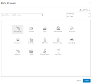
Hi @Finn, here's a solution I found. First, I created a 45 minute drive-time for Berlin. Next, I used the 'Enrich Layer' tool in the Map Viewer, selected 'Germany' and 'Population':
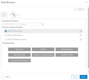
Then, I selected '2022 Total Population' and ran the tool.
This tool will create a new layer with the estimated population as an attribute:
You'd be able to achieve something similar for any area, using country specific population data, or the global population data.
Hope this helps!
James
Programme & Service Delivery @ Esri UK
- Mark as New
- Bookmark
- Subscribe
- Mute
- Subscribe to RSS Feed
- Permalink
Hi James,
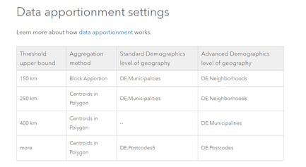
thank you very much for your instructions. This is exactly what I was looking for. This function is great. Maybe you can answer my question as to whether the population figures of the federal states or NUTS3 level are simply applied proportionately to the 45-minute area or whether it is only applied to the communities and cities that are actually located in the area.
In your picture, Potsdam, for example, is just about in the area. This leads to the question of whether the population figures are taken proportionately from the whole of Brandenburg, or whether the actual people in the area are taken into account.
Big thanks first of all.
- Mark as New
- Bookmark
- Subscribe
- Mute
- Subscribe to RSS Feed
- Permalink
Hi @Finn,
I'm hoping this documentation answers your follow up question: Germany—Esri Demographics Regional Data | Documentation (arcgis.com)
Some more information on Data Apportionment: https://developers.arcgis.com/rest/geoenrichment/api-reference/data-apportionment.htm
Programme & Service Delivery @ Esri UK
- Mark as New
- Bookmark
- Subscribe
- Mute
- Subscribe to RSS Feed
- Permalink
Thank you James! This is the information I needed. Have a good weekend.
- Mark as New
- Bookmark
- Subscribe
- Mute
- Subscribe to RSS Feed
- Permalink
@Finn for future reference, you can actually also create the drive-time radius from within the Enrich Layer tool itself, as long as your input features are points.
If you wanted the result to still be your initial point feature, just with the extra enrichment data, you would leave the 'Return output as bounding areas' parameter unchecked. If you wanted the result to be the drive-time polygon, you would check the box for 'Return output as bounding areas'.
Cheers,
Product Engineer - Web Analysis


