- Home
- :
- All Communities
- :
- Products
- :
- ArcGIS Online
- :
- ArcGIS Online Questions
- :
- Can I add another map layer as a layer in my map?
- Subscribe to RSS Feed
- Mark Topic as New
- Mark Topic as Read
- Float this Topic for Current User
- Bookmark
- Subscribe
- Mute
- Printer Friendly Page
Can I add another map layer as a layer in my map?
- Mark as New
- Bookmark
- Subscribe
- Mute
- Subscribe to RSS Feed
- Permalink
- Report Inappropriate Content
Can I add content as a layer from another map as a layer in a map I am creating? If so, how?
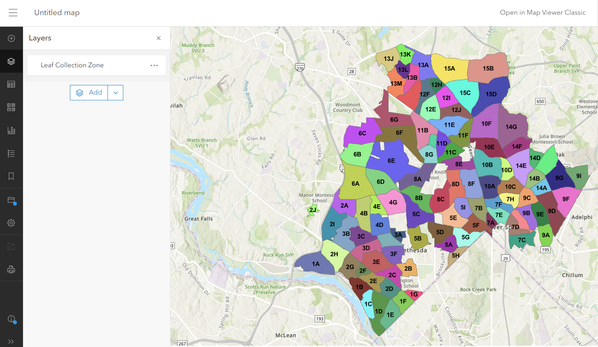
I would like to add this Leaf Collection Zones in Montgomery County, Maryland USA https://www7.montgomerycountymd.gov/arcgis/rest/services/DOT/leaf_collection/MapServer content to a map I am building.
The Montgomery County map they have in: ArcGIS JavaScript, ArcGIS Online Map Viewer ,ArcGIS Earth ArcMap ,ArcGIS Pro, and View Footprint In: ArcGIS Online Map Viewer
But if try to Add Layer from the Web it does not work.
Solved! Go to Solution.
Accepted Solutions
- Mark as New
- Bookmark
- Subscribe
- Mute
- Subscribe to RSS Feed
- Permalink
- Report Inappropriate Content
Hi Mark,
You can definitely add the leaf layer to a map.
Click on that link in your post and then scroll down to:
And Click on "Leaf Collection Zone".
That will take you a new page. Copy the Url which is this:
https://www7.montgomerycountymd.gov/arcgis/rest/services/DOT/leaf_collection/MapServer/0
Now open a new or existing map and go to layers and add a new layer from an Url and paste that into the spot, et Voila!
BAM!!!
Please let us know you got this far.
Do any of the community members know an easier way to do this from the REST Services?
Can one edit this layer?
What is all this REST Services about anyway, Earl?
RSVP - Thanks!
- Mark as New
- Bookmark
- Subscribe
- Mute
- Subscribe to RSS Feed
- Permalink
- Report Inappropriate Content
Greetings @MarkDoehnert
As @RonaldHaug suggests, you can add it as a Feature layer from the map service by using the "0" index the REST endpoint. If you are planning to use the Feature layer in other maps, you can add it to your Content by clicking + New item > URL, and then providing the URL https://www7.montgomerycountymd.gov/arcgis/rest/services/DOT/leaf_collection/MapServer/0
You should then be able to add it to any existing or new maps.
To learn more about the REST endpoint (every ArcGIS Server has one) please see Using the Services Directory
If you want to learn more about what other services and layers are publicly available from the Montgomery County services directory, check https://www7.montgomerycountymd.gov/arcgis/rest/services In the page you will see "Current version: 10.91" This indicates that the hosting ArcGIS Server is at version 10.9.1.
Hope the above information is of assistance.
- Mark as New
- Bookmark
- Subscribe
- Mute
- Subscribe to RSS Feed
- Permalink
- Report Inappropriate Content
Hi Mark,
You can definitely add the leaf layer to a map.
Click on that link in your post and then scroll down to:
And Click on "Leaf Collection Zone".
That will take you a new page. Copy the Url which is this:
https://www7.montgomerycountymd.gov/arcgis/rest/services/DOT/leaf_collection/MapServer/0
Now open a new or existing map and go to layers and add a new layer from an Url and paste that into the spot, et Voila!
BAM!!!
Please let us know you got this far.
Do any of the community members know an easier way to do this from the REST Services?
Can one edit this layer?
What is all this REST Services about anyway, Earl?
RSVP - Thanks!
- Mark as New
- Bookmark
- Subscribe
- Mute
- Subscribe to RSS Feed
- Permalink
- Report Inappropriate Content
Thank you Ronald - I had no idea the content of that entire page was the layer! So I had no idea that was the URL to copy - it worked perfectly!!
- Mark as New
- Bookmark
- Subscribe
- Mute
- Subscribe to RSS Feed
- Permalink
- Report Inappropriate Content
Greetings @MarkDoehnert
As @RonaldHaug suggests, you can add it as a Feature layer from the map service by using the "0" index the REST endpoint. If you are planning to use the Feature layer in other maps, you can add it to your Content by clicking + New item > URL, and then providing the URL https://www7.montgomerycountymd.gov/arcgis/rest/services/DOT/leaf_collection/MapServer/0
You should then be able to add it to any existing or new maps.
To learn more about the REST endpoint (every ArcGIS Server has one) please see Using the Services Directory
If you want to learn more about what other services and layers are publicly available from the Montgomery County services directory, check https://www7.montgomerycountymd.gov/arcgis/rest/services In the page you will see "Current version: 10.91" This indicates that the hosting ArcGIS Server is at version 10.9.1.
Hope the above information is of assistance.


