- Home
- :
- All Communities
- :
- Developers
- :
- ArcGIS Online Developers
- :
- ArcGIS Online Developers Questions
- :
- Arcade intersection
- Subscribe to RSS Feed
- Mark Topic as New
- Mark Topic as Read
- Float this Topic for Current User
- Bookmark
- Subscribe
- Mute
- Printer Friendly Page
- Mark as New
- Bookmark
- Subscribe
- Mute
- Subscribe to RSS Feed
- Permalink
- Report Inappropriate Content
I would like to know if it is possible to use the intersection function on a polygon and line. An example would be to create a new geometry based on the road centerlines that fall within an urbanized boundary. I have not come across any examples and everything I try, does not work.
Solved! Go to Solution.
Accepted Solutions
- Mark as New
- Bookmark
- Subscribe
- Mute
- Subscribe to RSS Feed
- Permalink
- Report Inappropriate Content
You can use this expression as Attribute Rule (triggers on Insert & Update) or in a popup:
// load the line fc
var lines = FeaturesetByName($datastore, "TestLines")
// get all intersecting lines
var i_lines = Intersects($feature, lines)
// for each intersecting line, get the length of the intersection, accumulate
var total = 0
for(var line in i_lines) {
    total += Length(Intersection(line, $feature))
}
return total
Have a great day!
Johannes
- Mark as New
- Bookmark
- Subscribe
- Mute
- Subscribe to RSS Feed
- Permalink
- Report Inappropriate Content
Can you share what you've tried? And what it is you're trying to accomplish? Intersecting features like you describe is absolutely possible in Arcade, but bringing those intersected features back to a map to actually visualize them (what I assume you mean by "create a new geometry") is not.
Kendall County GIS
- Mark as New
- Bookmark
- Subscribe
- Mute
- Subscribe to RSS Feed
- Permalink
- Report Inappropriate Content
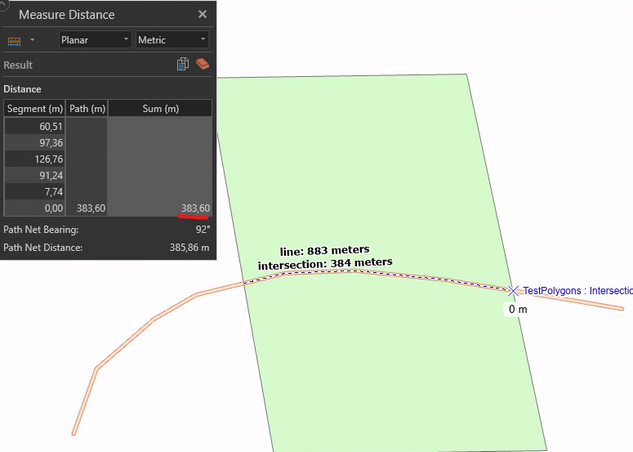
Take a look at Intersection().
For example:
Calculate a field in the line feature class:
var polygons = FeaturesetByName($datastore, "TestPolygons")
var polygon = First(Intersects(polygons, $feature))
if(polygon == null) { return null }
var i_line = Intersection(polygon, $feature)
return Length(i_line)
Label the line with this expression
`line: ${Round(Length($feature))} meters\nintersection: ${Round($feature.DoubleField)} meters`
Result:
Have a great day!
Johannes
- Mark as New
- Bookmark
- Subscribe
- Mute
- Subscribe to RSS Feed
- Permalink
- Report Inappropriate Content
Thanks for the help. Ultimately, what I am looking for is to be able to modify the boundary shape (urbanized area poly) and return the sum of each of the functionally classified road lengths.
- Mark as New
- Bookmark
- Subscribe
- Mute
- Subscribe to RSS Feed
- Permalink
- Report Inappropriate Content
Is this a field calculation? A popup? An attribute rule?
Kendall County GIS
- Mark as New
- Bookmark
- Subscribe
- Mute
- Subscribe to RSS Feed
- Permalink
- Report Inappropriate Content
Thanks so much! What I am trying to do, is to create a popup for the box and have it populate the total length of the lines that run through the box.
- Mark as New
- Bookmark
- Subscribe
- Mute
- Subscribe to RSS Feed
- Permalink
- Report Inappropriate Content
You can use this expression as Attribute Rule (triggers on Insert & Update) or in a popup:
// load the line fc
var lines = FeaturesetByName($datastore, "TestLines")
// get all intersecting lines
var i_lines = Intersects($feature, lines)
// for each intersecting line, get the length of the intersection, accumulate
var total = 0
for(var line in i_lines) {
    total += Length(Intersection(line, $feature))
}
return total
Have a great day!
Johannes
- Mark as New
- Bookmark
- Subscribe
- Mute
- Subscribe to RSS Feed
- Permalink
- Report Inappropriate Content
Depending on the length of your lines, you might want to use LengthGeodetic() instead of Length() to account for Earth's curvature.
Have a great day!
Johannes
- Mark as New
- Bookmark
- Subscribe
- Mute
- Subscribe to RSS Feed
- Permalink
- Report Inappropriate Content
Thank You Johannes!


