Note: This is not actually a question, I am trying to somehow report this issue to Esri but the options available for bug reports don't feel like they're well-suited to this case
When creating a 2-vertex Polyline from an Array of PointGeometry objects (via InsertCursor), the line is forcibly created with 0-length (null) geometry if the distance between the two points is < 0.0002 in units of the target layer's spatial reference. This means that, without a projected coordinate system, lines < 53.5 FEET long cannot be created!
arcpy should absolutely assume that any variation between coordinates is real and should create a line based on the supplied coordinates. It should not assume something is zero-length based on a rounded or calculated length... and currently it's making that assumption from the rounding of a calculated length! It is possible to manually create a line that measures with a Shape_Length < 0.000001 degrees -- so it should be just as possible to create that line (and any other) with Python
Evidence of this cutoff: Result of creating lines in unprojected WGS84 from two-point arrays, where the first point is at [-70.0, 43.0] and the second is at [Latitude, 43.0]
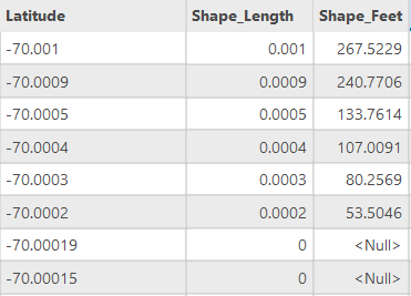
In conclusion: If you are using arcpy to create polylines and they are unexpectedly returning null geometries, try calculating the length between coordinates. If it's teeny-tiny, you have to use a different coordinate system to make it to work!
(I discovered this problem because a coworker was getting null geometry from a custom tool we use frequently when running it based on AGOL data that's in WGS84. I fixed it by telling the tool to use that map's spatial reference if the source layer's SC is geographic. I think this sounds like kind of a niche issue, but I can think of numerous ways that it could continue to hassle us down the line if I hadn't identified the reason & solution)


