- Home
- :
- All Communities
- :
- Products
- :
- Imagery and Remote Sensing
- :
- Imagery Questions
- :
- Re: Can you clip a MrSID file in arcmap?
- Subscribe to RSS Feed
- Mark Topic as New
- Mark Topic as Read
- Float this Topic for Current User
- Bookmark
- Subscribe
- Mute
- Printer Friendly Page
- Mark as New
- Bookmark
- Subscribe
- Mute
- Subscribe to RSS Feed
- Permalink
- Report Inappropriate Content
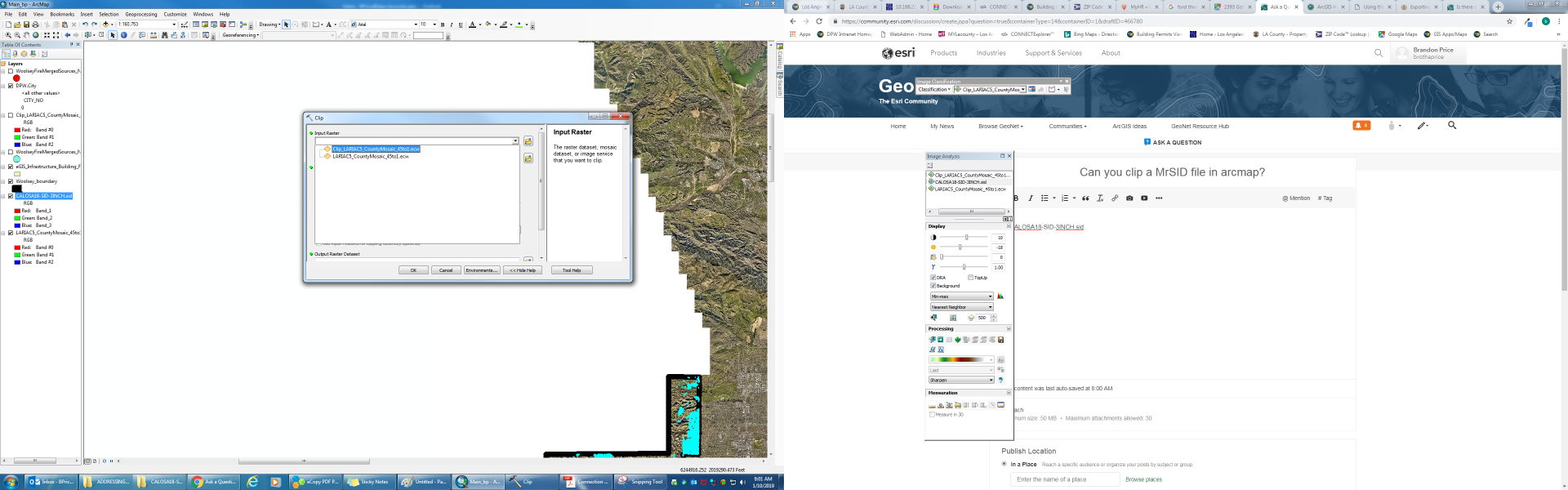
I am tried to clip the MrSid image highlighted in the table of contents using the export data option and the clip (data management) tool and neither work. The export data option is not there when you right click on the sid layer in the table of contents and the sid layer does not even show up in the clip tool as a potential layer to clip. Can someone please advise? Thanks.
Solved! Go to Solution.
Accepted Solutions
- Mark as New
- Bookmark
- Subscribe
- Mute
- Subscribe to RSS Feed
- Permalink
- Report Inappropriate Content
Brandon
I don't understand why this isn't working. It works on my computer, although I do see in your screenshot that the *sid file is not offered as an available input.
the Help doc here Clip—Help | ArcGIS Desktop confirms it shouldn't be a licensing problem (I have ArcMap Advanced, thought you might have Basic) so it should work.
Note instead of running the GP tool, you can do a clip using the Image Analysis window (IAW).
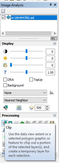
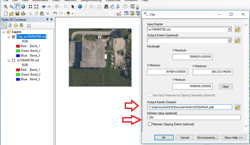
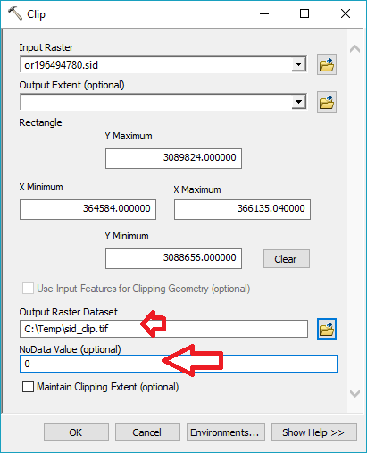
Note that the clipped image from IAW is virtual, on screen only, so then you'd need to Export (right click in table of contents) and Save As, noting that you can't write out *.sid files in ArcMap, so you'd have to save a TIFF or other format. (By default it tries to write a raster into a database, so you may want to change this to a file path and then end filename with *.tif).
Also, in the Export step it may try to promote your data to 16 bit and set NoData value to 256, so I assume you'd want to set this value to 0.
defaults shown:
change these fields:
- Mark as New
- Bookmark
- Subscribe
- Mute
- Subscribe to RSS Feed
- Permalink
- Report Inappropriate Content
You may need to export/copy the MrSID to a different format then clip the raster. This could be done via a model or Python.
MrSID is a "read-only" within ArcGIS:
List of supported raster and image data formats—Help | ArcGIS Desktop
Supported raster dataset file formats—Help | ArcGIS Desktop
- Mark as New
- Bookmark
- Subscribe
- Mute
- Subscribe to RSS Feed
- Permalink
- Report Inappropriate Content
Thanks George. I am using the copy raster in arccatalog suggested from your other thread: https://community.esri.com/message/379970?commentID=379970#comment-379970 . I get errors:
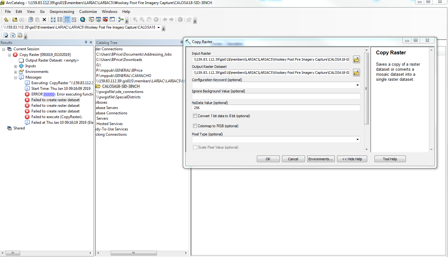
Any advice?
- Mark as New
- Bookmark
- Subscribe
- Mute
- Subscribe to RSS Feed
- Permalink
- Report Inappropriate Content
Your destination folder is quite long and unwieldy and contains spaces in the path etc.
Try a local simple folder to get the process working
And! make sure you specify a file extension. *.tif files are the recommended raster format, so
C:/test/test.tif
would be a good candidate name for the export.
If you don't specify an appropriate file extension, your paths will cause esri grid formats to fail.
- Mark as New
- Bookmark
- Subscribe
- Mute
- Subscribe to RSS Feed
- Permalink
- Report Inappropriate Content
so far so good. still processing.
- Mark as New
- Bookmark
- Subscribe
- Mute
- Subscribe to RSS Feed
- Permalink
- Report Inappropriate Content
Brandon
I don't understand why this isn't working. It works on my computer, although I do see in your screenshot that the *sid file is not offered as an available input.
the Help doc here Clip—Help | ArcGIS Desktop confirms it shouldn't be a licensing problem (I have ArcMap Advanced, thought you might have Basic) so it should work.
Note instead of running the GP tool, you can do a clip using the Image Analysis window (IAW).
Note that the clipped image from IAW is virtual, on screen only, so then you'd need to Export (right click in table of contents) and Save As, noting that you can't write out *.sid files in ArcMap, so you'd have to save a TIFF or other format. (By default it tries to write a raster into a database, so you may want to change this to a file path and then end filename with *.tif).
Also, in the Export step it may try to promote your data to 16 bit and set NoData value to 256, so I assume you'd want to set this value to 0.
defaults shown:
change these fields:
- Mark as New
- Bookmark
- Subscribe
- Mute
- Subscribe to RSS Feed
- Permalink
- Report Inappropriate Content
ultiresolution Seamless Image Database (MrSID) | A proprietary compression technique especially for maintaining the quality of large images. Allows for a high compression ratio and fast access to large amounts of data at any scale. The MrSID Encoder is developed and supported by LizardTech, Inc. Supports generations 2, 3, and 4. | Single file—extension *.sid World file—extension *.sdw | Read-only | 8- and 16-bit unsigned integer | Yes Generation 2 and generation 3—limited to 1 or 3 bands Generation 4—unlimited |

Read only.. isn't correct then
So Raster file formats—ArcGIS Pro | ArcGIS Desktop
the above is only partially correct or is there more offered if you have the Data Interoperability extension?
- Mark as New
- Bookmark
- Subscribe
- Mute
- Subscribe to RSS Feed
- Permalink
- Report Inappropriate Content
I will definitely try this method Monday if the copyraster never completed because I left the process to run over the weekend. This makes sense that it would be much faster. I will keep this in mind for the future. Thanks Cody.
- Mark as New
- Bookmark
- Subscribe
- Mute
- Subscribe to RSS Feed
- Permalink
- Report Inappropriate Content
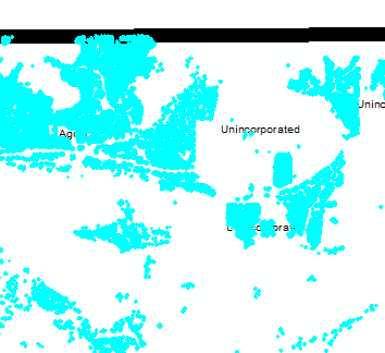
I still cannot save to another format by doing a right click sand save as for the sid file in the table of contents. I also do not know how to specify how to clip the image using selected polygons in the image analysis window. View screen:
- Mark as New
- Bookmark
- Subscribe
- Mute
- Subscribe to RSS Feed
- Permalink
- Report Inappropriate Content
Brandon
Help is here Using the Clip button on the Image Analysis window—Help | ArcGIS Desktop and I showed the UI's above for clipping. What happens when you try that? Error? Nothing?
as for saving, Right click in table of contents (select the new layer after clip) to Export / Save As should also work to save a *.tif image copy of the *.sid image. Help is here Exporting a raster in ArcMap—Help | ArcGIS Desktop
If these are not working, please log a support incident with Technical Support
https://support.esri.com/en/contact-tech-support
It looks like you have 1,000 polygons. Are you intending to clip out 1,000 separate tiny image in separate files? Or are you expecting to create one single image with 1,000 "islands" but remove all the pixels in between?
Clipping from the Image Analysis Window (IAW) will do the latter; if you want the former, you'd have to use a GP tool or Python to select and clip one at a time, but I have a feeling there must be a better way to reach your end goal. If you put your *.sid file into a mosaic dataset and use your polygons to define the Footprint, then set mosaic dataset properties to "Clip to footprint? = Yes" you'll get 1,000 islands with no pixels in between. If your subsequent processes are in ArcMap this should work, but if you're trying to export to some other software, it won't understand the mosaic dataset. Can you let us know what you're seeking to accomplish?
Cody