- Home
- :
- All Communities
- :
- User Groups
- :
- Conservation GIS
- :
- Documents
- :
- 2000 Scgis 3d Annual Conference, La Casa Del Zorro...
- Subscribe to RSS Feed
- Mark as New
- Mark as Read
- Bookmark
- Subscribe
- Printer Friendly Page
2000 Scgis 3d Annual Conference, La Casa Del Zorro, Borrego Springs
2000 Scgis 3d Annual Conference, La Casa Del Zorro, Borrego Springs
2000 Scgis Third Annual Conference xHistory xConference xScgis x2000
SCGIS 2000 Conference, June 24-25, 2000
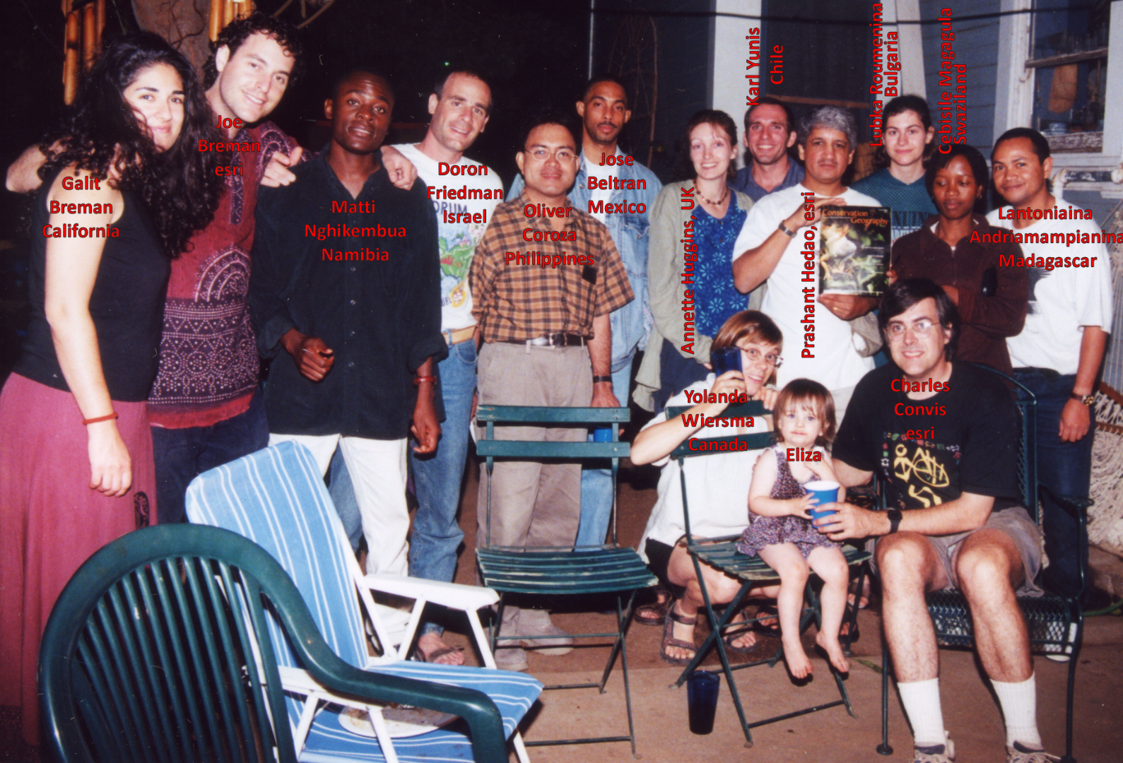
PHOTO ABOVE: SCGIS SCHOLARS, Year 2000 REDLANDS, CA
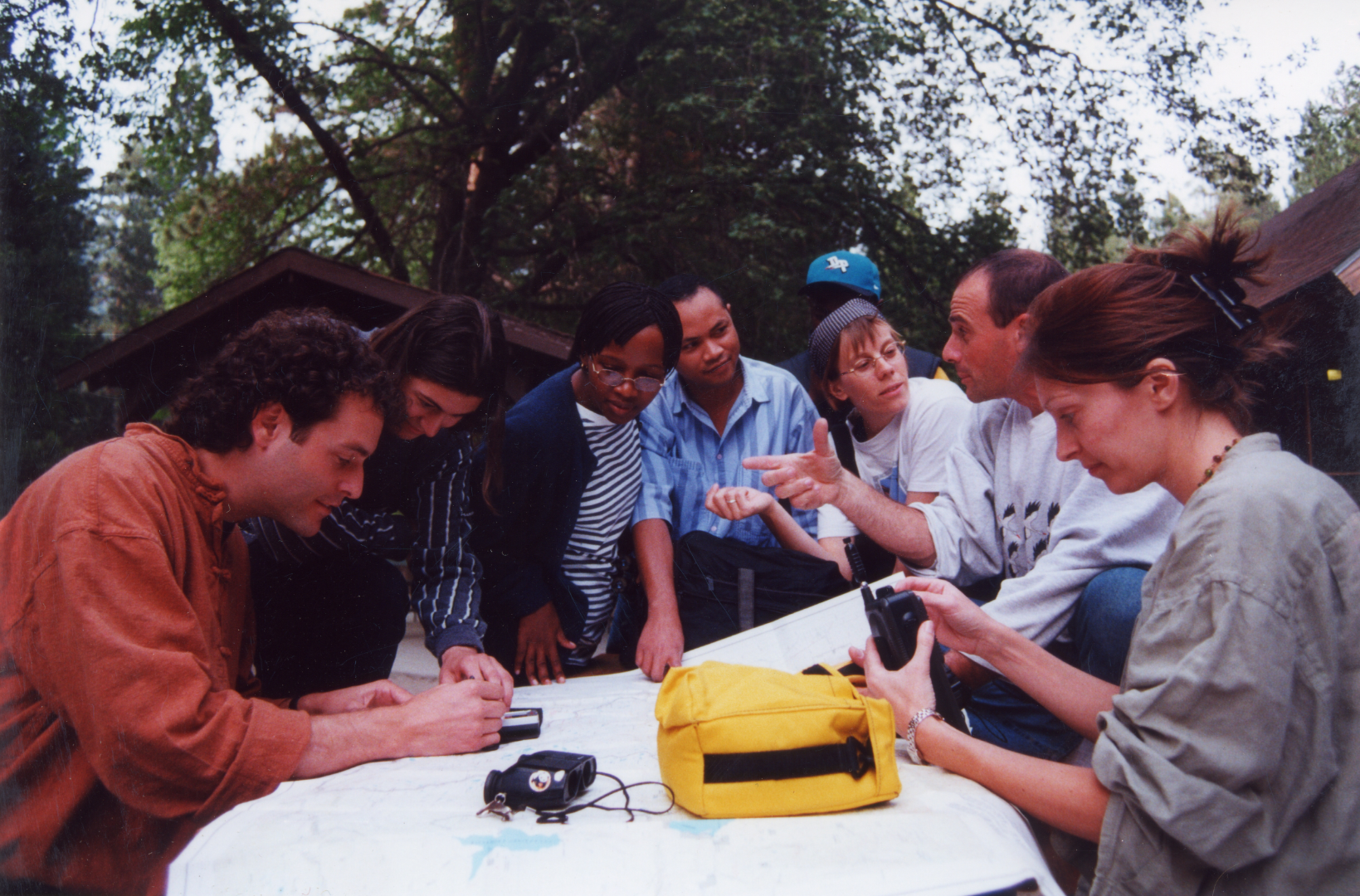
PHOTO ABOVE: SCGIS SCHOLARS, Year 2000, at James Reserve Field GPS Class. L-R Joe Breman, Lubka Roumenina, Cebisile Magaula, Lanto Andriamampianina, Yolanda Wiersma, Doron Friedman, Annette Huggins.
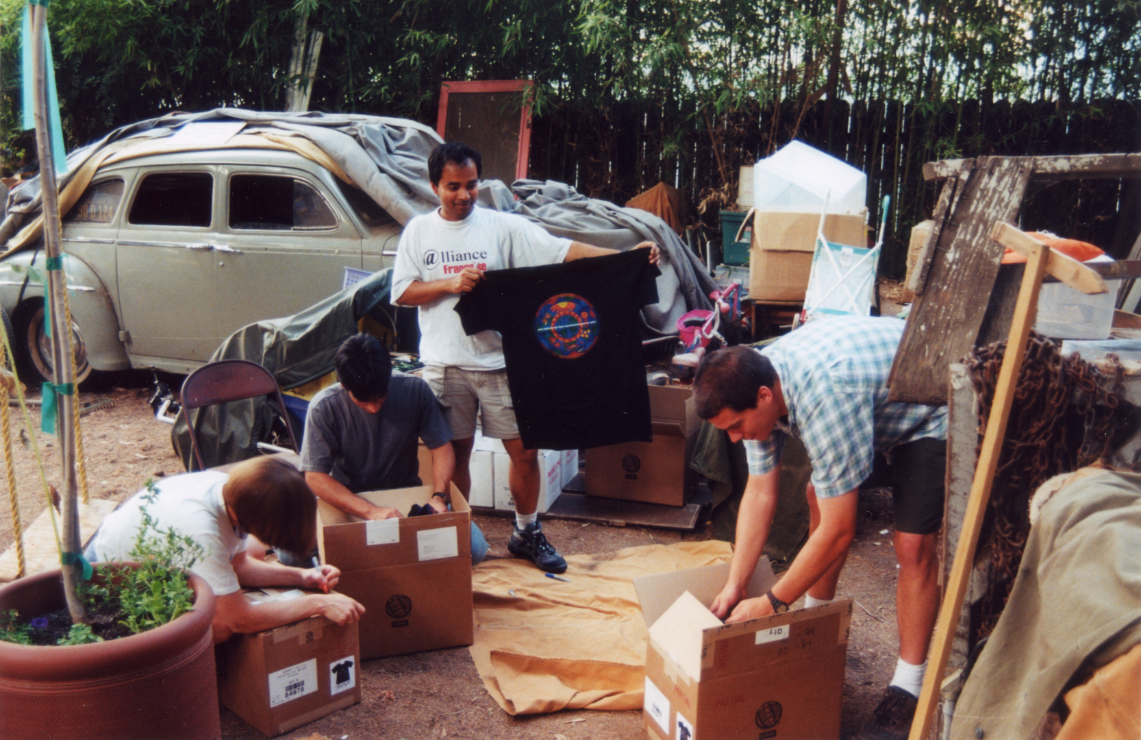
PHOTO ABOVE: SCGIS 2000 Volunteers help get SCGIS T-shirts ready to sell. The 1941 Desoto in the background had a sign saying "SCGIS International Headquarters" for over a decade, as it served as the clubhouse & storeroom for Scgis shirts, posters and conference support equipment.
Scheduled Speakers as of April 20, 2000 (I) denotes SCGIS international scholarship recipient
Track: Data Access and Development
Allen Carroll, acarroll@ngs.org, "EarthMap: an Initiative of ESRI and the National Geographic Society"
Bill Eichenlaub, bill_eichenlaub@nps.gov, ' Building "Oh Wow!" GIS Databases in Microsoft Access'
Paul Flemons, paulf@austmus.gov.au, Mapping Biodiversity Data on the Web
Penny Flick, p.flick@conservation.org, Conservation International's Prisma: A Multimedia Database Publisher
Hugh Irwin, hugh@safc.org, Effective Tools for Finding GIS Data and Sharing Your Own
(I) Cebisile N. Magagula, Cebisile@UniswaCC.Uniswa.sz, Swaziland National Biodiversity Database Unit
Robert Norheim, norheim@u.washington.edu, How Institutional Cultures Affect Results: Comparing Two Old-Growth Forest Mapping Projects
Dave Theobald, davet@nrel.colostate.edu, When You've Got It But Can't Use It: Dealing With Sensitive Data
(I) Patricia Vera, patriciavera@usa.net, Defenders of Forest in Chile
Richard Warnick, rmwarnick@aol.com, A Digital Atlas of Utah Wilderness
Andy Weiss, adw@ntsg.umt.edu, Applications of Earth Observing System Data to Terrestrial Conservation Issues
(I) Yolanda F. Wiersma, ywiersma@uoguelph.ca, Utilizing GIS To Estimate Historical Species Distributions: Two Approaches
(I) Gregg A. Young, Gytribalepa@pacific.net, GIS And Quality Assurance Under The US EPA, Tribal GAP
Track: Regional Planning and Urban Development
(I) Ferdinand Addo , foaddo@hotmail.com, GIS as a Tool for Cultural Resource Management
(I) Lantoniaina Andriamampianina, wcsmad@dts.mg, The Madagascar Biodiversity Mapping Project
(I) Oliver Coroza, ciphil@csi.com.ph, Priority-Setting Of Biodiversity Conservation In The Philippines
Erik Franklin, erik.franklin@noaa.gov , The role of GIS in planning a marine ecological reserve in the Florida Keys, USA
Tom Hoctor, tomh@geoplan.ufl.edu, Identifying An Ecological Reserve Network in the Southeastern United States
Rich Hunter, rich@calwild.org, South Coast Wildlands Project - Vision Maps for Landscape Connectivity
Arlene Olivero, Arlene_olivero@tnc.org, GIS analysis for Ecoregional Planning and Site Selection
Laura Pinnas, laura@alumni.duke.edu, When 1+1<2: Open Space, Development and Fragmentation
(I) Lubka Roumenina, roumenina@hotmail.com, Using GIS In Some Environmental Monitoring Projects In Sofia City
(I) S. Espinosa Silvio , silvio@wwf.org.co, Conservation and Sustainable Development in Northern Andean Mountain Ecoregions
Dave Theobald, davet@nrel.colostate.edu, Using build-out scenarios to identify potential impacts to habitat
(I) Mai Ky Vinh, maikyvinh@hn.vnn.vn, Applying GIS To Expanding The Protected Areas Network In Vietnam
Track: Advanced Conservation GIS Techniques
Alvaro Espinel, a.espinel@conservation.org, CONDOR 1.1 Decision Tool
Pat Halpin & Andrew Bunn, phalpin@duke.edu, Network models of habitat connectivity: Marine and terrestrial applications
Michael Hamilton, director@jamesreserve.edu, Biocomplexity Mapping: Ubiquitous Remote Sensing for Monitoring Biodiversity in a Protected Ecosystem
Eugene Martin, eugene@commenspace.org, Watershed Impervious Surface Assessment Using Spectral Mixing Analysis
Lisa Ann Pierce, lpierce@esri.com, Conservation GIS Using Spatial Analyst Model Builder and 3D Analyst
Track: Microfauna to Megafauna
(I) Annette Huggins, aeh6@ukc.ac.uk, Assessing The Habitat Preferences Of Black Rhinoceros
Pey-Yi Lee, pylee@citrus.ucr.edu, The spatial patterns of breeding locations of San Clemente Loggerhead Shrike
Raquel Leyva, Raquel@hobbes.tcru.ttu.edu, The use of GIS to describe the effects of climatic variability on scaled quail
(I) Matti Nghikembua, cheeta@iafrica.com.na, Habitat Monitoring For The Endangered Cheetah In Namibia
Joshua Viers, josh@ice.ucdavis.edu, Biogeographic Analysis of Mountain Lion
Rebecca Young, rebecca.young@stanford.edu, Predicting lemur species distributions in the eastern rain forest region of Madagascar
Track: Professional Development
Will Allen & Paul Zwick, will@tcf.arcana.com, Journal of SCGIS Planning Meeting
Chris Davis, chris@commenspace.org, Pacific Northwest Conservation GIS User Study 1999: Implications for SCGIS
Brenda Pounds, Brenda.Pounds@ssc.nasa.gov, NASA Commercial Remote Sensing Program's Workforce Development National Implementation Plan
-
 Anonymous User