Turn on suggestions
Auto-suggest helps you quickly narrow down your search results by suggesting possible matches as you type.
Cancel
- Home
- :
- All Communities
- :
- Products
- :
- ArcGIS Network Analyst
- :
- ArcGIS Network Analyst Questions
- :
- Re: ESRI North American Streets data incomplete?
Options
- Subscribe to RSS Feed
- Mark Topic as New
- Mark Topic as Read
- Float this Topic for Current User
- Bookmark
- Subscribe
- Mute
- Printer Friendly Page
ESRI North American Streets data incomplete?
Subscribe
628
4
05-06-2013 09:43 AM
05-06-2013
09:43 AM
- Mark as New
- Bookmark
- Subscribe
- Mute
- Subscribe to RSS Feed
- Permalink
- Report Inappropriate Content
So i downloaded the ESRI NA all roads data and have selected and am working with only a few counties in my area which I wanted to create a network dataset on. The attributes it contains are great and will be perfect for my usage, but at first glance and investigation I can see some streets (in-particular main highways and interstates) that have sections missing. Some areas where it is just multiple links and the road picks up again. I have my county data with all streets that seems to have it right, but the ESRI data within is much much better. This is going to be saved onto a university database for class purposes, so I would like to make sure the connections are made. What would work best to keep the ESRI data but have the connections made: simple spatial join? Append?
4 Replies
05-06-2013
10:45 AM
- Mark as New
- Bookmark
- Subscribe
- Mute
- Subscribe to RSS Feed
- Permalink
- Report Inappropriate Content
05-06-2013
12:14 PM
- Mark as New
- Bookmark
- Subscribe
- Mute
- Subscribe to RSS Feed
- Permalink
- Report Inappropriate Content
It is an unfortunate truth that ESRI street data is lacking in completeness and accuracy.
The same will hold true for any street coverage you may acquire from most agencies.
The issue is not limited to ESRI.
For my clients is has been a long process over years. IF you can get them to give it to you
ESRI does not generate centerline data they rely on other sources to provide it. For each of my clients areas I have spent years drawing in roads based on air photos and from road construction maps.
Generally my favorite source for good center line data is from a county's E911 system.
Oftentimes ESRI's data is not great because some agencies that actually generate new and accurate data are not willing to share it.
ESRI center line data happens to match the center line data from my state DOT. and that only gets updated every few years.
So i downloaded the ESRI NA all roads data and have selected and am working with only a few counties in my area which I wanted to create a network dataset on. The attributes it contains are great and will be perfect for my usage, but at first glance and investigation I can see some streets (in-particular main highways and interstates) that have sections missing. Some areas where it is just multiple links and the road picks up again. I have my county data with all streets that seems to have it right, but the ESRI data within is much much better. This is going to be saved onto a university database for class purposes, so I would like to make sure the connections are made. What would work best to keep the ESRI data but have the connections made: simple spatial join? Append?
05-06-2013
12:39 PM
- Mark as New
- Bookmark
- Subscribe
- Mute
- Subscribe to RSS Feed
- Permalink
- Report Inappropriate Content
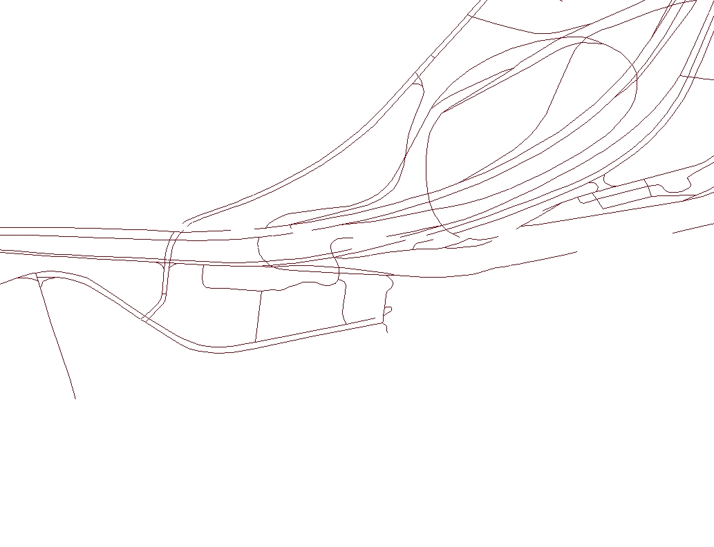
Here is an example of missing connections. An these are major highways like I said. [ATTACH=CONFIG]24075[/ATTACH]
Can you provide the spatial extent or city/street name for the posted image?
Jay Sandhu
05-06-2013
12:46 PM
- Mark as New
- Bookmark
- Subscribe
- Mute
- Subscribe to RSS Feed
- Permalink
- Report Inappropriate Content
The free street data that comes with the ArcGIS software is not the most current data available. Better and more current datasets are available for purchase in the form of StreetMap Premium products. Details here:
http://www.esri.com/data/streetmap
As far as merging two different datasets goes, that is not a simple straightforward task. The GP tool, Integrate, can help in joining data.
http://resources.arcgis.com/en/help/main/10.1/index.html#//00170000002s000000
Regards,
Jay Sandhu
http://www.esri.com/data/streetmap
As far as merging two different datasets goes, that is not a simple straightforward task. The GP tool, Integrate, can help in joining data.
http://resources.arcgis.com/en/help/main/10.1/index.html#//00170000002s000000
Regards,
Jay Sandhu