Turn on suggestions
Auto-suggest helps you quickly narrow down your search results by suggesting possible matches as you type.
Cancel
- Home
- :
- All Communities
- :
- Products
- :
- ArcGIS CityEngine
- :
- ArcGIS CityEngine Questions
- :
- Matt's Youtube Channel
Options
- Subscribe to RSS Feed
- Mark Topic as New
- Mark Topic as Read
- Float this Topic for Current User
- Bookmark
- Subscribe
- Mute
- Printer Friendly Page
Matt's Youtube Channel
Subscribe
462
3
04-29-2013 12:09 AM
04-29-2013
12:09 AM
- Mark as New
- Bookmark
- Subscribe
- Mute
- Subscribe to RSS Feed
- Permalink
- Report Inappropriate Content
http://www.youtube.com/channel/UCNS4TLgToEDQiH9pi06ofOA
Let me know what videos you'd like to see.
I'll try to make time for the most important ones !
😮
Matt
Let me know what videos you'd like to see.
I'll try to make time for the most important ones !
😮
Matt
3 Replies
09-05-2013
04:33 AM
- Mark as New
- Bookmark
- Subscribe
- Mute
- Subscribe to RSS Feed
- Permalink
- Report Inappropriate Content
Hello, Matt!
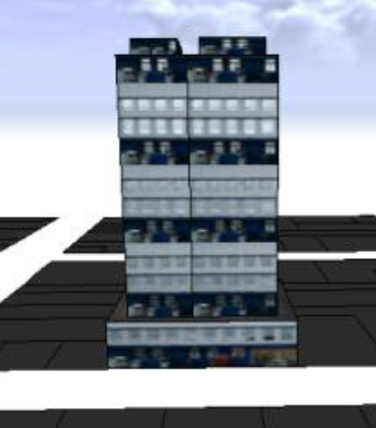
I would like to see a video to create a rule to build a model like this:
Front setback in the first floor = 5.9 meters
No setbacks in the next 10 meters
after this, back setback = 5 meters and side setback = 1.5 meters.
Is that possible?;):D:o:rolleyes:
[ATTACH=CONFIG]27229[/ATTACH]
[ATTACH=CONFIG]27230[/ATTACH]
[ATTACH=CONFIG]27231[/ATTACH]
12-01-2013
03:52 PM
- Mark as New
- Bookmark
- Subscribe
- Mute
- Subscribe to RSS Feed
- Permalink
- Report Inappropriate Content
Hi Matt,
I would like to see video of how to apply terrain to cityengine residential neighbourhood models. For example, using data of Honolulu on the side of the hill. It would be helpful to start from various terrain sources such as LIDAR, and possibly google earth.
Is there a script or ... to simplify having house, condos, etc. models grounded rather than floating?
12-09-2013
03:00 AM
- Mark as New
- Bookmark
- Subscribe
- Mute
- Subscribe to RSS Feed
- Permalink
- Report Inappropriate Content
I'm not sure if I can follow perfectly.
In a 'typical' CityEngine project, the user starts with the terrain, then aligns the shapes to the terrain.
Where the elevation data originally comes from does not matter, as long as it's imported into CityEngine as a raster image. Means CityEngine currently only supports 'heightmaps' as terrains, no TINs or LIDAR or Esri Grids.
[ I've created most rules for the Honolulu dataset, so I know the project quite well. ]
Let me know if there's more questions !
Matt