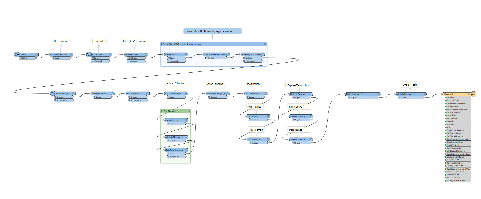
もしあなたのチームの仕事が繰り返しのカスタムデータ取り込み <\/STRONG>を必要とするなら、ワンステッププロセス - いわゆるイージーボタン<\/STRONG>にすることに興味があるでしょう。<\/P>最良の<\/EM>ETL統合の共有方法は、宛先データセットをフィーチャ サービスにすることです。これは共有に理想的であり、もちろんEnterpriseでウェブツールを作成できます。 しかし、時にはこれらのオプションを使えない場合があります。あなたや同僚、または組織外や知らない人々のような志を同じくする人たちのためだけにデータセットを簡単に取り込みたい場合です。 同じ仕事をしている誰もが同じ方法でデータを作成したいだけです<\/STRONG>。 あなたのデータは機密性が高いか時間制限があるかもしれませんし、ネットワークから離れているかもしれません。 データをジオデータベースに一度でロードしたいだけです<\/STRONG>。<\/P>Esriの数チームが最近この問題で私のところに来ましたが、両方の場合とも解決策は同じでした - ArcGIS Data Interoperability<\/STRONG> カスタムフォーマット<\/STRONG><\/A>です。 Data Interoperabilityには「イージーボタン」と呼ばれるQuick Import<\/STRONG><\/A>ジオプロセシングツールがあります。 このツールでは約500種類の非ラスター形式から任意のものを選択し、ファイルジオデータベースに変換できます。 新しいフォーマットを追加するには<\/STRONG>、それらを作成するだけでいいのです!安心してください、これはノーコード体験<\/STRONG>です。 その後、それらを誰とでも共有できます。 私の同僚の場合は、XMLやCSVの特別な「方言」を扱っており、正しくフィーチャを作成するために特定のロジックが必要でした。 カスタムフォーマットは既存フォーマット(例:XML、CSVなど数百種類)の上に構築されており<\/STRONG>、必要に応じてフィーチャクラスやテーブルを作成するすべてのロジックをカプセル化しています<\/STRONG>。<\/P>現在の米国天気情報は場所で問い合わせ可能です:<\/A><\/P>国立気象局レポート<\/span><\/span><\/P> <\/P>Quick Import<\/STRONG> で天気サイトのレスポンスがカスタムフォーマットになっていれば誰でもこれができます。 私はこれを行ったので、Quick Import入力データセット形式ギャラリーではUS Point Location Weather Forecast<\/STRONG> 形式を選択し、そのパラメーター(米国内の任意の住所、場所またはPOIが機能します。内部的にはWorld Geocode Serviceを使用)を設定できます:<\/P>米国天気フォーマット<\/span><\/span><\/P> <\/P>天気フォーマットプロパティ<\/span><\/span><\/P> <\/P>その後、予報フィーチャがマップとクエリで利用可能になります - 緑色の六角形は天気フィーチャです:<\/P>ボストン天気フィーチャ<\/span><\/span><\/P>ネタバレ<\/a> (読むにはハイライトしてください)<\/noscript>これはカスタムフォーマットの話とは関係ありませんが、このフィーチャが六角形なのは入力からジオコードされたXY値にUber H3エンコーディングを使ったためです。 これはジオコードサービスの非保存利用規約に準拠しています - 私が知っているのはジオコードXYが六角形内のどこかにあるということだけです。 六角形サイズ(つまりH3インデックススケール)はNOAAのNWSサービスがポイント予報で返すカバレッジとも一致します。<\/div>これはカスタムフォーマットの話とは関係ありませんが、このフィーチャが六角形なのは入力からジオコードされたXY値にUber H3エンコーディングを使ったためです。 これはジオコードサービスの非保存利用規約に準拠しています - 私が知っているのはジオコードXYが六角形内のどこかにあるということだけです。 六角形サイズ(つまりH3インデックススケール)はNOAAのNWSサービスがポイント予報で返すカバレッジとも一致します。<\/div><\/><\/><\/><\/> lia-image-align-inline" image-alt="Weather format workbench" style="width: 999px;">Weather format workbench
国立気象局レポート<\/span><\/span><\/P> <\/P>Quick Import<\/STRONG> で天気サイトのレスポンスがカスタムフォーマットになっていれば誰でもこれができます。 私はこれを行ったので、Quick Import入力データセット形式ギャラリーではUS Point Location Weather Forecast<\/STRONG> 形式を選択し、そのパラメーター(米国内の任意の住所、場所またはPOIが機能します。内部的にはWorld Geocode Serviceを使用)を設定できます:<\/P>米国天気フォーマット<\/span><\/span><\/P> <\/P>天気フォーマットプロパティ<\/span><\/span><\/P> <\/P>その後、予報フィーチャがマップとクエリで利用可能になります - 緑色の六角形は天気フィーチャです:<\/P>ボストン天気フィーチャ<\/span><\/span><\/P>
Solar projects workbench
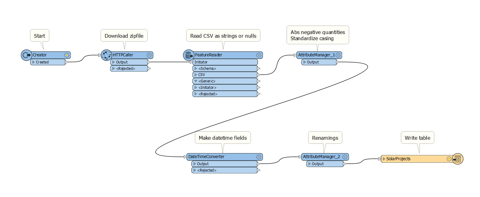
カスタムフォーマットを試用したい場合は、Pro用のArcGIS Data Interoperability拡張機能がインストールされている必要があります。私はPro 2.9を使用してフォーマットを作成し、以前のリリースではテストしていません。発電データのダウンロードと処理には約40分かかります(約130万行)ので注意してください。また、データをマッピングするためにカリフォルニアのZIPコード境界を見つける必要があります。天気レポートフォーマットは数秒で完了します。
ここでの私の本当のメッセージは、Data Interoperability(またはFME)のスキルを持つ一人の人が、大きなボタンで取り込み可能なカスタムフォーマットを作成し、その機能を拡張機能を使う誰とでも共有できるということです。フォーマットを使う人はQuick Importツールについて知っているだけでよく、Data Interoperabilityのトレーニングは必要ありません。
Great thanks Bruce!
Hi Gab
Lets take this off the blog thread, if you can email me as bharold at esri dot com and attach a file I'll take a look.
Hi Bruce,
I tried the EsriJSON reader and didn't get the result of each feature being extracted. I got one point shapefile that is all. It wasn't in the correct geographic location as well.
I just want a tool to read the .markup file, extract the features and then write each out as a point, line and polygon dependent on the content of said .markup file.
Do you know of any other program or script that can do this?
Thanks.
Please try the EsriJSON reader on this file.
I asked the question on the community forum as well as a new user. 🙂
Below is the Notepad ++ for 3 features (point, line and polygon) with the "notes" from ArcGIS Explorer, for example "This is an area" as well as a snippet of what the features look like in the mapping area of the program. The projection is in WMAS:
{"version":"1.0","center":{"x":-10986870.271851821,"y":8242331.5418692939,"spatialReference":{"wkid":102100,"latestWkid":3857}},"scale":3354792.5980079924,"markup":{"elements":[{"arrow":false,"geometry":{"paths":[[[-11220404.649048025,8150437.7533329763],[-11220213.247105539,8151177.2623707335],[-11219830.443220563,8152656.2804462491],[-11218908.231817715,8154126.5989443678],[-11217446.612896994,8155588.2178650908],[-11216341.699129056,8156319.0273254514],[-11215593.490513902,8156319.0273254514],[-11213200.960612934,8157980.7590058204],[-11209164.109426156,8161304.2223665603],[-11204379.03838446,8164436.2500655204],[-11198845.747487843,8167376.8421027008],[-11190554.533199845,8170691.5721667521],[-11179505.395520464,8174380.4402576713],[-11169013.075753514,8176964.3833408887],[-11159077.573898993,8178443.4014164042],[-11144896.408520654,8179365.6128192516],[-11126469.579618488,8179731.0175494328],[-11113758.721498501,8179539.6156069459],[-11106763.834160691,8178791.4069917919],[-11096271.503153976,8176946.9841860961],[-11082281.728478357,8174006.3471898586],[-11072702.909297094,8171248.4125587121],[-11067535.045610188,8168673.1802926548],[-11062932.676933579,8165358.4389888402],[-11058895.803267274,8161304.1886472683],[-11054110.732225576,8155779.6198075768],[-11048577.463808488,8148784.7324697673],[-11042313.397170804,8138840.5085583236],[-11035318.532312524,8125946.9480732465],[-11029611.272347506,8114715.1080287751],[-11025191.617275754,8105144.9884249084],[-11022424.983067211,8096671.0830115834],[-11021311.369721875,8089293.3917888002],[-11020754.563049208,8081002.1887405654],[-11020754.563049208,8071797.4738668799],[-11022598.985854905,8062044.6518979231],[-11026287.831466295,8051743.7228336958],[-11031264.30445048,8042904.4126901906],[-11037528.404807456,8035526.7214674074],[-11043418.378377328,8030002.1526277168],[-11048934.225160094,8026330.7061711177],[-11054093.366790075,8023390.0691748802],[-11058895.803267274,8021180.2416390041],[-11062210.544571087,8019883.9259285787],[-11064037.590701519,8019501.1220436059],[-11071397.894009273,8019309.720101119],[-11084291.45449435,8019309.720101119],[-11092399.955177495,8019866.5267737862],[-11095723.396058705,8020980.1401191205],[-11099412.230430331,8021719.6491568778],[-11103466.458292376,8022085.0538870599],[-11108808.324766979,8023555.3723851778],[-11115437.829854134,8026130.604651235],[-11126852.394743226,8029262.6435899585],[-11143052.019434249,8032951.4892013501],[-11154466.561843811,8035161.3054974629],[-11161096.021971913,8035892.0924782949],[-11169935.320875654,8037736.5152839907],[-11180984.458555033,8040694.5739145502],[-11187979.33465308,8042721.7103251005],[-11190919.94916979,8043817.9245156413],[-11193869.285743425,8045653.6477439404],[-11196827.344373982,8048228.8800099976],[-11201429.713050589,8053388.0441195071],[-11207676.391773246,8061131.1400724724],[-11212278.749210089,8066290.3041819818],[-11215236.785361117,8068865.5364480391],[-11222788.468131829,8076782.6464284612],[-11234933.797522228,8090041.6341232471],[-11241928.673620272,8097410.6145288693],[-11243773.096425969,8098889.5876453277],[-11245617.530471427,8100916.7015763493],[-11247461.975756651,8103491.9563219352],[-11248749.603129443,8105884.4974626657],[-11249480.412589803,8108094.3249985417],[-11249845.817319985,8111034.9619947793],[-11249845.817319985,8114706.4084513783],[-11248192.796456777,8118203.8521202831],[-11244886.754730359,8121527.2930014934],[-11242676.915954717,8123189.0134420991],[-11241563.280129857,8123189.0134420991],[-11241006.462217424,8123189.0134420991]]],"spatialReference":{"wkid":102100,"latestWkid":3857}},"color":0,"filled":true,"notes":"This is an area"},{"arrow":false,"geometry":{"paths":[[[-11071597.995529156,8205700.8408846781],[-11070858.486491399,8205700.8408846781],[-11069379.468415882,8205700.8408846781],[-11066986.927275153,8205144.0342120109],[-11063680.863069206,8204030.4208666757],[-11059443.910362545,8202185.9980609799],[-11054276.069155166,8199610.7657949235],[-11050039.127688266,8197218.2471337207],[-11046733.085961848,8195008.4420773722],[-11043609.735360757,8193346.7216367666],[-11040669.07588499,8192233.0858119037],[-11036432.123178329,8189840.5446711732],[-11030898.877240771,8186169.0982145742],[-11025000.226573031,8181384.0384126408],[-11018736.171175111,8175485.3652653741],[-11013768.409008088,8169586.6921181064],[-11010096.940071961,8163688.0189708378],[-11006416.794037966,8158346.1524962373],[-11002727.970906101,8153561.0926943049],[-11000326.741427738,8149515.5419301288],[-10999213.105602875,8146209.50020371],[-10996081.055424387,8140684.9313640194],[-10990930.590892274,8132941.8354110559],[-10986510.93582052,8126860.4598986981],[-10982822.09020913,8122440.8048269451],[-10980064.166817747,8118577.9564278601],[-10978237.165646371,8115271.9147014422],[-10974557.019612376,8109930.0482268417],[-10969023.728715762,8102552.3570040585],[-10965708.987411946,8097758.5976247285],[-10964612.795700934,8095548.7700888524],[-10961115.363271791,8090763.710286919],[-10955216.690124525,8083403.4182189284],[-10949692.121284835,8077148.0399188763],[-10944541.65675272,8071997.5753867636],[-10940487.406411149,8068317.4293527678],[-10937529.370260119,8066107.6018168917],[-10930343.04726053,8062053.3514753198],[-10918928.437412381,8056154.6783280522],[-10910089.127268877,8052100.4167467151],[-10903825.116830012,8049890.5667313104],[-10889278.54672149,8045836.3163897386],[-10866449.41694331,8039937.6657219995],[-10850980.624192176,8036257.530927768],[-10842872.168468088,8034795.9120070469],[-10836608.090590641,8033882.388941831],[-10832188.39055983,8033516.9617321221],[-10824636.685309589,8032037.9436566066],[-10813952.974839916,8029445.3347152844],[-10806592.705251453,8027418.2207842628],[-10802555.876544204,8025956.6018635407],[-10792428.961507434,8019327.1192559116],[-10776211.960141145,8007529.7729613753],[-10764788.718154186,7998873.1651829602],[-10758159.235546557,7993357.2959206663],[-10754296.353428179,7990042.5546168527],[-10753200.071799055,7988928.9412715174],[-10750624.839532997,7984509.2974395286],[-10746570.656630009,7976783.6231208863],[-10743804.03366123,7972181.2544442788],[-10742324.970626658,7970702.191409708],[-10741585.439109372,7969597.2776417695],[-10741585.439109372,7968866.5131404651],[-10741220.05685872,7967761.6106122918],[-10740489.292357415,7966282.5700572468],[-10739567.092194332,7964812.2403193647],[-10738453.456369469,7963350.6213986427],[-10737713.947331712,7962619.8119382812],[-10737348.565081058,7962619.8119382812],[-10737165.873955732,7962619.8119382812]]],"spatialReference":{"wkid":102100,"latestWkid":3857}},"color":0,"filled":false,"notes":"This is a line"},{"geometry":{"x":-11182071.973168179,"y":7978059.606098094,"spatialReference":{"wkid":102100,"latestWkid":3857}},"color":0,"notes":"This is a point"}],"name":"Markup","version":"1.0"}}
The .markup file will have to be readable somehow to make any progress, I would have to ask around what it is built from. Can you open it with Notepad++ and paste in a few lines? Your challenge may be a good topic for a question on the experts forum: https://community.safe.com/s/knowledge-base
Hi, I didn't get further than the reader input. There isn't a .markup format to import, soooo I may need someone to make a file input if that is possible? I don't know enough to get further than trying file formats that already exist on the provided formats. Thanks for replying so quickly.
I should also mention I am trying this totally offline, that is importing the .markup file from windows explorer and not a hosted feature on ArcGIS Online. I will be using the resulting written feature class or shapefile in ArcGIS Pro 2.9.1.
If there is a document that can give some guidance on how to make the reader file. I am willing to try it.
Thanks very much.
Did the custom formats in this blog post fail or another you have? If it is one of yours please open a support call and share the fds file and error details and we can take a look. If its the ones in this post please share the error details and confirm the release of ArcGIS Pro you are using - thanks.
I am a new user of the Data Interoperability Extension and I am happy to see it has so many functions. I tried to use the custom format but was unsuccessful. I am trying to extract the features (point, line and polygon) from a .markup file from ArcGIS Explorer to feature classes in a geodatabase or even shapefiles for CAD users. I know that this program is on the way out but it will be good to have the ability to do this. Any assistance is appreciated, thanks
サインインしたメンバーは投稿、更新のフォローなどができます。初めてですか?無料アカウントを登録してください。
Find useful guides, FAQs, and documents to help you navigate and make the most of Esri Community.