Hi,
I'm loading data from a GeoJSON object in python. I'm sure I am properly assigning my point coordinates in "geometry" key like this:
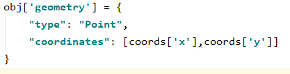
and creating a featureSet from the cases dict (GeoJSON) and load it to my hosted feature layer in AGOL.

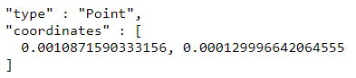
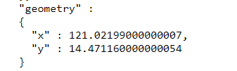
But in my AGOL's map viewer, all points are concentrated in [0,0] coordinates. Checking the service URL, whenever I query the features and return them in HTML or in JSON format, it shows the correct (x,y) geometry. But when I return them in geojson, it shows wrong (x,y) values. Any idea how this is even possible? Thank you!
JSON:
HTML:

GeoJSON: