Hello everyone,
I have the attached file (AddRecord_V6.html) which I will paste into the thread at the bottom. It works fine in the JavaScript sandbox environment. I have recently tried to break this file out into separate files (.html, .js, .css) to see if I can get this working from the web server on my PC (localhost).
Of course it's not working. What I see is:
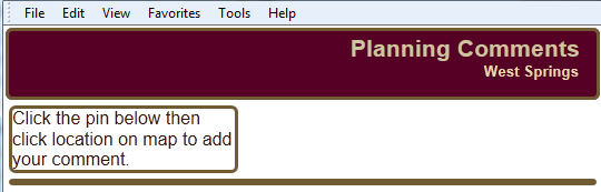
I'm confident that 2 things that need to be changed when moving away from the Sandbox environment are:
- Proxy
- I have been trying to follow (https://developers.arcgis.com/javascript/jshelp/ags_proxy.html) to get the proxy working. But I'm not getting it. Is there any documentation that can help walk someone more explicitely through the steps?
- Irregardless, I don't think that the proxy issue would have anything to do with the map not displaying above.
- Dojo
- I've been reading on the dojo site dojotoolkit.org, trying to get that set up. The easiest method seems to be to reference a CDN.
Basically I don't know what I'm missing to get this working. Any direction greatly appreciated. The index.zip contains the individual files broken out. Below is the code from AddRecord_V6.html
Thanks all!
<!DOCTYPE html>
<html>
  <head>
    <meta http-equiv="Content-Type" content="text/html; charset=utf-8">
    <!--The viewport meta tag is used to improve the presentation and behavior
    of the samples on iOS devices-->
    <meta name="viewport" content="initial-scale=1, maximum-scale=1,user-scalable=no">
    <title>Multiple Attribute Inspectors</title>

    <link rel="stylesheet" href="http://js.arcgis.com/3.10/js/dojo/dijit/themes/claro/claro.css">
    <link rel="stylesheet" href="http://js.arcgis.com/3.10/js/esri/css/esri.css">
    <style>
      html,body {
        height:100%;
        width:100%;
        background-color:#FFF;
        font-family:Kimberley, sans-serif;
        margin:0;
        padding:0;
      }

      #header {
        padding-top:4px;
        padding-right:15px;
        background-color:#570026;
        color:#CCC59E;
        font-size:16pt;
        text-align:right;
        font-weight:700;
        height:55px;
        margin:2px;
      }

      #subheader {
        font-size:small;
        color:#E8D9AC;
        text-align:right;
        padding-right:1px; /*20px;*/
      }

      #leftPane {
        margin:5px; /*added this, seems to align #leftPane & #map a bit nicer*/
        width:200px; /*300px;*/
        color:#3C1700;
        background-color:#FFF;
      }

      #HomeButton {
         position: absolute;
         top: 95px;
         left: 20px;
         z-index: 50;
         }

    #LocateButton {
      position: absolute;
      top: 129px;
      left: 20px;
      z-index: 50;
    }

      #map {
        margin:5px;
        padding:0px;
      }
      .templatePicker {
        border: none !important;
        height: 93% !important;
      }
      .templatePicker .grid .groupLabel{ /* This css will remove the template picker title*/
        display:none;                      /* "TRPLCWH.Comments"*/
      }
      .templatePicker .itemLabel{ /*makes text orange*/
        color:black;
      }
      .roundedCorners{
        border:solid 3px #705B35;
        border-radius:6px;
      }
      .shadow {
        -webkit-box-shadow: 0 8px 6px -6px #999;
        -moz-box-shadow: 0 8px 6px -6px #999;
        box-shadow: 0 8px 6px -6px #999;
      }

      .esriAttributeInspector {
        height:283px;
        /*width:400px;*/
        overflow: hidden; /* makes it so that the vertical scroll bar does not show up */
      }

      .esriAttributeInspector .atiLayerName {
        display:none;
      }


      .esriAttributeInspector .atiField {
        font-family: "Verdana";
        font-size: 1em;
        width: 300px;
      }

      .esriAttributeInspector .atiTextAreaField {
        font-family: "Verdana";
        font-size: 1em;
        width: 296px;
      }


      .saveButton {
        padding-left:45px;
         margin:0px;width:16px; height:16px;
       }
    </style>

    <script src="http://js.arcgis.com/3.10/"></script>
    <script>
      require([
          "esri/map", "esri/dijit/HomeButton", "esri/dijit/LocateButton", "esri/layers/FeatureLayer", "esri/dijit/AttributeInspector", "esri/graphic", "esri/config",
          "dojo/dom", "dojo/on", "dojo/_base/array", "esri/toolbars/draw", "dojo/dom-construct",
          "dojo/parser", "esri/toolbars/draw", "esri/dijit/editing/TemplatePicker", "esri/dijit/AttributeInspector",
          "dijit/form/Button", "dijit/layout/BorderContainer", "dijit/layout/ContentPane",
          "dojo/domReady!"
        ], function(
          Map, HomeButton, LocateButton, FeatureLayer, AttributeInspector, Graphic, esriConfig,
          dom, on, array, Draw, domConstruct,
          parser, draw, TemplatePicker, AttributeInpsector,
          Button
        ) {

          parser.parse();

          esriConfig.defaults.io.proxyUrl = "/proxy";

          var map, updateFeature;

          map = new esri.Map("map", {
            basemap: "streets",
            center: [-114.2, 51.06],
            zoom: 12
          });

          var home = new HomeButton({
            map: map
          }, "HomeButton");
          home.startup();

          var geoLocate = new LocateButton({
            map: map
          }, "LocateButton");
          geoLocate.startup();

          on(map, "layers-add-result", initEditing);

          var pointLayer = new FeatureLayer("http://gismap2.calgary.ca/arcgis/rest/services/LUPP_Testing/CitizenComments/FeatureServer/0", {
            mode: FeatureLayer.MODE_SNAPSHOT,
            outFields: ["*"]
          });

          map.addLayers([pointLayer]);


          function initEditing(results) {
            var layers = [results.layers[0].layer];

            var templatePicker = new TemplatePicker({
              featureLayers: layers,
              rows: 'auto',
              columns: 'auto',
              grouping: true
            }, "templatePickerDiv");

            templatePicker.startup();

            var drawToolbar = new Draw(map);

            var selectedTemplate;

            on(templatePicker, "selection-change", function() {
              selectedTemplate = templatePicker.getSelected();

              if (selectedTemplate) {
                switch (selectedTemplate.featureLayer.geometryType) {
                case "esriGeometryPoint":
                  drawToolbar.activate(esri.toolbars.Draw.POINT);
                  break;
                }
              }
            });

            on(drawToolbar, "draw-end", function(geometry) {
              updateFeature = geometry;
              console.log(updateFeature);

              if (map.infoWindow.isShowing) {
                map.infoWindow.hide();
              }

              drawToolbar.deactivate();

              var fieldAttributes = layerFieldToAttributes(selectedTemplate.featureLayer.fields);
              var newAttributes = dojo.mixin(fieldAttributes, selectedTemplate.template.prototype.attributes);
              var newGraphic = new Graphic(geometry, null, newAttributes);

              var layerInfos = [{
                'featureLayer': selectedTemplate.featureLayer,
                'isEditable': true,
                'showAttachments': true,
                fieldInfos: [
                  { fieldName: "NAME", label: "NAME:", isEditable: true },
                  { fieldName: "EMAIL", label: "EMAIL:", isEditable: true },
                  { fieldName: "PHONE", label: "PHONE:", isEditable: true },
                  { fieldName: "CITIZEN_COMMENT", label: "COMMENT:", isEditable: true, 'stringFieldOption': 'textarea' }
                ]
              }];

              var attInspector = new AttributeInspector({
                layerInfos: layerInfos
              }, domConstruct.create("div"));

              var saveButton = new Button({ label: "Save", "class": "saveButton"});
                domConstruct.place(saveButton.domNode, attInspector.deleteBtn.domNode, "after");

                saveButton.on("click", function(){
                map.infoWindow.hide();
              });

              selectedTemplate.featureLayer.applyEdits([newGraphic], null, null, function() {
                var screenPoint = map.toScreen(getInfoWindowPositionPoint(newGraphic));

                map.infoWindow.setContent(attInspector.domNode);
                map.infoWindow.resize(400,400); //(325, 185);
                map.infoWindow.show(screenPoint, map.getInfoWindowAnchor(screenPoint));

                templatePicker.clearSelection();
              });

              on(attInspector, "attribute-change", function(evt) {
                  evt.feature.attributes[evt.fieldName] = evt.fieldValue;
                evt.feature.getLayer().applyEdits(null, [evt.feature], null);
              });

              //delete a point
              on(attInspector, "delete", function(evt) {
                evt.feature.getLayer().applyEdits(null, null, [evt.feature]);
                map.infoWindow.hide();
              });
            });
          }
        //removing this code makes it so that the info window does not open
        function getInfoWindowPositionPoint(feature) {
          var point;
          switch (feature.getLayer().geometryType) {
          case "esriGeometryPoint":
            point = feature.geometry;
            break;
          }
          return point;
        }

        //required for info window
        function layerFieldToAttributes(fields) {
          var attributes = {};
          dojo.forEach(fields, function(field) {
            attributes[field.name] = null;
          });
          return attributes;
        }
     });
    </script>
  </head>

  <body class="claro">
    <div id="mainWindow" data-dojo-type="dijit.layout.BorderContainer" data-dojo-props="design:'headline',gutters:false"
     style="width:100%; height:100%;">
      <div id="header" class="roundedCorners" data-dojo-type="dijit.layout.ContentPane" data-dojo-props="region:'top'">
        Planning Comments
        <div id="subheader">
        West Springs
        </div>
      </div>
      <div data-dojo-type="dijit.layout.ContentPane" data-dojo-props="region:'left'" class="roundedCorners" id="leftPane">
        <div>Click the pin below then click location on map to add your comment.</div>
        <div id="templatePickerDiv"></div>
      </div>
      <div id="map" class="shadow roundedCorners" data-dojo-type="dijit.layout.ContentPane" data-dojo-props="region:'center'">
       <div id="HomeButton"></div>
       <div id="LocateButton"></div>
      </div>
    </div>
  </body>

</html>

