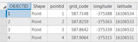
When attempting to calculate geometry for X coord and Y coord in ArcMap and then in ArcGIS Pro the results for the X coord are different, (Y coord results are the same). See the attached jpegs with results. Both were calculated in interactive sessions. I believe the results from ArcMap are correct after comparing to surveyed values. The end result are calculations from geographic coordinates to UTM Zone 15N, NAD83, feet. So, I'm hoping to run a python script that will loop thru 1,455 layers and get the "right" results. I have tried running a script in ArcGIS Pro but get erroneous X coord results. When running the same script in ArcMap (below) the error message shows up. Any help would be appreciated!

<SPAN class="operator token">>></SPAN><SPAN class="operator token">></SPAN> <SPAN class="keyword token">import</SPAN> arcpy
<SPAN class="operator token">>></SPAN><SPAN class="operator token">></SPAN> arcpy<SPAN class="punctuation token">.</SPAN>env<SPAN class="punctuation token">.</SPAN>overwriteOutput <SPAN class="operator token">=</SPAN> <SPAN class="number token">1</SPAN>
<SPAN class="operator token">>></SPAN><SPAN class="operator token">></SPAN> outrastertopoint <SPAN class="operator token">=</SPAN> r<SPAN class="string token">"S:/General-Offices-GO-Trans/SLR-Mapping/GIS_Projects_2018/Smart_T_Line_Model/geodata/RASTERTOPOINT_TEST2.gdb/"</SPAN>
<SPAN class="operator token">>></SPAN><SPAN class="operator token">></SPAN> arcpy<SPAN class="punctuation token">.</SPAN>env<SPAN class="punctuation token">.</SPAN>workspace <SPAN class="operator token">=</SPAN> outrastertopoint
<SPAN class="operator token">>></SPAN><SPAN class="operator token">></SPAN> featureClassList <SPAN class="operator token">=</SPAN> arcpy<SPAN class="punctuation token">.</SPAN>ListFeatureClasses<SPAN class="punctuation token">(</SPAN><SPAN class="punctuation token">)</SPAN>
<SPAN class="operator token">>></SPAN><SPAN class="operator token">></SPAN> <SPAN class="keyword token">for</SPAN> featureClass <SPAN class="keyword token">in</SPAN> featureClassList<SPAN class="punctuation token">:</SPAN>
<SPAN class="punctuation token">.</SPAN><SPAN class="punctuation token">.</SPAN><SPAN class="punctuation token">.</SPAN> arcpy<SPAN class="punctuation token">.</SPAN>management<SPAN class="punctuation token">.</SPAN>CalculateGeometryAttributes<SPAN class="punctuation token">(</SPAN>featureClass<SPAN class="punctuation token">,</SPAN> <SPAN class="string token">"X_coord POINT_X;Y_coord POINT_Y"</SPAN><SPAN class="punctuation token">,</SPAN> None<SPAN class="punctuation token">,</SPAN> None<SPAN class="punctuation token">,</SPAN> <SPAN class="string token">"PROJCS['NAD 1983 UTM Zone 15N_1',GEOGCS['GCS_North_American_1983',DATUM['D_North_American_1983',SPHEROID['GRS_1980',6378137.0,298.257222101]],PRIMEM['Greenwich',0.0],UNIT['Degree',0.0174532925199433]],PROJECTION['Transverse_Mercator'],PARAMETER['False_Easting',500000.0],PARAMETER['False_Northing',0.0],PARAMETER['Central_Meridian',-93.0],PARAMETER['Scale_Factor',0.9996],PARAMETER['Latitude_Of_Origin',0.0],UNIT['Feet',0.3048]]"</SPAN><SPAN class="punctuation token">)</SPAN>
<SPAN class="punctuation token">.</SPAN><SPAN class="punctuation token">.</SPAN><SPAN class="punctuation token">.</SPAN>
Runtime error
Traceback <SPAN class="punctuation token">(</SPAN>most recent call last<SPAN class="punctuation token">)</SPAN><SPAN class="punctuation token">:</SPAN>
File <SPAN class="string token">"<string>"</SPAN><SPAN class="punctuation token">,</SPAN> line <SPAN class="number token">1</SPAN><SPAN class="punctuation token">,</SPAN> <SPAN class="keyword token">in</SPAN> <SPAN class="operator token"><</SPAN>module<SPAN class="operator token">></SPAN>
TypeError<SPAN class="punctuation token">:</SPAN> <SPAN class="string token">'NoneType'</SPAN> object <SPAN class="keyword token">is</SPAN> <SPAN class="operator token">not</SPAN> iterable
<SPAN class="operator token">>></SPAN><SPAN class="operator token">></SPAN> <SPAN class="line-numbers-rows"><SPAN></SPAN><SPAN></SPAN><SPAN></SPAN><SPAN></SPAN><SPAN></SPAN><SPAN></SPAN><SPAN></SPAN><SPAN></SPAN><SPAN></SPAN><SPAN></SPAN><SPAN></SPAN><SPAN></SPAN><SPAN></SPAN></SPAN>

