I am using ArcGIS Pro 2.4.1. When I use the symbology properties to "Classify" my floating point raster with the "Quantile" method, the label changes from being a single ≤ symbol to two symbols <= ...after reducing the format of the labels to round to 1 decimal place. This seems like a bug. I believe that my only solution is to go back and manually edit these back to the single symbol of ≤.
From:
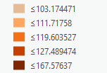
To:
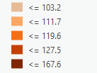
Any advice would be welcome. I now have about 300 layers to manually correct.
Thanks,
Roland



