Addressing Utility Damage and Maps
By Tom DeWitte and Tom Coolidge
Every day, thousands of subsurface utility engineering (SUE) and 811 locating technicians work to find, identify, mark, and document the locations of underground utilities, yet underground utilities are still being hit. The Common Ground Alliance (CGA) estimates that damage to underground utilities costs the U.S. economy at least $30 billion annually.
In its 2026 open letter, the National Utility Locating Contractors Association (NULCA) explains that today’s 811 ecosystem is under strain due to multiple underlying issues. One of those identified issues is mapping. A portion of the letter states the following:
The CGA 2024 Damage Information Reporting Tool (DIRT) DIRT Report documents that marking accuracy failures and facility identification issues remain among the most persistent root causes of damages in this industry. Locating professionals have repeatedly and consistently described marks placed exactly where records indicated, only for excavation to reveal infrastructure in a completely different location. Not a few feet off. On the wrong side of the road. Crossing at the wrong block. Or not shown in the records at all.
The CGA DIRT data reinforces the point: in 2024, there were 196,977 unique reported damages, and locating and mapping practices remained a major root-cause category (25%), alongside excavation practices (24%). In other words, even when people call 811 and excavators follow procedures, if the maps and data used by locators to determine where to start locating are inaccurate or missing, damage will occur.
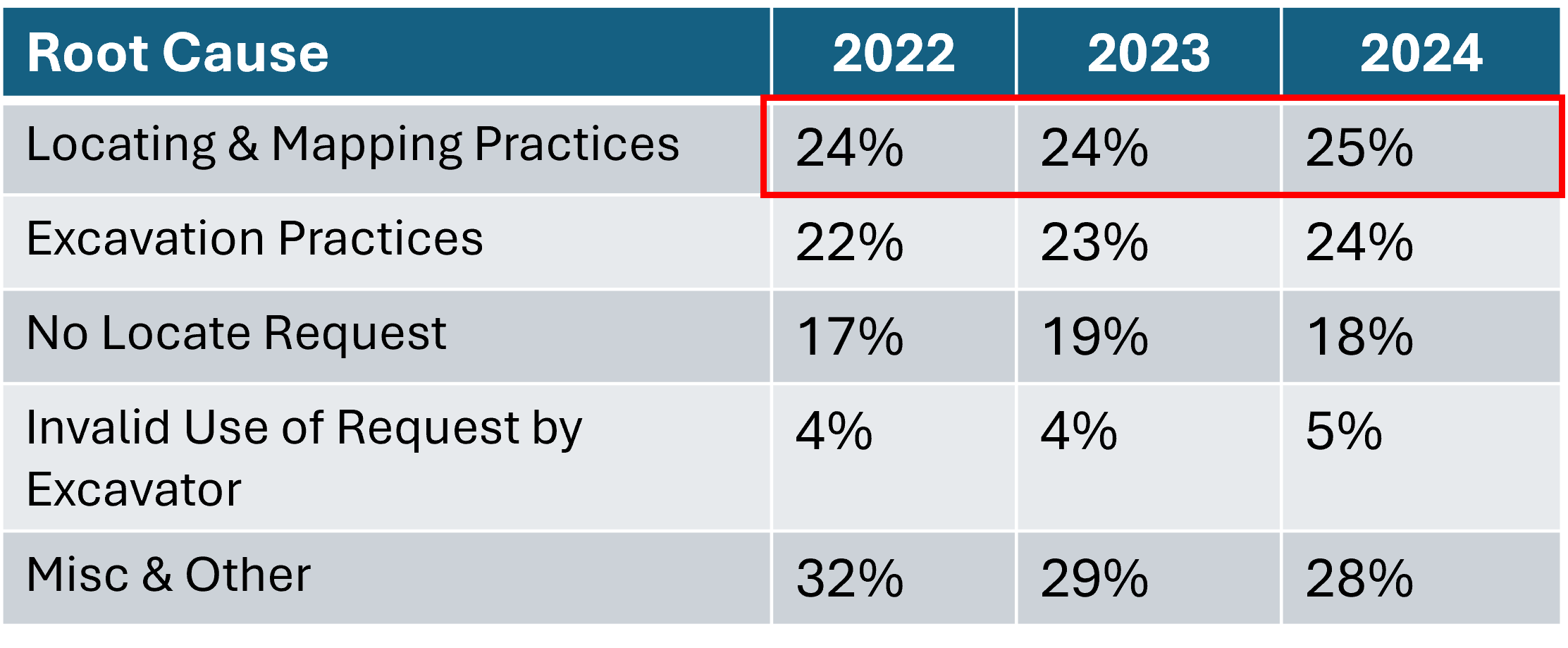
The frustrating part is that the root cause, “locating and mapping practices,” is not declining year over year. It is increasing as a percentage of all damages. These preventable damages, caused by utility-controlled procedures and practices, have consequences. When a locate mark is off by a few feet, when a map is out of date, or when a non-locatable asset is left undocumented, risk accumulates quietly until it becomes a strike, an outage, or worse.
A new approach is needed.
A New Approach: GNSS Utility Locating Hardware and ArcGIS
There are many reasons why the maps used by locators and subsurface utility professionals are spatially inaccurate, why some utility pipes and wires are unmapped, and why existing assets are unlocatable. There is also a common solution to these historical problems: enhance the locating-and-marking task so it also becomes a mapping task.
Instead of treating locating as a “temporary paint” activity and high-accuracy mapping as a separate field activity, smartly combine the two into a single field activity. Integrate high-accuracy GNSS and GIS data collection with utility locating hardware.
To bring this new approach to the underground locating industry, Esri has partnered with three leading utility locate hardware manufacturers: Radiodetection, Subsite, and Vivax-Metrotech.

GNSS Enhanced Utility Locating Hardware
The first part of this integration is already complete and available to the subsurface industry. Radiodetection, Subsite, and Vivax-Metrotech all provide utility-locating hardware with a built-in GNSS receiver. These GNSS receivers are RTK-capable, meaning they can capture location with centimeter-level horizontal accuracy.
Fixing the Data Plumbing
The second part is to connect these handheld devices with a smartphone or tablet via Bluetooth.
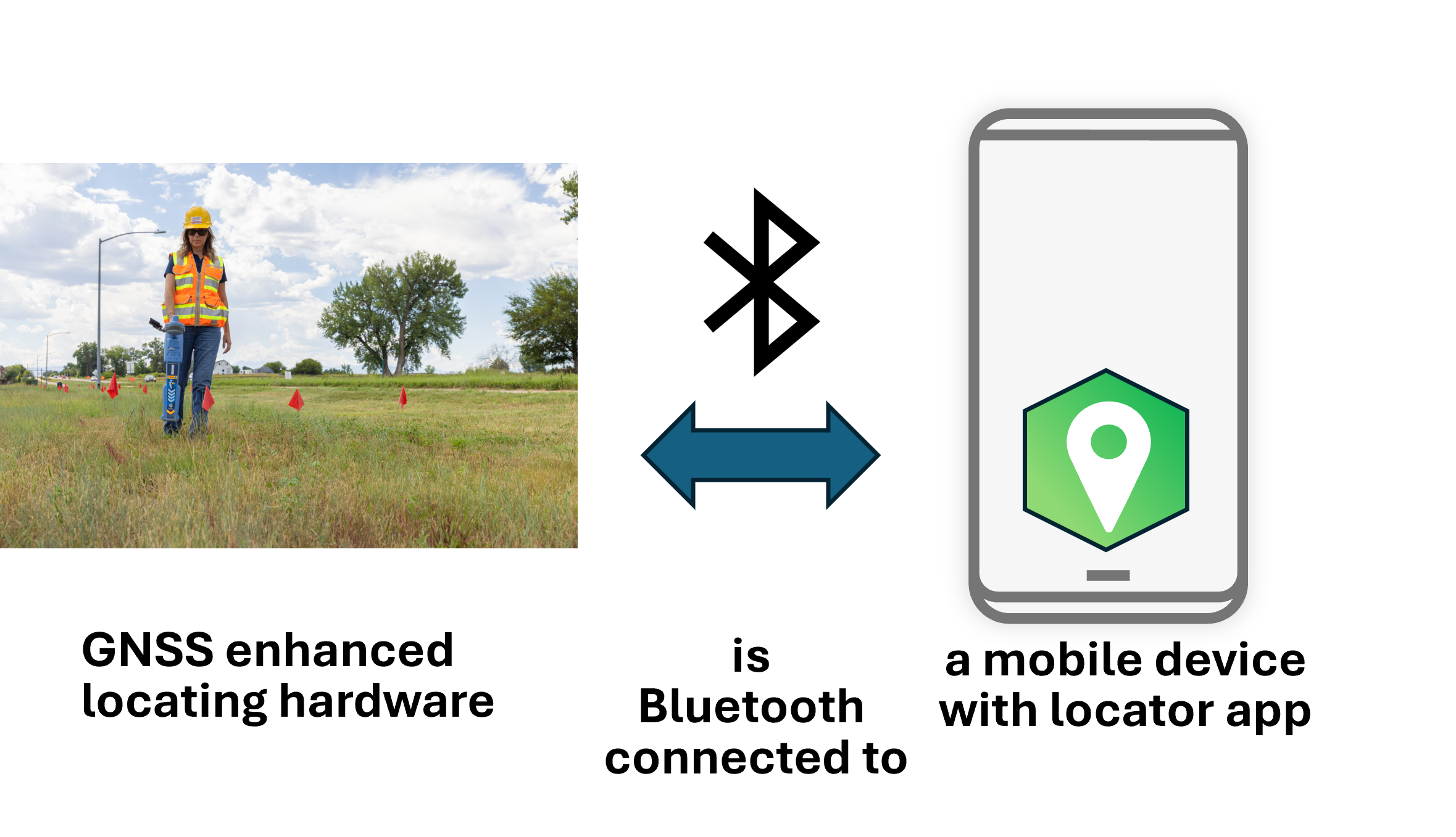
All three hardware manufacturers provide Bluetooth-enabled utility locating devices.
The third part is to integrate ArcGIS into this solution.
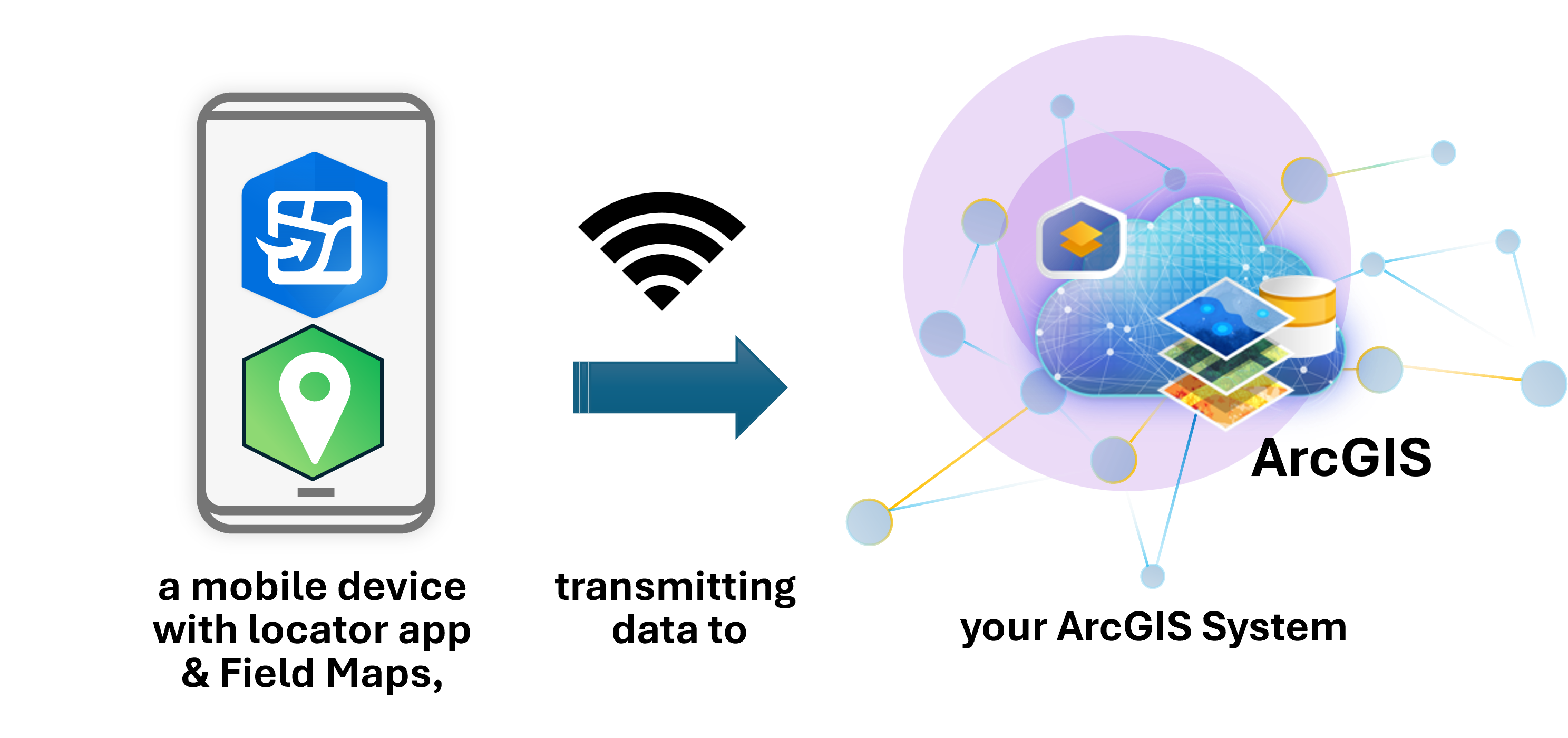
This third part is in joint development and is expected to be available this year.
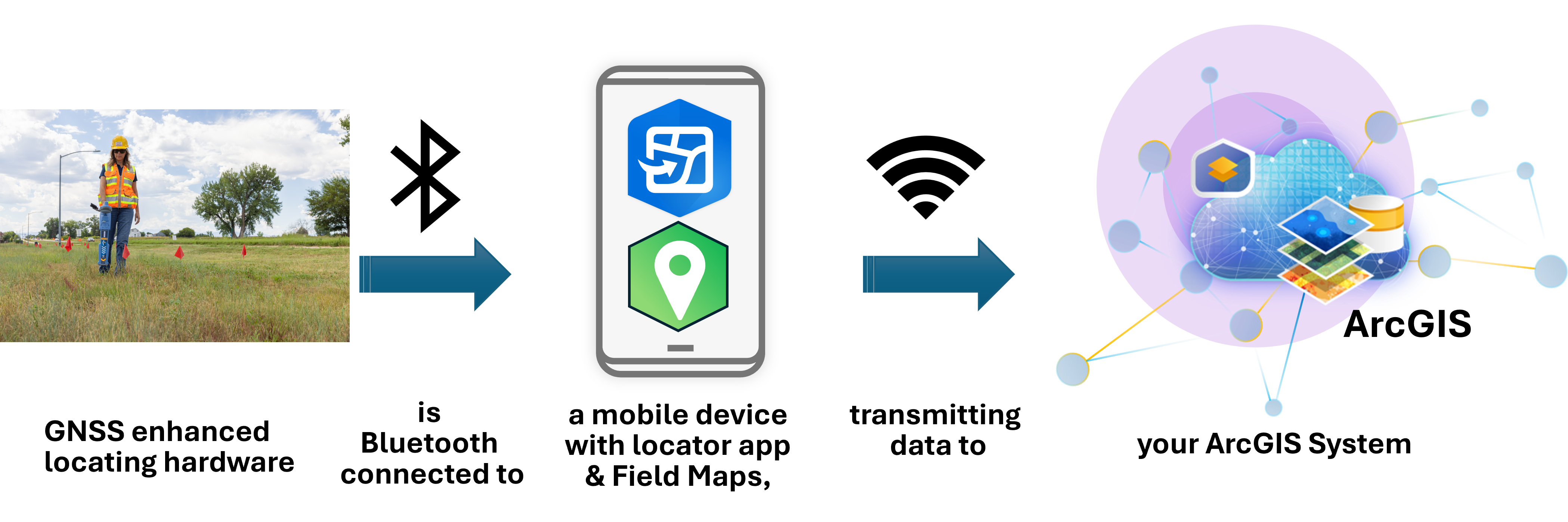
When the data plumbing is fixed, locators will be able to leverage previously collected data to improve accuracy and productivity. Office staff in the mapping department will then be able to receive spatially accurate information about buried assets as a byproduct of the locate activity. This field-generated data can be used to identify missing assets and correct mislocated assets.
What Changes when Locating and ArcGIS are integrated?
When locating and ArcGIS are integrated, the marking and mapping become a singular activity. While the locator is identifying the location and marking the buried utility, the integrated hardware/software is capturing and transmitting location information to ArcGIS.
For subsurface utility mapping activities at the beginning of a project, the current two-person team for marking and mapping can be replaced by a single field technician with a single device. That is an immediate doubling of field-worker productivity and a reduction in field-hardware costs.
For office mappers, this integration will finally provide a consistent source of map revisions long desired, but current methods are difficult to maintain.
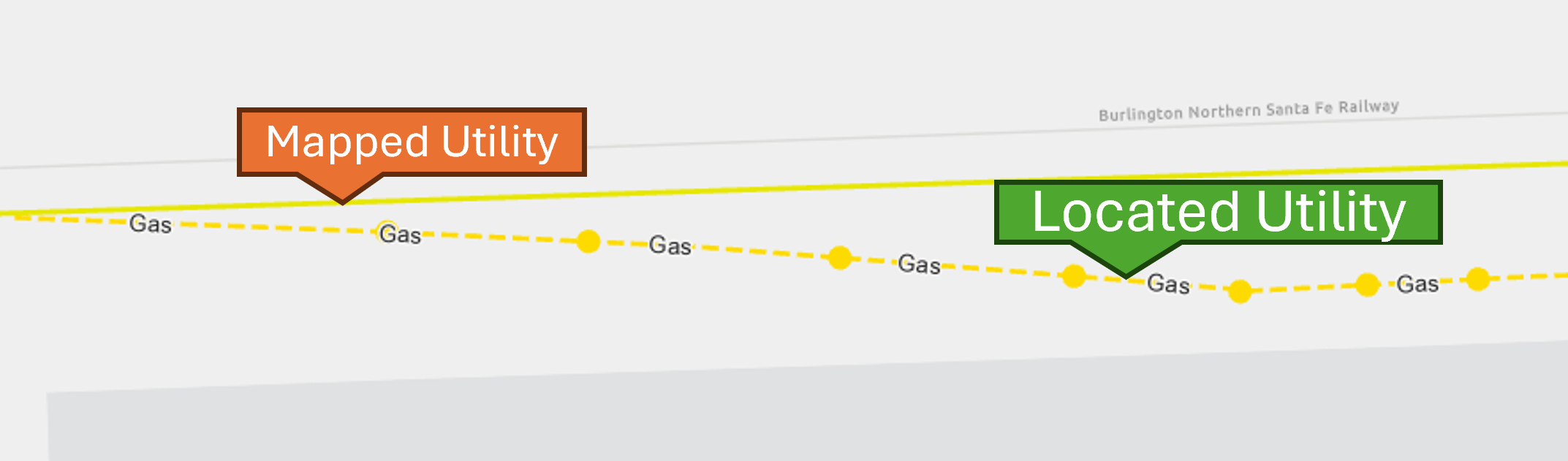
Now, office mappers will have the information needed to identify where and how the mapping of an existing utility asset needs to be spatially adjusted. Over time, the map data will continue to improve and eventually eliminate statements such as, “The map had the utility on the wrong side of the street.”
For locators, this will provide better maps of utilities, allowing them to find and mark buried utilities more accurately.
Lastly, integrating GNSS-enhanced locating hardware with ArcGIS will provide a new ability to locate “unlocatables”. When a tracer wire cannot be traced traditionally, crews can use a previously GNSS-located line mapped in ArcGIS Field Maps together with their GNSS-enhanced locating device to walk the line back and accurately mark the utility.
Reducing Damages to Utilities
The purpose of this integration is to directly and positively address a root cause of damage to buried utilities: damage caused by buried utility pipes and wires that were originally mapped inaccurately or are currently missing from published maps.
Fixing the data plumbing between the GNSS-enhanced utility locating device and ArcGIS enables a new stream of field data that provides utility mapping departments with feedback on where legacy mapped utilities require review and revision.
This integrated capability will provide subsurface utility mappers and locators with better mapping data. Better map data will help field professionals more accurately mark the location of buried pipes and wires.
Integrating GNSS-enhanced locating hardware with ArcGIS through Field Maps is a practical step utilities can take to tighten the feedback loop between what’s found in the field and what’s trusted in the map. When marking and mapping become a single, connected workflow, damage caused by mis-mapped utilities will finally decrease.
PLEASE NOTE: The postings on this site are our own and don't necessarily represent Esri's position, strategies, or opinions.
