Hi all. Just wondering if anybody has insight into the 3079 error that returns the description:
"Domain exists. The domain ESRI_FIX_TYPE_DOMAIN already exists but has a conflicting definition. Make sure the fields using the domain have the same field type"
It causes layers to not load in FieldMaps. Weirdly, despite the fact I set up layers in exactly the same way each time, the 3079 error appears random. In my case, I set up three data collection layers: Points, Lines, Areas. Each has high-precision GPS enabled. Each of the layers throws up a problem - usually one or two at a time.
I've worked out that it is the GNSS fields that ESRI itself creates when you tick the GPS metadata box when creating layers. A workaround at the moment seems to be deleting the offending field.
This isn't ideal and a waste of time. Does anybody have any idea why this ESRI-created field does this - it seems a bit ridiculous.
Cheers
EDIT: I noticed that maps based on an earlier template (Mar 2025) did not have this problem. I think I have narrowed it down to the esrignss_fixtype domain list. Old versions have six values:
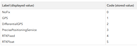
New maps/templates with GNSS enabled have five values:
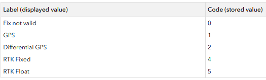
I don't know why, but the new values seems to be causing the issue, as deleting this whole field fixes the domain issue...
Any insights from people smarter than me?

