Hi,
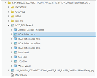
I'm trying to follow the solar park classification deep learning model (Use the model—ArcGIS pretrained models | Documentation), and I am wondering how to download or access the sentinel-2 imagery that the model depends on. It seems like there's a specific "Bottom of Atmosphere" reflectance layer to use, and I have to import the ".SAFE" files to create the mosaic. However, I don't see any instructions on how to download this package of files. When I try to download Sentinel-2 data generally, I can grab RGB tifs, but it's not clear to me how to get the package of data the instructions reference:
Thanks in advance for any guidance anyone can provide!


