Hello,
I'm wondering if anyone has information on how error text is determined when writing Arcade code. Here's an example of an error message I find misleading:

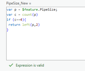
The above code is incorrect because I actually need two equal signs on line 3, but the error message return is "close parenthesis expected." It's possible I'm not sure what the Arcade language is actually evaluating, but this is not the only case (or ESRI product) where Arcade error messages have been really difficult to interpret and find the root issue. Is this something ESRI has documentation on that I just haven't found? Possibly an area to submit an idea to improve the error messages?


