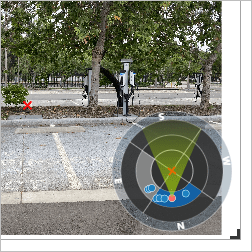
When performing any kind of property or infrastructure inspection, photos are necessary for data capture and decision making, while GIS is integral for mapping and analysis. However, it can be difficult to incorporate photos taken from many different angles into GIS. Oriented Imagery, a widget compatible with multiple ArcGIS products, solves this problem by allowing you to manage and visualize imagery taken from any angle or vantage point. Oriented Imagery can also be used in damage assessments, environmental studies, asset inventories, or any GIS workflow that uses photo imagery.
In this lesson, you'll perform a photographic site inspection using GIS. First, you'll create a feature layer to contain images collected in the field. Then, you'll make an ArcGIS QuickCapture project and enable Oriented Imagery so field workers can take photos of your site using their mobile devices. After capturing a few photos, you'll display them in an ArcGIS Experience Builder web app so you can explore the results from your computer.
You'll use ArcGIS Experience Builder, which allows you to build custom web layouts without writing any code. Your goal is to build a layout that meets the following criteria:
Signed in members can post, follow updates, and more. New here? Register a free account.
Find useful guides, FAQs, and documents to help you navigate and make the most of Esri Community.