- Home
- :
- All Communities
- :
- Products
- :
- ArcGIS Online
- :
- ArcGIS Online Questions
- :
- Printing options
- Subscribe to RSS Feed
- Mark Topic as New
- Mark Topic as Read
- Float this Topic for Current User
- Bookmark
- Subscribe
- Mute
- Printer Friendly Page
Printing options
- Mark as New
- Bookmark
- Subscribe
- Mute
- Subscribe to RSS Feed
- Permalink
- Report Inappropriate Content
- Mark as New
- Bookmark
- Subscribe
- Mute
- Subscribe to RSS Feed
- Permalink
- Report Inappropriate Content
1. Clicking My Organization
2. Click Edit Settings
3. Click Utility Services Tab
4. Change the url to whatever your printer service is.
You can set up different templates that your printer service accesses by viewing the ArcGIS Help.
- Mark as New
- Bookmark
- Subscribe
- Mute
- Subscribe to RSS Feed
- Permalink
- Report Inappropriate Content
And what if we do not have ArcServer?
Many, many of us do not have that and did not expect to need that to merely print something in a usable format...
I guess this is still a problem a year and a half later...since most questions like this have no answers or point people to ArcServer.
- Mark as New
- Bookmark
- Subscribe
- Mute
- Subscribe to RSS Feed
- Permalink
- Report Inappropriate Content
Jennifer,
You are right. There are a lot of functions you still need a server for. Earlier I have read a question about using your own address locators in AGOL. Again you need a server for that.
It seems that ESRI is slowly transitioning into the AGOL age, with emphasize on slowly 
Tim
- Mark as New
- Bookmark
- Subscribe
- Mute
- Subscribe to RSS Feed
- Permalink
- Report Inappropriate Content
So frustrating.
We have 3 people. And we have AGOL Org, BA Desktop, ArcMap and a few extensions. That's not a small amount of money.
And every time we try to do something that we *used* to be able to do with the products we replaced or have become obsolete we can't.
- Mark as New
- Bookmark
- Subscribe
- Mute
- Subscribe to RSS Feed
- Permalink
- Report Inappropriate Content
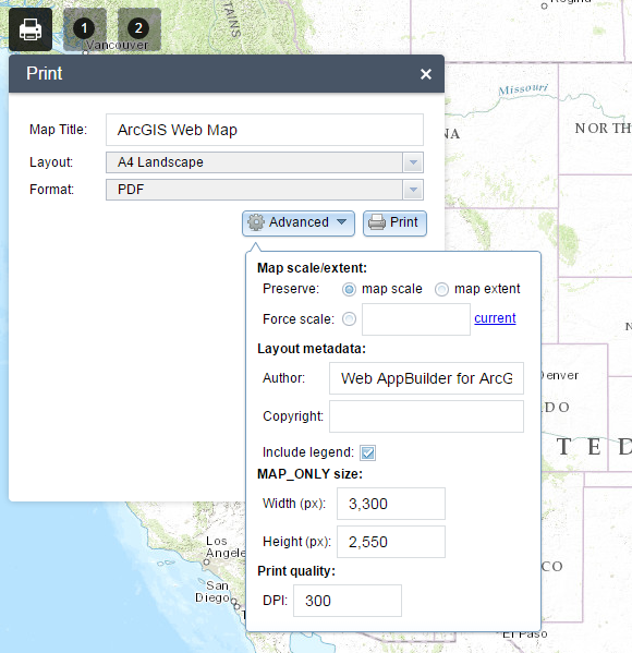
Jennifer Minnick did you try the WebAppbuilder yet? It has a lot more options for printing.
- Mark as New
- Bookmark
- Subscribe
- Mute
- Subscribe to RSS Feed
- Permalink
- Report Inappropriate Content
Tim -
I definitely will... the idea was to try to allow a larger number of non-GIS like people (via AGOL Org) the ability to geocode and make simple maps (a la MapPoint) to put into other documents (usually PowerPoint or Word - sad to say).
It seems counter-intuitive that I would have to create an App to allow my internal employees to place points and make a print out. But if that's what it takes to do this simple thing without ArcServer I'm game to try it out. The telling moment will be if I discover that I can map an app from which they can print but they can't import and geocode points.
But perhaps that's my inability to program shining through 
Thanks for the suggestion...
- Mark as New
- Bookmark
- Subscribe
- Mute
- Subscribe to RSS Feed
- Permalink
- Report Inappropriate Content
I assume that the geocoding service that ESRI offers is not accurate enough? It will also cost alot of credits to use it. Would they have spreadsheets of lat/long data or addresses? If it is lat/long data then there is an easy way to plot things on a map.
If it is ok to use the geocoder that ESRI provides, you could always train them to look for an address or lat/long and then use the draw tool to add a point. I know this is not optimal but it could do the job.
Just let me know what exactly they would do.
- Mark as New
- Bookmark
- Subscribe
- Mute
- Subscribe to RSS Feed
- Permalink
- Report Inappropriate Content
And apparently you cannot...
- Mark as New
- Bookmark
- Subscribe
- Mute
- Subscribe to RSS Feed
- Permalink
- Report Inappropriate Content
The ideal is trying to replicate what Microsoft MapPoint did...
Put in a list of addresses (csv - just explaining that will be a trial) and get a map and print it - all points on one map - sometimes labeled and sometimes not. Real estate survey maps - options, competitors, etc. Aerial or tiled map map.
OR
Put in a list of addresses (or lat/longs from another source) and make an image of each point separately (like a map book in ArcMap). These are also real estate survey maps for offices all over the country and some international locations.
These people are not GIS people and are not going to, for the most part, use an alternate service to get lat/long and one by one geocoding is not very useful either when you have 30 locations and the broker wants it yesterday (which is why I'm trying to find a solution for them). The ESRI geocode is fine and we'd have to accommodate for the ridiculous credit usage system if this were to be embraced by our employees for these "simple" maps.
I know I sound maybe defeated. I've been using ESRI products for something like 18+ years and I'm a fan but this current iteration and the move back to the credit system on top of everything else is frustrating. Plus, my company isn't buying into this completely so I'm cobbling stuff together and I don't know everything about everything ESRI Programming is useful but it just doesn't stick with me (believe me I've tried!) and there is no one else here who can program for us and we can't hire anyone...
But I will keep exploring and trying to learn programming!