Turn on suggestions
Auto-suggest helps you quickly narrow down your search results by suggesting possible matches as you type.
Cancel
- Home
- :
- All Communities
- :
- Industries
- :
- Water Resources
- :
- Water Resources Questions
- :
- Adjust Flow Direction in Lakes. Stream grid or str...
Options
- Subscribe to RSS Feed
- Mark Topic as New
- Mark Topic as Read
- Float this Topic for Current User
- Bookmark
- Subscribe
- Mute
- Printer Friendly Page
Adjust Flow Direction in Lakes. Stream grid or stream as input?
Subscribe
02-06-2013
04:09 AM
- Mark as New
- Bookmark
- Subscribe
- Mute
- Subscribe to RSS Feed
- Permalink
- Report Inappropriate Content
Hello,
accodrding to "Arc Hydro Tools Tutorial (Version 2.0 - October 2011)" to process the "Adjust Flow Direction in Lakes" function I need to:
but it can`t be done because this function requires grid data as initial to stream (grid?). So, I don`t know how to perform this tutorial further.
Best regards.
accodrding to "Arc Hydro Tools Tutorial (Version 2.0 - October 2011)" to process the "Adjust Flow Direction in Lakes" function I need to:
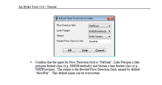
Confirm that the input for Flow Direction Grid is ???FdrSink???, Lake Polygon a lake polygon feature class (e.g. NHDWaterbody) and Stream a line feature class (e.g. NHDFlowline). The output is the Bowled Flow Direction Grid, named by default ???BowlFdr???. This default name can be overwritten.
but it can`t be done because this function requires grid data as initial to stream (grid?). So, I don`t know how to perform this tutorial further.
Best regards.
Solved! Go to Solution.
1 Solution
Accepted Solutions
02-06-2013
06:52 AM
- Mark as New
- Bookmark
- Subscribe
- Mute
- Subscribe to RSS Feed
- Permalink
- Report Inappropriate Content
There are been quite a few changes since 2.0. We are in the process of on updating the tutorials. Meanwhile your best source for the documentation is the online help for the toolbar and the toolbox. The tool now requires a stream grid input instead of stream features which were internally converted to grid by the process. In some cases, this conversion resulted in some extra "stream" cells and potential sinks. You can use as input any grid that masks the stream cells. The values of the grid cells in the stream do not matter. So you can use the stream grid or stream link grid (this one may be created by the Create Drainage Line Structures function).
Christine Dartiguenave
Esri Water Resources Team
Christine Dartiguenave
Esri Water Resources Team
3 Replies
02-06-2013
06:52 AM
- Mark as New
- Bookmark
- Subscribe
- Mute
- Subscribe to RSS Feed
- Permalink
- Report Inappropriate Content
There are been quite a few changes since 2.0. We are in the process of on updating the tutorials. Meanwhile your best source for the documentation is the online help for the toolbar and the toolbox. The tool now requires a stream grid input instead of stream features which were internally converted to grid by the process. In some cases, this conversion resulted in some extra "stream" cells and potential sinks. You can use as input any grid that masks the stream cells. The values of the grid cells in the stream do not matter. So you can use the stream grid or stream link grid (this one may be created by the Create Drainage Line Structures function).
Christine Dartiguenave
Esri Water Resources Team
Christine Dartiguenave
Esri Water Resources Team
01-15-2014
07:43 AM
- Mark as New
- Bookmark
- Subscribe
- Mute
- Subscribe to RSS Feed
- Permalink
- Report Inappropriate Content
01-22-2014
07:17 AM
- Mark as New
- Bookmark
- Subscribe
- Mute
- Subscribe to RSS Feed
- Permalink
- Report Inappropriate Content
The input depends on the operations you performed on the DEM. With that tool, you adjust the flow direction grid within the lakes so that the water flows toward the closest stream feature within the lakes. You may or not have sinks in your dem you want to preserve (or fill). So the input is your flow direction grid created and adjusted, if needed, in sinks and/or streams.
Christine Dartiguenave
Esri Water Resources Team
Christine Dartiguenave
Esri Water Resources Team