Turn on suggestions
Auto-suggest helps you quickly narrow down your search results by suggesting possible matches as you type.
Cancel
- Home
- :
- All Communities
- :
- Products
- :
- Geoprocessing
- :
- Geoprocessing Questions
- :
- Problems using tabulate area
Options
- Subscribe to RSS Feed
- Mark Topic as New
- Mark Topic as Read
- Float this Topic for Current User
- Bookmark
- Subscribe
- Mute
- Printer Friendly Page
Problems using tabulate area
Subscribe
2662
4
02-24-2012 09:46 AM
02-24-2012
09:46 AM
- Mark as New
- Bookmark
- Subscribe
- Mute
- Subscribe to RSS Feed
- Permalink
- Report Inappropriate Content
I'm trying to use tabulate area so I can do percent coverage of one layer (land ownership) inside of another layer (HUC12 watersheds). When I select some classes for the land ownership, it fails and gives me the error "Error 010010: Field not found. Invalid field index obtained." When I select other classes of land ownership, it runs successfully but outputs a table that has created a new column for every single class from the watersheds layer (BLM1, BLM2, BLM3, BLM4, BLM5...) when they should all be in the same column.
Has anyone run into this issue and have a fix? It is doing the area correctly, but it is outputting the table in a format that is unusable and does not make sense.
Has anyone run into this issue and have a fix? It is doing the area correctly, but it is outputting the table in a format that is unusable and does not make sense.
4 Replies
02-24-2012
10:11 AM
- Mark as New
- Bookmark
- Subscribe
- Mute
- Subscribe to RSS Feed
- Permalink
- Report Inappropriate Content
02-24-2012
04:30 PM
- Mark as New
- Bookmark
- Subscribe
- Mute
- Subscribe to RSS Feed
- Permalink
- Report Inappropriate Content
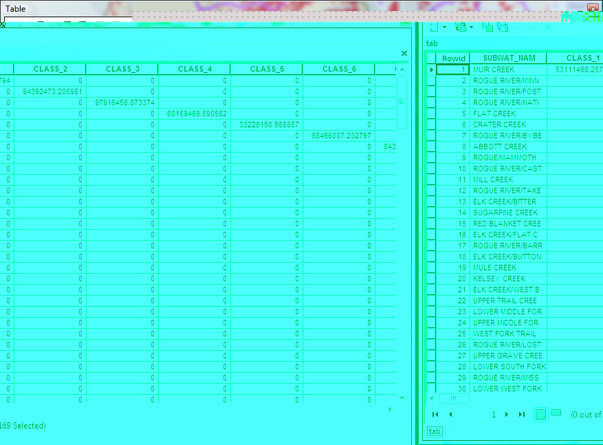
Attached is a picture of the results even though they all have the same value for class that I selected in land ownership.
Tabulate Area can be very finicky, and is dependent on your inputs to get what you want. It looks like you've labeled your land ownership classes already differently in each HUC. If it's just one class and you want percent in each, an approach you may want to try is to reclass your land ownership to 100 (fed land, say) and 0 (not fed land) using the Reclassify_sa tool or a Con_sa. Then you can run Zonal Statistics As Table with your hucs as zones. The mean of the 0 and 100 cells in each zone will then be percent fed land, for example.
We have published a tool that may help you if your problem is a little more complicated: Tabulate Areas To Percent in the NAWQA Area-Characterization Toolbox. There is a version with many bug fixes that works with both 9.3 and 10.0 on this ftp site.
Hey, MVP status. Cool!
02-25-2012
12:48 PM
- Mark as New
- Bookmark
- Subscribe
- Mute
- Subscribe to RSS Feed
- Permalink
- Report Inappropriate Content
Actually that all have an identical class, that is why I'm confused at the output. The output looks like there is a different class for each watershed, but it's all the exact same class, the output just seems to create one class for each watershed.
I guess I'll try the values and then using zonal statistics, but it really seems like tabulate area should work on this easily, but is getting confused and creating new fields for some reason. Thanks.
I guess I'll try the values and then using zonal statistics, but it really seems like tabulate area should work on this easily, but is getting confused and creating new fields for some reason. Thanks.
10-22-2019
01:35 PM
- Mark as New
- Bookmark
- Subscribe
- Mute
- Subscribe to RSS Feed
- Permalink
- Report Inappropriate Content
I was getting the same problem when my ZoneField's name was too long... shortened it (although there area still long names in that same field) and it works now.