Turn on suggestions
Auto-suggest helps you quickly narrow down your search results by suggesting possible matches as you type.
Cancel
- Home
- :
- All Communities
- :
- Products
- :
- ArcGIS Network Analyst
- :
- ArcGIS Network Analyst Questions
- :
- Network Analyst and Polygon data?
Options
- Subscribe to RSS Feed
- Mark Topic as New
- Mark Topic as Read
- Float this Topic for Current User
- Bookmark
- Subscribe
- Mute
- Printer Friendly Page
Network Analyst and Polygon data?
Subscribe
3405
6
02-13-2012 09:12 AM
02-13-2012
09:12 AM
- Mark as New
- Bookmark
- Subscribe
- Mute
- Subscribe to RSS Feed
- Permalink
- Report Inappropriate Content
Hi Guys,
I just received a demo of the network analyst in hopes to do some routing with some Disposition data. The first major problem that I have is the LOC's or in other words road data are polygons. This data is government data and I cant get this as line features. Is there anything I can do to work around this? I unfortunately don't have the license for the "polygon to line" tool.
Thanks in Advance.
~Devon
6 Replies
02-14-2012
07:30 AM
- Mark as New
- Bookmark
- Subscribe
- Mute
- Subscribe to RSS Feed
- Permalink
- Report Inappropriate Content
Hi Devon,
Could you please elaborate a bit on what is "LOC" and what polygons you got? Are you going to test a specific functionality of the Network Analyst extension (this will define what input data you'd need)?
Could you please elaborate a bit on what is "LOC" and what polygons you got? Are you going to test a specific functionality of the Network Analyst extension (this will define what input data you'd need)?
02-16-2012
11:03 AM
- Mark as New
- Bookmark
- Subscribe
- Mute
- Subscribe to RSS Feed
- Permalink
- Report Inappropriate Content
Hi Devon,
Could you please elaborate a bit on what is "LOC" and what polygons you got? Are you going to test a specific functionality of the Network Analyst extension (this will define what input data you'd need)?
Hey thanks for your response,
Basically LOC's are roads....instead of having a network of single lines I have networks of polygons.... essentially if you used the buffer tool and buffered a line by 10 meters that's what these polygons would look like. I want to use the basic functionality of network analyst by finding the shortest route from one point to another. It looks as if it is a necessity to have line networks for this extension.
thanks again,
Devon
02-16-2012
11:53 PM
- Mark as New
- Bookmark
- Subscribe
- Mute
- Subscribe to RSS Feed
- Permalink
- Report Inappropriate Content
All right. What you have to do now though is to convert your polygons into centerlines (polylines) which can be used in Network Analyst. Some alternatives you have are as below:
1) Manually digitize the lines from the polygons.
2) Run the Feature Class to Coverage tool (Conversion toolbox > To Coverage) and then run the Collapse Dual Lines to Centerline tool (Coverage toolbox > Data Management > Generalization). Experiment with max and min width of the features here.
3) Convert your polygons to raster (Conversion toolbox > To Raster > Feature to raster) and then run Shrink tool (Spatial Analyst toolbox > Generalization) to obtain a "single-line" raster. Then you can convert the raster back to vector line with the Raster to Polyline (Conversion toolbox > From Raster).
4) Use ET Geowizards from http://www.ian-ko.com/ (tool is called Create Centerlines from Polygons).
02-22-2012
12:03 PM
- Mark as New
- Bookmark
- Subscribe
- Mute
- Subscribe to RSS Feed
- Permalink
- Report Inappropriate Content
All right. What you have to do now though is to convert your polygons into centerlines (polylines) which can be used in Network Analyst. Some alternatives you have are as below:
1) Manually digitize the lines from the polygons.
2) Run the Feature Class to Coverage tool (Conversion toolbox > To Coverage) and then run the Collapse Dual Lines to Centerline tool (Coverage toolbox > Data Management > Generalization). Experiment with max and min width of the features here.
3) Convert your polygons to raster (Conversion toolbox > To Raster > Feature to raster) and then run Shrink tool (Spatial Analyst toolbox > Generalization) to obtain a "single-line" raster. Then you can convert the raster back to vector line with the Raster to Polyline (Conversion toolbox > From Raster).
4) Use ET Geowizards from http://www.ian-ko.com/ (tool is called Create Centerlines from Polygons).
Hi Alex,
Could you go into more detail about how to convert the polygons into centre lines within Network Analyst. I dont have the tool licensing for the alternatives you listed so I need to rely on the capability of the network extension.
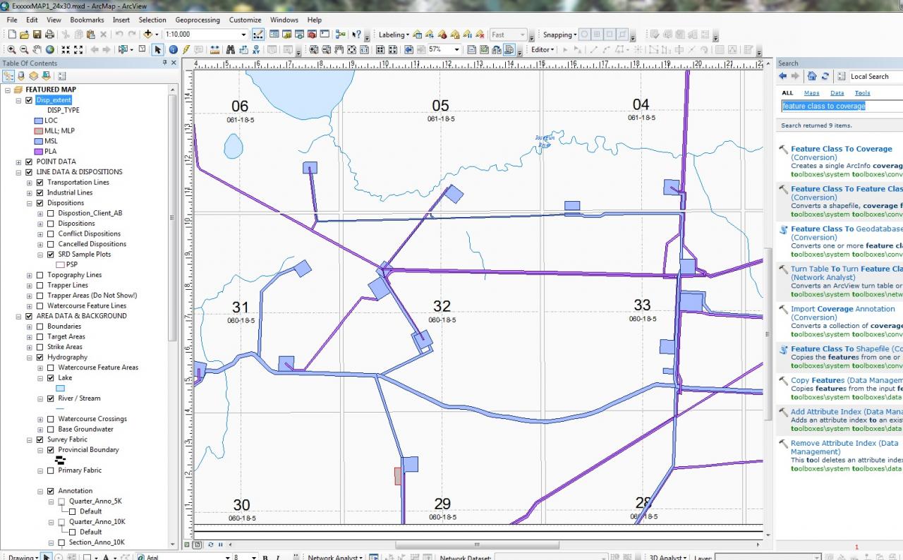
[ATTACH=CONFIG]12141[/ATTACH] Here is an attached photo to reiterate what I'm trying to do. The screen shot contains roads and well site pads; I'm trying to use Network Analyst to find shortest distances along the roads AND the pads. But I need to convert these polygons into lines.
Thanks in advance
~Devon
02-22-2012
10:34 PM
- Mark as New
- Bookmark
- Subscribe
- Mute
- Subscribe to RSS Feed
- Permalink
- Report Inappropriate Content
Hi Devon,
Network Analyst extension does not provide the functionality you are looking for. This shall be done by ArcGIS geoprocessing tools or by manual editing of your data by using, for instance, the Editor toolbar.
As a really quick solution, you can use the trace tool for a new polyline feature class from the Editor toolbar with a small offset and digitize your lines quickly yet manually (the offset would be required so you will draw a line not on the polygon border itselft but rather somewhere close to the centerline).
You can also try to search on http://arcscripts.esri.com for any script that would be useful. Personally, I do not know any script there that would run on ArcView license you have. Some other scripts are for using with ArcINFO Workstation (coverages), which you've said you do not have a license either.
Consider running the ET Geowizards or upgrade to ArcInfo 🙂
02-24-2012
06:19 AM
- Mark as New
- Bookmark
- Subscribe
- Mute
- Subscribe to RSS Feed
- Permalink
- Report Inappropriate Content
Hi Alex,
Thanks for all your advice. I do have ArcEditor aswell but still not licensed for some geoproccessing tools. It looks as if for now network analyst doesn't suite my needs. Was trying to find new ways to speed up the process of making access maps; however, with the manuel geoprocessing required it doesn't make sense to do all that work since we have such large data sets. Anyways great help, take care.
~Devon