Turn on suggestions
Auto-suggest helps you quickly narrow down your search results by suggesting possible matches as you type.
Cancel
- Home
- :
- All Communities
- :
- Products
- :
- ArcGIS GeoStatistical Analyst
- :
- ArcGIS GeoStatistical Analyst Questions
- :
- how does kriging arrive at areal level prediction?
Options
- Subscribe to RSS Feed
- Mark Topic as New
- Mark Topic as Read
- Float this Topic for Current User
- Bookmark
- Subscribe
- Mute
- Printer Friendly Page
how does kriging arrive at areal level prediction?
Subscribe
3016
13
10-05-2011 02:42 PM
10-05-2011
02:42 PM
- Mark as New
- Bookmark
- Subscribe
- Mute
- Subscribe to RSS Feed
- Permalink
- Report Inappropriate Content
I have searched the ESRI kriging-related documentation but cannot seem to find relevant information on this. It's rather straightforward with the prediction feature from the geostatistical analysis extention to predict an areal-level value from a continuous surface interplated from kriging (e.g. ordinary kriging). But what are the maths behind this process? Is it some sort of moving average based on continous values for each areal unit? How is the average calculated? I only find the basic formula for point-location predicted values, but not for areal level values. Any help or pointers in this regard is greatly appreciated.
13 Replies
10-06-2011
06:32 AM
- Mark as New
- Bookmark
- Subscribe
- Mute
- Subscribe to RSS Feed
- Permalink
- Report Inappropriate Content
The best way to do this in Geostatistical Analyst is to use the Gaussian Geostatistical Simulations tool. You first create a Simple kriging layer in the Geostatistical Wizard, then you use this layer as input to the GGS tool. Make sure to condition on the features/field that you used to interpolate, then specify the statistical polygons where you would like to make areal predictions.
This process is conditionally simulating many point values in each of the polygons, then it's calculating statistics on these simulated points within each polygon.
This process is conditionally simulating many point values in each of the polygons, then it's calculating statistics on these simulated points within each polygon.
10-06-2011
07:46 AM
- Mark as New
- Bookmark
- Subscribe
- Mute
- Subscribe to RSS Feed
- Permalink
- Report Inappropriate Content
Thanks for explaining to me the steps Eric. I am not sure if I understand it correctly but I think I should have phrased the question in terms of block kriging, or at least that's what I blieve is behind the areal-level prediction. Because I am interested in estimating areas or blocks, instead of mapping a continuous surface, I used the prediction (in the krigging output menu) feature to give an averaged value for each areal unit. What I want to know is how is this areal-level average calculated behind the scene. There is little help in the way of documentation. Are you saying the Bayesian approach is used in areal-level prediction? Could you point me to some papers, book chapters that explain the approach? Thanks a lot!
10-06-2011
09:33 AM
- Mark as New
- Bookmark
- Subscribe
- Mute
- Subscribe to RSS Feed
- Permalink
- Report Inappropriate Content
GA Layer to Grid employs block kriging where the raster/grid cells are the "areal units." We don't have block kriging to arbitrary areal units because GGS does the same job better. If your goal is to predict to areal units, we highly recommend Geostatistical simulations over block kriging or zonal statistics.
All GA Layer to Grid is doing is making predictions on a lattice within each raster cell, then taking the average of the predictions and assigning it to the raster cell. By default, it only predicts a single point at the center of the raster cell, but you can specify the dimensions of the lattice (3 by 2, for example).
We recommend "Cressie, N (1993) Statistics for spatial data, Wiley, New York" for mathematical analysis of block kriging. However, this book can be intimidating for people without a substantial background in statistics.
For a more example-driven text that is tailored to Geostatistical Analyst and GIS users:
http://esripress.esri.com/display/index.cfm?fuseaction=display&websiteID=194
Note: Neither GGS nor block kriging are "Bayesian" methods. GGS can be called a Monte Carlo method (though that phrase is rarely used), and block kriging is simply areal averaging of the surface.
10-06-2011
11:16 AM
- Mark as New
- Bookmark
- Subscribe
- Mute
- Subscribe to RSS Feed
- Permalink
- Report Inappropriate Content
Thank you Eric for helping me understand the areal prediction details. To my knowledage, when interpolating a surface from say ordinary kriging, the default is filled contour display; but when further predicting to arbitrary areal unit, you mean the gridded cell values are averaged per area/block? So even when the surface looks continous, the underlying predicted values are still cell-discretized (for a cell size of my choice i understand)?
And a separate question, when the areal units are variable in size, do larger areal units have higher prediction uncertainty (or higher estimated variance), or lower? Thanks again for your insight! I will have to make do with GA for now since i don't have a GGS license...
And a separate question, when the areal units are variable in size, do larger areal units have higher prediction uncertainty (or higher estimated variance), or lower? Thanks again for your insight! I will have to make do with GA for now since i don't have a GGS license...
10-06-2011
12:18 PM
- Mark as New
- Bookmark
- Subscribe
- Mute
- Subscribe to RSS Feed
- Permalink
- Report Inappropriate Content
Thank you Eric for helping me understand the areal prediction details. To my knowledage, when interpolating a surface from say ordinary kriging, the default is filled contour display; but when further predicting to arbitrary areal unit, you mean the gridded cell values are averaged per area/block? So even when the surface looks continous, the underlying predicted values are still cell-discretized (for a cell size of my choice i understand)?
The filled contour display is just for visual representation. The surface actually is continuous, but in order to make areal predictions, the surface is discretized. This is true for both block kriging and geostatistical simulations.
And a separate question, when the areal units are variable in size, do larger areal units have higher prediction uncertainty (or higher estimated variance), or lower? Thanks again for your insight! I will have to make do with GA for now since i don't have a GGS license...
GGS is a tool in the Geostatistical Analyst toolbox (in the Simulation toolset), so if you have a GA license, you have access to the tool. The tool was added in ArcGIS 9.3.
In general, larger areal units will have smaller standard errors from both block kriging and geostatistical simulations.
10-06-2011
01:04 PM
- Mark as New
- Bookmark
- Subscribe
- Mute
- Subscribe to RSS Feed
- Permalink
- Report Inappropriate Content
I am pretty sure i don't have this simulation tool in the GA toolset. Guess it's a lower version than 9.3 although my Arcview is 9.3. There seems to be no way to tell the version of my GA extension from the built-in GA help menu! I hope you are not exasperated by me asking this: the zonal statistics or block estimates are simple (arithmatic?) averages of cell values per block? is there local regression invovled? or kernel interpolation at the centroid of each block? Many thanks!
10-06-2011
03:47 PM
- Mark as New
- Bookmark
- Subscribe
- Mute
- Subscribe to RSS Feed
- Permalink
- Report Inappropriate Content
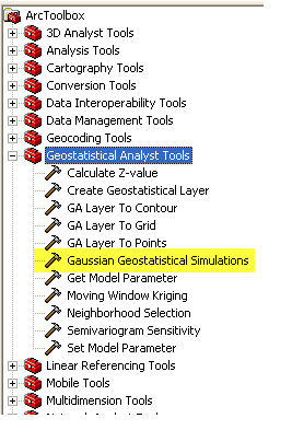
10-06-2011
04:00 PM
- Mark as New
- Bookmark
- Subscribe
- Mute
- Subscribe to RSS Feed
- Permalink
- Report Inappropriate Content
No mine only has explore data, geostatistical wizard, and create subsets. Here is what i was told 'In ArcGIS 10, this tool moved into an additional tool box (Simulation toolbox) which was not present in ArcGIS 931'. So mystery solved. The reason i ask about block kriging is that i think i have it confused with block prediction. The latter seems to be what i was doing, while block kriging seems much more complicated as it involves "averging values of the covariances over some grid of point locations within each block". So average covariance instead of individual covariance structure was adopted in block kriging, but I haven't done anything of this sort. I don't think you accomplish block kriging in the prediction phase, or is it just another term for block prediction?
10-06-2011
04:03 PM
- Mark as New
- Bookmark
- Subscribe
- Mute
- Subscribe to RSS Feed
- Permalink
- Report Inappropriate Content
Sorry i misspoke about the GA toolbox. I was looking at the tool bar. Yes i do have GGS in the toolbox. very remiss of me not to check your image closer.