- Home
- :
- All Communities
- :
- Products
- :
- ArcGIS Pro
- :
- ArcGIS Pro Questions
- :
- TopoToRaster - Invalid output extent - What's it l...
- Subscribe to RSS Feed
- Mark Topic as New
- Mark Topic as Read
- Float this Topic for Current User
- Bookmark
- Subscribe
- Mute
- Printer Friendly Page
TopoToRaster - Invalid output extent - What's it looking for?
- Mark as New
- Bookmark
- Subscribe
- Mute
- Subscribe to RSS Feed
- Permalink
- Report Inappropriate Content
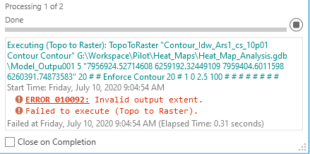
I have absolutely no idea what this tool is looking for for an output extent. I have tried "default," "current map extent," and, the one I thought was bullet-proof - I entered the input contours.
It is rejecting everything I throw at it.
Would appreciate any advice anyone is able to offer.
Thank you,
Randy McGregor
- Mark as New
- Bookmark
- Subscribe
- Mute
- Subscribe to RSS Feed
- Permalink
- Report Inappropriate Content
what's your output path? looks a bit dodgy
- Mark as New
- Bookmark
- Subscribe
- Mute
- Subscribe to RSS Feed
- Permalink
- Report Inappropriate Content
It's just an fgdb raster. That works fine. I think "default" will work for input extent, so seems good for now.
- Mark as New
- Bookmark
- Subscribe
- Mute
- Subscribe to RSS Feed
- Permalink
- Report Inappropriate Content
Are you using the tool in arctoolbox or are you using a model?
screen grab the toolbox tool inputs if you are using the former
... sort of retired...
- Mark as New
- Bookmark
- Subscribe
- Mute
- Subscribe to RSS Feed
- Permalink
- Report Inappropriate Content
Using it in a model. I changed it to "default" and it's working for now. That would be ideal. Earlier, I had not had good luck with "default" - It plugged 0,0,10,10 in for some reason. Fingers crossed.
- Mark as New
- Bookmark
- Subscribe
- Mute
- Subscribe to RSS Feed
- Permalink
- Report Inappropriate Content
Randy McGregor I will close this. If you have further issues, you can reopen
... sort of retired...