Turn on suggestions
Auto-suggest helps you quickly narrow down your search results by suggesting possible matches as you type.
Cancel
- Home
- :
- All Communities
- :
- Products
- :
- ArcMap
- :
- ArcMap Questions
- :
- ArcGIS Sample (Spatial analyst)
Options
- Subscribe to RSS Feed
- Mark Topic as New
- Mark Topic as Read
- Float this Topic for Current User
- Bookmark
- Subscribe
- Mute
- Printer Friendly Page
ArcGIS Sample (Spatial analyst)
Subscribe
375
0
06-18-2020 07:57 PM
06-18-2020
07:57 PM
- Mark as New
- Bookmark
- Subscribe
- Mute
- Subscribe to RSS Feed
- Permalink
- Report Inappropriate Content
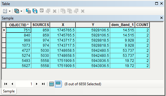
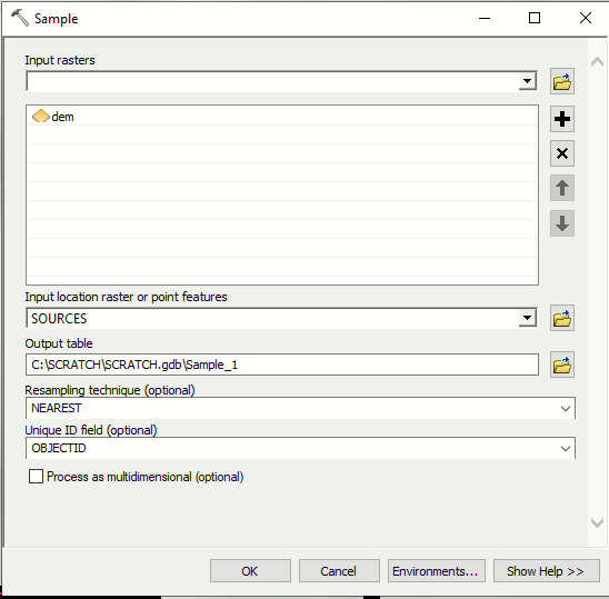
I am using ArcGIS 10.8. When I use point feature class from file geodatabase as input to Sample tool (using OBJECTID as unique ID field, see 1st attachment) output sample table has duplicate rows for point with same OBJECTID (2nd attachment). Environment setting extent, cell size and snap raster all set to raster in question.
I can get sensible output by converting points to raster, but it is an extra step I am trying to avoid.
Anyone has the same experience?
0 Replies