- Home
- :
- All Communities
- :
- Products
- :
- ArcGIS Pro
- :
- ArcGIS Pro Questions
- :
- Make fishnet that is visible but not editable
- Subscribe to RSS Feed
- Mark Topic as New
- Mark Topic as Read
- Float this Topic for Current User
- Bookmark
- Subscribe
- Mute
- Printer Friendly Page
Make fishnet that is visible but not editable
- Mark as New
- Bookmark
- Subscribe
- Mute
- Subscribe to RSS Feed
- Permalink
- Report Inappropriate Content
I'm currently using a polyline fishnet grid to use as a guide when labelling land features. For example, I aim to label 10 grids per day.
An issue I have is that when creating my polygons they keep snapping to the fishnet by accident.
How can I have the fishnet visible so that I can use it as a visual guide but not interactive, so I do not snap to it by accident when creating polygons?
I use both ArcGIS and QGIS to create shapefiles, so need a solution that works across both software.
Note: I need to know the grid ID to keep a log of progress, so I would like a solution where I can still determine grid ID (either visually or by opening the attribute table).
- Mark as New
- Bookmark
- Subscribe
- Mute
- Subscribe to RSS Feed
- Permalink
- Report Inappropriate Content
It sounds like you just need to turn snapping off for the fishnet layer:
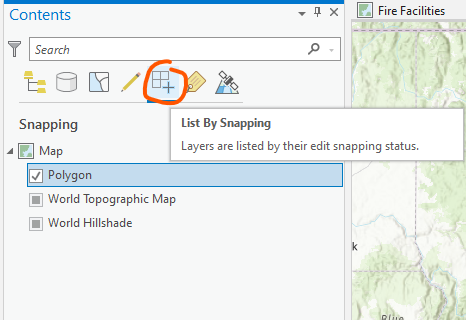
Enable or disable snapping by layer—ArcGIS Pro | Documentation
- Mark as New
- Bookmark
- Subscribe
- Mute
- Subscribe to RSS Feed
- Permalink
- Report Inappropriate Content
Thanks Kory! Do you know if it's possible to enable/disable the snapping status of layers in QGIS?
- Mark as New
- Bookmark
- Subscribe
- Mute
- Subscribe to RSS Feed
- Permalink
- Report Inappropriate Content
t t - I found this link via a Google search - perhaps this will help you with QGIS.