- Home
- :
- All Communities
- :
- Products
- :
- ArcGIS Pro
- :
- ArcGIS Pro Questions
- :
- Create Ellipsoid in ArcGIS Pro Local Scene
- Subscribe to RSS Feed
- Mark Topic as New
- Mark Topic as Read
- Float this Topic for Current User
- Bookmark
- Subscribe
- Mute
- Printer Friendly Page
Create Ellipsoid in ArcGIS Pro Local Scene
- Mark as New
- Bookmark
- Subscribe
- Mute
- Subscribe to RSS Feed
- Permalink
- Report Inappropriate Content
I'm trying to add or create an ellipsoid in an ArcGIS Pro local scene between two xyz points above ground. The distance between the two points is 8 miles. The ellipsoid radius is 50 feet. The points are 150 and 180 feet above ground, respectively. The points are described by latitude, longitude and height above ground.
I've tried line-of-sight lines and buffered them in 3D. This gives a cylinder that is pretty good but the ellipsoid would be a better representation of reality.
This picture below is the closest I've been able to get but it's far from usable. This will be used in 3D analysis so it needs to be spot on the locations.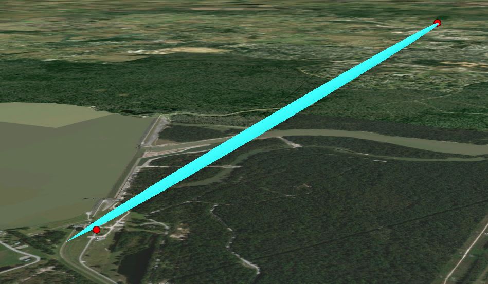
The attempt pictured started with a multipatch sphere. It is pitched 90 degrees on its side and stretched using the modify/scale tool. I need some way to move the object so that it can snap to the points.
What might be ideal would be a GP tool or python script to create this ellipsoid from scratch. Given the two major axis z-value endpoints and the radius, create the object.
The points represent radio antennas on towers and the ellipsoid represents the radio wave clearance zone or Fresnel zone.
I've started looking at Blender and SketchUp but I don't know either package and would prefer a native ArcGIS solution.
Any help will be appreciated.
Thanks,
Bill
- Mark as New
- Bookmark
- Subscribe
- Mute
- Subscribe to RSS Feed
- Permalink
- Report Inappropriate Content
Hi there, were you able to figure this one out? I am in the same boat now, almost 4 years later from your post.